
I-95 Corridor Snowstorm Setup Tightens as EURO AI Tracks Within 100 Miles, Raising 6-Inch+ Potential From Washington to New York
WASHINGTON, D.C. — With just two days to go, confidence is cautiously building in a high-impact winter setup along the I-95 corridor, as the latest ECMWF AIFS (EURO AI) model run tracks the developing storm within roughly 100 miles of earlier projections. That subtle shift has major implications for snowfall totals from Washington, D.C. and Baltimore through Philadelphia, New York City, and into southern New England.
The key question now: Will the storm’s northern and southern branches phase in time to produce a significant snow band — defined by some forecasters as 6 inches or more — directly along the urban corridor?
EURO AI Highlights 6–9 Inch Band Near Major Cities
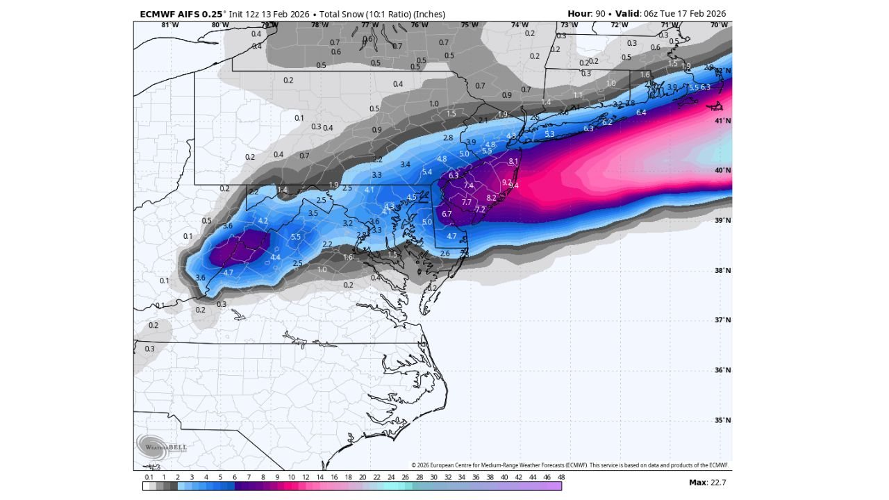
The latest total snowfall map valid early Tuesday morning (06Z February 17) paints a striking corridor of heavier accumulation stretching northeastward from northern Virginia and Maryland through Delaware, southeastern Pennsylvania, New Jersey, and into the New York metro area.
Projected snowfall totals in the current guidance include:
- Washington, D.C.: 3 to 5 inches
- Baltimore, Maryland: 3 to 5 inches
- Philadelphia, Pennsylvania: 6 to 8 inches
- Central and southern New Jersey: 7 to 9 inches
- New York City and Long Island: 6+ inches, with higher totals just offshore
The heaviest band appears aligned just southeast of the I-95 spine, with a gradient tightening sharply north of the axis. Areas into central Pennsylvania and upstate New York show lighter totals under 2 inches, highlighting how precise storm track placement remains critical.
Phasing Timing Remains the Deciding Factor
Forecasters continue to emphasize the importance of timing between the system’s southern branch energy and its northern stream counterpart.
If:
- The southern branch arrives roughly six hours faster, and
- The northern branch lags by about six hours,
The two features could phase strongly enough to enhance lift along the coast, deepening the storm and expanding the heavier snow shield up the I-95 corridor.
If that phasing does not materialize cleanly, snowfall amounts could shift eastward or weaken considerably.
That conditional setup explains the ongoing caution in messaging, even as the EURO AI trends closer to earlier projections.
Sharp Northern Cutoff Remains a Risk
The snowfall map shows a pronounced northern cutoff. Locations just 30 to 50 miles northwest of the heavy band — including parts of northern Maryland, central Pennsylvania, and interior New York — fall off quickly to lighter totals.
That tight gradient means small track adjustments could:
- Increase totals in Washington and Baltimore
- Shift the 6-inch axis into central New Jersey and away from Philadelphia
- Or push the heaviest snow offshore
Such narrow margins are common in coastal storm setups affecting the Mid-Atlantic and Northeast.
Two Days Out: Confidence Improving, But Not Locked In
While the EURO AI solution aligns more closely with prior forecasts, forecasters stress that the event is not yet finalized.
A key benchmark referenced earlier in the week — measurable rainfall at Los Angeles International Airport (LAX) tied to analog criteria — was not met, adding another layer of uncertainty to long-range comparisons.
Still, the narrowing model spread and improving clustering near the coast suggest that the storm track is stabilizing.
With just 48 hours remaining, attention now turns to:
- Updated phasing signals
- Thermal profiles near the rain-snow line
- Mesoscale banding potential
What I-95 Residents Should Prepare For
If the current projection verifies, major metropolitan areas from Washington to New York could experience plowable snow during the overnight hours Monday into early Tuesday.
Commuters should monitor updates closely, as early Tuesday travel could be impacted in cities where totals exceed 6 inches.
Even in areas projected for 3 to 5 inches, bursts of heavier snowfall could reduce visibility and create slick road conditions.
As the coastal storm approaches, additional model runs over the next 24 hours will refine placement of the heavy snow band and clarify final totals.
For continued updates on Mid-Atlantic and Northeast winter storm developments, snowfall tracking, and I-95 corridor forecasts, visit ChicagoMusicGuide.com for the latest weather coverage.