
Ice Storm Risk Emerges for Maryland and Pennsylvania Friday, With Snow Potential Extending Into New York
PENNSYLVANIA — A potentially disruptive winter weather system is taking shape for Friday into early Saturday, with freezing rain and sleet increasingly likely across parts of Maryland and Pennsylvania, while snow becomes more probable farther north into New York. Forecast data continues to trend colder, raising concerns about icy travel conditions, power disruptions, and difficult holiday movement across the region.
Why Forecasters Are Concerned
Meteorologists are closely monitoring a developing overrunning winter setup, where warm, moisture-rich air rides over a shallow layer of cold air near the surface. This configuration often leads to freezing rain rather than snow, especially in areas sitting near the boundary between competing air masses.
Current guidance shows a blocking high pressure system over the North Atlantic, helping to hold cold air in place across the Mid-Atlantic. As precipitation moves in late Friday, surface temperatures in many areas of central Maryland and southern to central Pennsylvania are expected to hover between 28°F and 30°F, an ideal range for freezing rain accumulation.
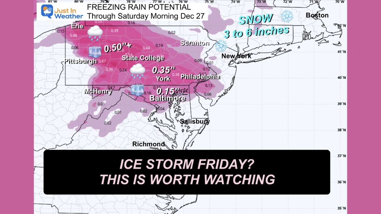
Freezing Rain and Ice Accumulation Potential
Model projections indicate measurable ice accretion is possible, particularly from:
- Central and western Maryland, including the Baltimore metro and surrounding counties
- South-central and central Pennsylvania, including areas near York, State College, and toward the Appalachian foothills
Some forecast scenarios suggest ice totals exceeding one-quarter inch, with localized higher amounts if freezing rain persists longer than expected. Even lighter icing can create dangerous road conditions and stress trees and power lines, especially if precipitation continues for several hours.
Sleet vs. Snow: A Sharp Gradient
Just north and east of the freezing rain zone, sleet may mix in, particularly during the transition period Friday evening. Farther northeast, colder air is expected to dominate, allowing precipitation to fall mainly as snow across much of New York and parts of New England.
Snowfall projections for those areas currently range from 3 to 6 inches, though totals could change depending on how quickly colder air pushes south and east. Cities closer to the rain-snow line could see sharp differences over short distances.
Timing Still a Key Question
While confidence is growing in the overall setup, exact timing remains uncertain. Current indications favor:
- Friday afternoon into Friday evening for the onset of freezing rain and sleet
- Friday night into early Saturday for lingering icy conditions before precipitation tapers off
Some forecast models have shown a tendency to run late, meaning impacts could begin earlier than currently projected. Residents with travel or event plans are encouraged to use the morning hours when possible and remain flexible.
Holiday Travel Impacts Possible
The timing of this system, arriving just after Christmas, raises concerns for post-holiday travel across the I-95 corridor and interior routes. Airports, highways, and secondary roads could all be affected, particularly where freezing rain develops.
Drivers should prepare for:
- Rapidly deteriorating road conditions
- Reduced visibility
- Possible delays or cancellations, especially Friday evening
What Happens Next
This system is still evolving, and small temperature changes will have major impacts on precipitation type. Forecasters emphasize that exact ice and snow amounts will become clearer over the next 24–48 hours, but the current signal is strong enough to warrant close attention.
Residents across Maryland, Pennsylvania, and New York should continue monitoring forecasts and be prepared for changing winter conditions as Friday approaches.
For continued updates, regional impact breakdowns, and weather-related travel advisories, follow ChicagoMusicGuide.com as we track this developing winter weather threat.