
Illinois and Great Lakes Winter Storm Could Deliver 4–10 Inches of Snow, Dangerous Ice, and Whiteout Travel Conditions Late December 28–30, Forecasters Warn
CHICAGO, ILLINOIS — A developing late December winter storm is drawing growing attention from meteorologists as forecast models indicate a sharp snowfall gradient across Illinois, with significantly heavier snow totals possible north of Chicago while much of central and southern Illinois may see little to no accumulation. The latest high-resolution guidance highlights a storm track favoring the Upper Midwest and Great Lakes, placing northern Illinois near the southern edge of impactful snowfall.
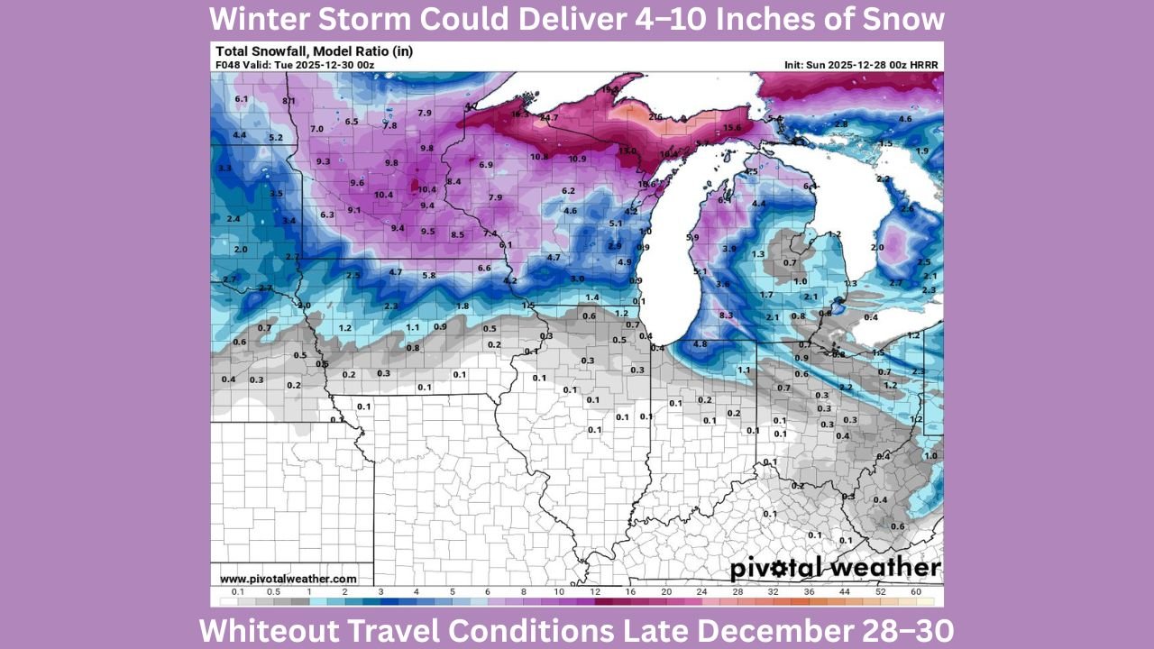
Forecast data valid through early Tuesday, December 30, shows snow totals rapidly increasing just north of the Illinois state line, underscoring how small shifts in storm position could dramatically change impacts for the Chicago area.
Model Guidance Highlights a Tight Snowfall Cutoff
Current snowfall projections show a pronounced north-to-south cutoff across Illinois. Areas near the Wisconsin border could see several inches of snow if the storm track dips slightly south, while locations farther south across the state remain largely snow-free in the latest runs.
This sharp gradient is typical of strong winter systems driven by intense temperature contrasts. A slight adjustment in the storm’s path could pull heavier snow bands closer to northern Illinois, including parts of the Chicago metro area.
Forecasters caution that confidence in exact snowfall totals remains limited at this range, but the setup warrants close monitoring offering both high-impact potential and high uncertainty.
Heaviest Snow Focused Across the Upper Midwest and Great Lakes
The most substantial snowfall is currently projected across Minnesota, northern Wisconsin, and Michigan, where model data suggests double-digit snowfall totals are possible. Some areas north of the Great Lakes show signals for over a foot of snow, driven by strong moisture transport and favorable cold air placement.
Northern Illinois sits just south of this main snow axis. While current projections keep Chicago on the lower end of accumulation, even modest southward shifts could bring accumulating snow and hazardous travel to the region.
Lake-enhanced snowfall may also play a role later in the event, particularly for areas downwind of Lake Michigan.
Timing and Potential Impacts for Illinois
The storm is expected to organize late Sunday into Monday, with the highest impacts north of Illinois during that period. For Illinois residents, the primary concerns include rapid forecast changes, possible travel disruptions, and lingering cold conditions even if snowfall remains limited.
Should snow bands extend farther south, impacts could include slick roads, reduced visibility, and delays during a busy post-holiday travel period.
Meteorologists emphasize that while some Illinois communities may see little more than flurries, others—especially in the far north—could experience quick accumulations if the storm track shifts.
Why This Forecast Is Still Uncertain
The storm’s evolution depends heavily on how quickly it intensifies and where the strongest temperature gradients set up. These factors can lead to dramatic differences over short distances, which is why snowfall maps show such stark contrasts across Illinois.
Forecast confidence will improve as the storm draws closer and additional model data becomes available.
As Illinois heads into the final days of December, residents are encouraged to stay informed and prepared for possible forecast changes. For continued updates on Illinois winter weather, snowfall projections, and regional impacts, visit ChicagoMusicGuide.com for the latest coverage.