
Illinois, Indiana and Iowa Facing 2.7+ Inches Above-Normal Rainfall April 1–5 — NOAA, ECMWF and GFS All Pointing at the Corn Belt
CHICAGO, IL — A major above-normal precipitation event is locked in for millions across the central United States between April 1–5, 2026 — and every top-tier weather model on the planet is saying the same thing. From the heart of the Corn Belt to the Great Lakes shoreline, this is not a pattern to ignore. The data is clear, the models are aligned, and the window to prepare is right now.
NOAA Makes It Official: The Central U.S. Is the Target
The Climate Prediction Center (CPC) released its official 6–10 Day Precipitation Outlook on March 26, 2026, valid April 1 through April 5 — and the map is sending an unmistakable signal.
Two major above-normal precipitation zones are confirmed:
- The Intermountain West corridor — Nevada, Utah and Colorado — carrying a 50–70% probability of above-normal rainfall
- The Central U.S. core zone — covering Iowa, Illinois, Indiana, Missouri, Kentucky and into the Great Lakes — flagged at a striking 70–90%+ probability of above-normal precipitation
This is the highest-confidence zone on NOAA’s entire national map. The Southeast and Mid-Atlantic are expected to remain near normal, while the southern Plains sit in a transitional zone with uncertainty on both sides.
NOAA is not hedging here — the Midwest is the bullseye.
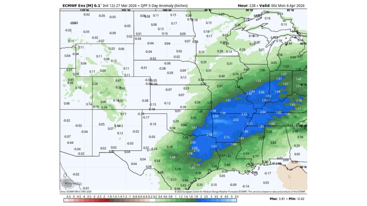
ECMWF Ensemble: The Wettest and Most Aggressive Signal
The European Centre for Medium-Range Weather Forecasts (ECMWF) Ensemble, initialized 12z March 27, 2026, is producing the most aggressive rainfall anomaly of any model in this comparison — and the numbers are alarming for parts of the Corn Belt.
Key anomaly values from the ECMWF:
- Southern Illinois and western Kentucky — peak anomalies reaching +2.78 inches above normal
- Central Illinois, Indiana and Ohio — running +1.50 to +2.33 inches above climatology
- Michigan and western Ohio — showing +1.22 to +1.94 inches above normal
- Western Kansas and Missouri transition zone — moderate anomalies of +0.84 to +1.61 inches
The deep blue zone dominating the ECMWF map signals strong ensemble agreement across all members. This is not a fringe or outlier solution. The model is pointing directly at the Illinois-Indiana-Kentucky corridor as the epicenter of this rainfall event — and it is doing so with high confidence.
ECMWF AIFS Ensemble: Same Pattern, Slightly Pulled Back on Totals
The ECMWF Artificial Intelligence Forecast System (AIFS) Ensemble at 0.25° resolution, also initialized 12z March 27, broadly confirms the wet pattern — but introduces some important regional nuances worth watching.
AIFS key anomaly values:
- Southern Illinois and western Indiana — peak anomalies of +1.87 to +2.02 inches
- Iowa, Missouri and Kentucky — running +1.26 to +1.73 inches above normal
However, the AIFS draws a sharp and critical boundary across the southern Plains. Nebraska, Kansas and Oklahoma are showing drier-than-normal anomalies, with values running into negative territory. This is a stark contrast to the wet zone directly to the northeast — and agricultural interests across those states must monitor this boundary closely as the pattern evolves.
The AIFS confirms the Midwest wet signal but dials back totals — and raises a drying flag for the southern Plains.
GFS Ensemble: Most Conservative — But Still on Board
The Global Forecast System (GFS) AI Ensemble at 0.25° resolution, initialized 12z March 27, is the driest of the three solutions — but it still clearly supports above-normal conditions across the Upper Midwest and is not backing away from the core wet signal.
GFS key anomaly values:
- Illinois, Indiana and Ohio — anomalies of +0.98 to +1.57 inches above normal
- Localized peak values reaching +1.74 inches in portions of the Midwest
- Kansas, Oklahoma and the Texas Panhandle — showing -0.28 to -0.59 inches below normal, consistent with the AIFS drying signal
Even the most conservative model in this suite is backing NOAA’s official outlook. Three models, one message — the central Midwest is getting hit.
What This Means on the Ground
All three models and NOAA’s CPC outlook are locked in on these critical points for the April 1–5 window:
- Illinois, Indiana, Iowa, Ohio and the Great Lakes are the highest-confidence areas for significant above-normal rainfall
- ECMWF peak anomalies exceed +2.78 inches — raising serious flash flooding and soil saturation concerns across the region
- Early planting season across the Corn Belt faces major disruption — Iowa and Illinois farmers could see significant fieldwork delays heading into a critical agricultural window
- River levels along the Illinois and Ohio corridors are at elevated risk of rising rapidly with this volume of excess precipitation
- The southern Plains — Kansas, Oklahoma and Texas — may actually trend drier, creating a sharp and significant weather divide across the region
Bottom Line: The Signal Is Strong — Watch This Closely
This is a high-confidence, multi-model-supported precipitation event for the central United States. The ECMWF, AIFS and GFS are all in agreement on the big picture — above-normal rainfall is coming to the Midwest, and it is coming fast. The finer details on exact totals and placement will sharpen as April 1 approaches, but waiting is not the play here.
Whether you are a farmer in Iowa, a resident near the Illinois River, or an emergency manager in Indiana — this is the week to get your plans in order. The models have spoken.
Data Sources: NOAA/CPC 6–10 Day Precipitation Outlook — March 26, 2026 | ECMWF Ensemble Mean 12z March 27, 2026 | ECMWF AIFS Ensemble 12z March 27, 2026 | GEFS AI Ensemble 12z March 27, 2026
Follow ChicagoMusicGuide.com for More Weather Updates
Don’t get caught off guard by the next major weather event. Follow ChicagoMusicGuide.com on NewsBreak for real-time breaking weather analysis, multi-model comparisons and severe weather alerts across the United States — delivered straight to your feed before the storm hits.