
Illinois, Indiana and Kentucky Remain in Tornado Crosshairs as StormNet Signals Multiple Twisters Thursday Night
INDIANAPOLIS, INDIANA — Confidence remains steady in a Thursday tornado threat across portions of Illinois, Indiana, and Kentucky, despite earlier questions about instability. New probabilistic guidance from StormNet-v4 indicates that multiple tornadoes remain possible Thursday evening into the overnight hours, with the highest probabilities centered over the lower Midwest.
Forecasters stress this was never expected to be a classic “slam dunk” severe weather outbreak. Instead, it is a high-shear setup where storm organization — not widespread instability — determines the outcome.
StormNet Highlights Focused Tornado Corridor
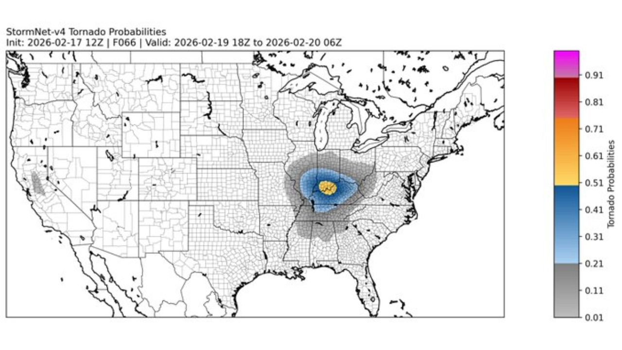
The latest StormNet-v4 tornado probability map shows a concentrated zone of elevated risk stretching across central and southern Illinois into central Indiana and western Kentucky.
The highest probability shading appears centered near the Illinois–Indiana border, extending southeast toward Louisville, Kentucky. While probabilities are not extreme, they are significant enough to support the potential for multiple tornadoes, especially if storms mature within the strongest wind fields.
Areas including Indianapolis, Terre Haute, Evansville, and Louisville fall within the broader highlighted zone.
High Wind Shear Remains the Driving Factor
Even though atmospheric instability is modest, strong mid-level and upper-level wind shear continues to compensate. This type of setup can allow storms to rotate quickly if they can develop along frontal boundaries.
Forecasters note that convective-allowing models (CAMs) are generally aligned with earlier expectations. When outlier solutions are removed, most short-range guidance supports a corridor of rotating storms Thursday evening.
In high-shear environments, even limited thunderstorm development can produce quick-hitting tornadoes, particularly along warm frontal boundaries or discrete storm cells ahead of the main line.
Timing: Late Afternoon Through Overnight
The tornado window appears most likely from late Thursday afternoon through the overnight hours into early Friday morning.
As a surface low moves through the region, storms may form along a cold front or ride a lifting warm front. Any storms that can sustain themselves within the strongest wind fields may acquire rotation.
While widespread tornado activity is not expected, the environment supports the possibility of multiple isolated tornadoes, especially across central Indiana and southern Illinois.
Not a Widespread Outbreak — But Not a Bust
Forecasters emphasize this is not shaping up as a major outbreak day with widespread long-track tornadoes. However, it also has not meaningfully “downgraded.”
The atmospheric ingredients remain supportive of rotating storms in a focused corridor. In similar past setups, storms have occasionally over-performed once sufficient storm organization occurred.
The key question remains storm coverage. If storm development is limited, tornado reports could be sparse. If discrete cells form and remain semi-isolated, the tornado count could increase quickly.
Communities in the Risk Zone Should Stay Alert
Residents across Illinois, Indiana, and Kentucky should monitor local forecasts and ensure weather alerts are enabled Thursday evening. Even isolated tornadoes can cause localized damage, especially if storms move quickly.
Primary cities to watch include:
- Indianapolis, Indiana
- Terre Haute, Indiana
- Evansville, Indiana
- Louisville, Kentucky
- Springfield, Illinois
Preparedness remains critical, particularly given the potential for overnight storms when visibility is reduced and people are less likely to receive warnings immediately.
As this dynamic Midwest setup unfolds, ChicagoMusicGuide.com will continue providing updates on tornado probabilities, storm timing, and regional impacts. For ongoing severe weather coverage across Illinois, Indiana, and Kentucky, visit ChicagoMusicGuide.com.