
Illinois, Indiana and Northeast Missouri Face Strong Tornado Threat as Double-Barreled Severe Weather Outbreak Targets Midwest and Texas Tuesday
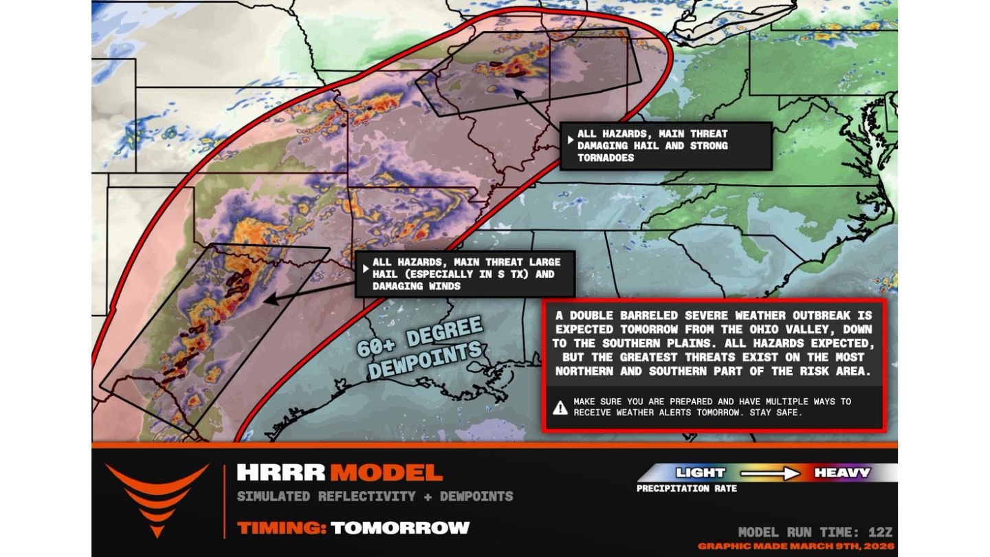
ILLINOIS — A rare double-barreled severe weather outbreak is expected to unfold Tuesday afternoon and evening, with one zone of concern stretching from northeast Missouri across northern Illinois into northern Indiana, and a second severe corridor developing across West Texas into the Texas Hill Country. Forecast guidance indicates that both regions could see supercells capable of strong tornadoes, large hail, and damaging winds.
Meteorologists highlight that the most significant threats appear focused on the northern and southern edges of the overall risk area, meaning parts of Illinois and Texas may face heightened severe weather potential at nearly the same time.
Warm Front Across Northern Illinois Sets Stage for Tornadoes
The northern branch of this outbreak centers along a warm front extending from far northeast Missouri through northern Illinois and into northern Indiana. Dew points are forecast to climb into the upper 60s, an unusually rich level of moisture this far north in early March.
As the afternoon progresses, a strengthening low-level jet stream is expected to intensify just above the warm front. This increase in wind speed and directional shear creates an environment favorable for rotating supercells.
Forecast timing suggests storms may begin developing between 4 p.m. and 6 p.m., particularly from the northeast corner of Missouri toward the Peoria, Illinois area. If storms can mature along the boundary, the environment would support:
- Strong tornadoes
- Large hail
- Damaging straight-line winds
However, meteorologists caution that upper-level forcing may initially be somewhat weak or delayed, which could impact storm initiation timing. Still, once storms form in this high-shear environment, rapid intensification is possible.
Illinois in the Crosshairs During Peak Evening Hours
Northern and central portions of Illinois, especially areas near and north of the warm front, are positioned within the corridor highlighted for the greatest tornado concern. The overlap of deep moisture, strong wind shear, and surface boundaries makes this region particularly sensitive to supercell development.
If storms become surface-based along the boundary, they could produce strong, potentially long-tracked tornadoes during the late afternoon and evening hours.
Communities across Peoria, Rockford, northern Illinois suburbs, and into northern Indiana should remain alert as storm development timing becomes clearer Tuesday afternoon.
Even outside of tornadoes, large hail and damaging winds are likely hazards in any organized storm cluster that develops across Illinois.
Southern Severe Mode Develops Across West Texas
Simultaneously, a second severe weather corridor is forecast to develop along a dry line across West Texas into the Texas Hill Country. Storms in this region could fire slightly earlier, potentially around 4 p.m. or 5 p.m., as daytime heating maximizes instability.
While Texas storms may initially pose a greater large hail threat, the atmospheric setup still supports the possibility of tornado development, including the potential for a strong tornado in isolated cases.
The southern branch of this outbreak underscores why forecasters are calling this a double-barreled event — two distinct regions separated by hundreds of miles, both capable of producing severe weather simultaneously.
All Hazards Possible Across Broad Risk Area
The overall risk area extends from the Southern Plains through the Ohio Valley, with all modes of severe weather possible. However, forecast discussions emphasize that the most intense threats exist at the northern and southern ends of the corridor — specifically across Illinois, northern Indiana, northeast Missouri, and parts of Texas.
This pattern often produces supercells ahead of advancing storm clusters, increasing the potential for isolated but significant tornadoes before storms merge into larger complexes.
Given the magnitude of moisture — including 60+ degree dew points pooling along the warm front — combined with strengthening wind fields, Tuesday’s setup resembles a classic spring severe weather pattern.
Preparedness Critical as Storm Timing Nears
Because storms are expected to develop during the late afternoon and early evening, many residents across Illinois, Indiana, Missouri, and Texas could be traveling or finishing work when warnings are issued.
Emergency managers recommend:
- Having multiple ways to receive weather alerts
- Reviewing tornado shelter plans
- Staying aware of rapidly changing radar conditions
As this double-barreled severe weather outbreak approaches, the focus will sharpen on where storms initiate first and how quickly they organize into rotating supercells.
For continued updates on Illinois severe weather, Texas storm development, and Midwest tornado risk, visit ChicagoMusicGuide.com for comprehensive coverage as conditions evolve.