
Illinois, Indiana and Ohio Could See High-Shear Storm Threat Thursday as Warm Front Collides With Powerful Jet Stream
CHICAGO, ILLINOIS — Thursday’s weather setup across Illinois, Indiana, and Ohio is shaping up to be unusually dynamic, with forecasters watching a rare combination of very low instability but extremely high wind shear. While atmospheric “fuel” for storms appears limited, a powerful mid-level jet stream sweeping across the Midwest could compensate — potentially allowing storms to intensify rapidly if they can organize along a lifting warm front.
Meteorologists caution that this is not a classic high-instability severe weather day. Instead, the risk hinges on whether storms can tap into strong winds aloft while riding the warm frontal boundary.
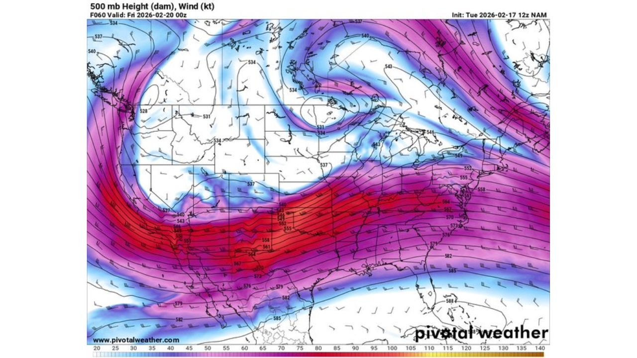
Powerful Jet Stream Overhead
Upper-level maps show a pronounced 500mb trough digging across the central United States, with a corridor of intense wind speeds extending from the southern Plains into the Midwest and Great Lakes.
This strong jet streak — highlighted by deep red and purple shading — stretches into Missouri, Illinois, Indiana, and Ohio, placing cities like Chicago, Indianapolis, and Columbus beneath significant mid-level wind energy.
High wind shear, or changing wind speed and direction with height, is one of the most critical ingredients for storm rotation. Even modest thunderstorms can rotate in environments where shear is strong enough.
Warm Front Placement Will Be Critical
Surface temperature projections show a sharp contrast between cooler air across the Upper Midwest and much warmer air surging north from the southern United States.
Temperatures in the 30s and low 40s extend across parts of Wisconsin and northern Michigan, while readings in the 60s and even low 70s push into southern Illinois, Kentucky, Tennessee, and Missouri.
The boundary between these air masses — the warm front — is expected to lift northward into central Illinois and Indiana during the day.
If thunderstorms form along this boundary and track east or northeast, they could “ride” the warm front for a period of time. That interaction often enhances rotation potential, particularly when high shear is present.
Low Instability Adds Uncertainty
Despite impressive wind dynamics, instability remains limited. Cooler air aloft and modest surface heating mean thunderstorms may struggle to grow tall enough to fully tap into the stronger winds overhead.
Forecasters describe the setup as conditional. If storms can overcome the limited instability and intensify, the environment could support rotating storms or isolated severe weather.
If storm development remains shallow or sparse, impacts may be minimal.
This balance between weak instability and strong shear makes Thursday’s forecast especially challenging across Illinois, Indiana, and western Ohio.
Areas Most Likely to See Activity
The corridor of greatest concern stretches from central and southern Illinois through Indianapolis and into western Ohio. Farther north into Chicago and northern Indiana, cooler air may limit storm intensity.
Farther south into Kentucky and southern Missouri, warmer temperatures are present, but shear alignment along the warm front will determine where organized storms develop.
Timing also plays a key role. Afternoon and early evening appear to be the primary window for any stronger storm development.
Why This Setup Bears Watching
High-shear, low-instability setups are known for producing fast-moving storms that can briefly intensify if they find just enough surface-based energy.
Key factors to monitor include:
- Exact position of the warm front
- Storm initiation along the boundary
- Ability of storms to grow vertically
- Strength of surface-based instability
While this does not appear to be a widespread severe outbreak, the atmospheric ingredients suggest that any storm that strengthens could become impactful quickly.
Residents across Illinois, Indiana, and Ohio should remain weather-aware Thursday, especially during the afternoon hours.
ChicagoMusicGuide.com will continue tracking this evolving Midwest setup and provide updates as confidence increases. For continued severe weather analysis and regional forecast coverage, visit ChicagoMusicGuide.com.