
Illinois, Indiana and Ohio May Catch a Break in April as Texas, Oklahoma and the Southern Plains Turn Drier After an Active March
UNITED STATES — After what is shaping up to be an exceptionally active March across much of the country, early April projections suggest a noticeable shift in the precipitation pattern — bringing potential relief to some regions while drying out others.
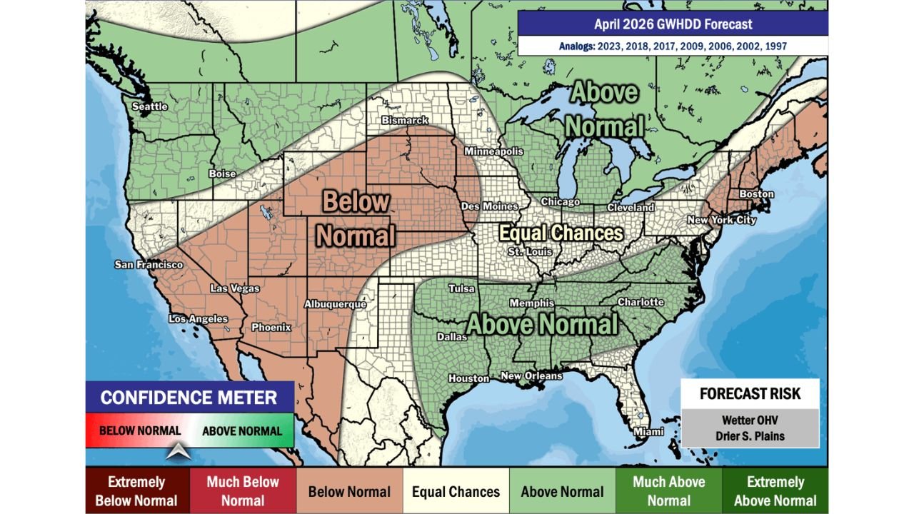
The updated April precipitation outlook indicates a split pattern across the nation, with wetter-than-normal conditions favored in parts of the Ohio Valley and Great Lakes, and drier-than-normal trends emerging across the Southern Plains and portions of the West.
Wetter Pattern Favored for Ohio, Indiana and Parts of Illinois
Green shading across the map highlights an above-normal precipitation signal centered over:
- Ohio
- Indiana
- Portions of Illinois
- Kentucky
- Tennessee
- The Lower Mississippi Valley
- Parts of the Southeast
For Chicago and northern Illinois, the outlook places the region closer to the “equal chances” zone, meaning rainfall totals could lean near seasonal averages. However, much of Indiana and Ohio sit more squarely within the above-normal category.
This suggests that while March may bring repeated storm systems, April could still remain unsettled in the eastern Midwest — though potentially with longer breaks between systems.
Southern Plains Trending Drier
A broad area of below-normal precipitation is projected across:
- Texas
- Oklahoma
- Kansas
- New Mexico
- Arizona
- Portions of Colorado
- Parts of Utah and Nevada
The Southern Plains in particular show a clearer drying signal. After potential heavy storm activity in March, April may deliver fewer storm systems and more extended dry stretches.
The outlook even labels “Drier S. Plains” as a forecast risk zone.
Equal Chances Across the Central Midwest
Central portions of the country — including:
- Missouri
- Iowa
- Southern Illinois
- Parts of Minnesota
fall into an “equal chances” category, meaning no strong signal toward above- or below-normal rainfall.
This transitional zone separates the wetter Ohio Valley pattern from the drier Plains pattern.
Great Lakes Lean Wet
The Great Lakes region, including:
- Michigan
- Northern Ohio
- Northern Indiana
shows a stronger above-normal signal. That could translate into more frequent rain systems and potentially elevated river levels if soils remain saturated from March activity.
April Could Offer Longer Gaps Between Storms
While storm systems are not expected to disappear entirely, the overall messaging suggests:
- Longer dry breaks between systems
- Less frequent large-scale severe outbreaks compared to March
- More typical early-spring variability
For agricultural interests, especially across parts of the Midwest, this could provide improved windows for planting operations — assuming rainfall distribution verifies as projected.
Bottom Line
April is shaping up to feature a wetter-than-normal pattern across Ohio, Indiana and parts of Illinois, while Texas, Oklahoma and much of the Southern Plains trend drier following an active March.
The Midwest sits near the dividing line between wetter and drier zones, meaning even small shifts in storm tracks could alter local outcomes.
ChicagoMusicGuide.com will continue monitoring long-range trends as spring unfolds across Illinois, Indiana and the broader Midwest.