
Illinois, Indiana and Wisconsin Hit by Intensifying Evening Storm Line With Damaging Winds Rising and Tornado Risk Still Lingering Near Chicago and Rockford
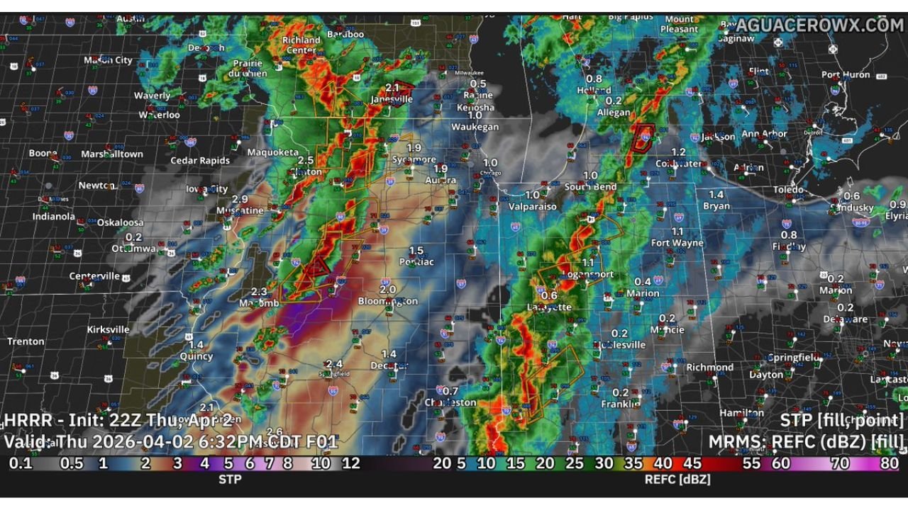
ILLINOIS — Severe storms are rapidly intensifying across the Midwest this evening, with a growing line of thunderstorms stretching from eastern Iowa through northern Illinois into Indiana and southern Wisconsin. The primary threat is shifting toward damaging winds, but a couple of tornadoes remain possible, especially in areas near Chicago, Rockford, and surrounding communities.
Storm Line Expands Across Illinois and Indiana With Increasing Wind Threat
Radar trends show storms becoming more organized as they move across Illinois into Indiana, with a noticeable transition from scattered cells into a more continuous line of storms. This type of structure typically increases the risk of widespread damaging wind gusts, which are now becoming the dominant hazard.
Areas including Chicago, Aurora, Joliet, and Rockford are either already experiencing storms or are in the path of this intensifying line. As the system continues eastward, cities such as South Bend, Fort Wayne, and Indianapolis are expected to see storms strengthen further.
Wind gusts within this line could become strong enough to down trees, cause power outages, and create hazardous travel conditions, especially during the evening hours when storms are at peak intensity.
Tornado Risk Remains Despite Storm Consolidation
Even though storms are becoming more linear, the environment remains favorable for rotation, meaning the tornado threat has not completely diminished. Embedded circulations within the storm line could still produce brief tornadoes, particularly in areas where storms interact with localized boundaries.
Earlier in the event, conditions supported more discrete supercells, which likely led to a few tornadoes already occurring across parts of the Midwest. While many storms have struggled to fully organize their rotation, the overall setup continues to support isolated tornado potential.
Communities across northern Illinois and northern Indiana should remain alert, as tornadoes in these situations can develop quickly and may be harder to detect at night or within heavy rain.
Heavy Rain and Lightning Add to Evening Impacts
In addition to wind and tornado concerns, storms are producing heavy rainfall and frequent lightning, creating additional hazards across the region. Rainfall totals are increasing in localized areas, which could lead to ponding on roads and reduced visibility for drivers.
Cities such as DeKalb, Naperville, and areas west of Chicago are seeing heavier rainfall cores embedded within the storm line, while additional cells continue to develop along the leading edge.
The combination of strong winds, heavy rain, and lightning makes this a multi-hazard event, even in areas that may not experience a tornado directly.
Storms Continue Moving East Through the Night
The overall storm system is expected to continue pushing eastward into Indiana and toward Ohio overnight, maintaining strength as it moves along a favorable atmospheric corridor. This means the threat will persist for several more hours, with impacts shifting east over time.
While the tornado risk may gradually decrease as storms fully organize into a line, the damaging wind threat is expected to remain elevated, potentially affecting a broader area as the night progresses.
Residents across Illinois, Indiana, and Wisconsin should continue monitoring conditions closely as storms evolve and move through the region.
As severe storms continue to impact the Midwest this evening, staying alert and prepared is critical. For real-time weather updates, storm tracking, and regional coverage, visit ChicagoMusicGuide.com.