
Illinois, Indiana, Michigan Face Rising Tornado Threat Thursday as Supercells Target Chicago Region
CHICAGO, ILLINOIS — Tornado probabilities have increased for Thursday across parts of the Midwest, with Illinois, Indiana, and Michigan now under a growing risk zone as supercells are expected to develop late afternoon and move southeast. Forecast data shows storms forming near southern Lower Michigan around 4–5 PM, tracking toward northern Indiana and the Chicago region.
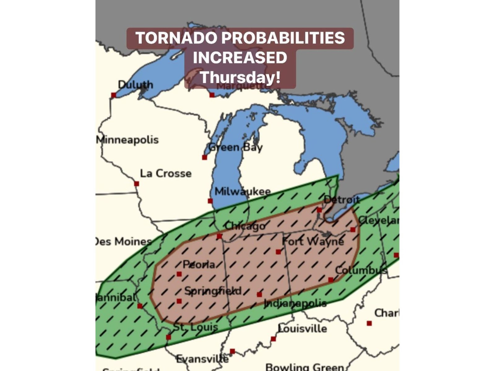
The latest outlook indicates a 5% tornado probability, including a hatched area signaling the potential for isolated significant tornadoes, a key concern for communities along the storm path.
Storm Setup Driving Thursday’s Tornado Risk
The elevated threat is being driven by a combination of unstable air and an advancing cold front, creating favorable conditions for supercell thunderstorms. These storms are expected to initiate near southern Lower Michigan, where atmospheric energy is strongest during the late afternoon hours.
As the storms organize, they will move southeastward, crossing into northern Indiana and brushing portions of northeastern Illinois, including areas near Chicago. This storm motion increases the risk window for multiple states rather than a single localized zone.
The presence of a hatched tornado area suggests that while overall probabilities remain moderate, conditions could support stronger, more organized tornadoes if storms intensify rapidly. This type of setup often brings fast-changing conditions, making real-time monitoring essential.
Areas Most at Risk Across the Midwest
The highest concern extends across a corridor that includes Chicago, Peoria, Springfield, Indianapolis, Fort Wayne, and Detroit, all falling within or near the outlined risk zones. The map highlights a broad swath stretching from central Illinois through northern Indiana into southern Michigan and western Ohio.
Cities like Chicago and Milwaukee sit near the northern edge of the risk area, where storms may still bring damaging winds, hail, and isolated tornado potential. Meanwhile, locations farther south, including Springfield and Indianapolis, lie closer to the core zone where storm intensity could peak.
This regional setup means that residents across multiple states should prepare for rapid weather changes between late afternoon and evening, especially as storms move quickly along the frontal boundary.
Timing and Storm Evolution to Watch
Storm development is expected to begin around 4–5 PM near southern Lower Michigan, with activity expanding and intensifying as it moves into Indiana and Illinois during the early evening hours. The most active window for severe weather will likely occur between 5 PM and 9 PM, depending on storm speed and organization.
As the storms track southeast, they may form discrete supercells initially, which are known for producing tornadoes and large hail. Over time, these could evolve into a more organized line of storms, increasing the threat of damaging winds across a wider area.
The key factor will be how quickly storms strengthen after initiation. If instability and wind shear align efficiently, the region could see brief but impactful severe weather events, including isolated tornado touchdowns.
What This Means for Chicago and Surrounding Areas
For the Chicago metro area, the threat appears to be conditional but notable, especially during the early evening hours. While not every location will see severe weather, the environment supports localized storm intensification, meaning some neighborhoods could experience strong storms while others remain unaffected.
Nearby regions in northern Indiana and southern Michigan may face a slightly higher risk, particularly along the projected storm track. Residents in these areas should remain alert for weather warnings and rapidly developing conditions.
Given the nature of supercell storms, impacts can occur quickly, often with limited lead time. This makes preparedness and awareness critical, especially for evening commuters and outdoor events.
As Illinois, Indiana, and Michigan prepare for Thursday’s evolving severe weather setup, staying informed will be key to navigating potential impacts. For continued updates on Midwest storm threats, severe weather alerts, and regional coverage, visit ChicagoMusicGuide.com.