
Illinois, Indiana, Missouri, Iowa and Wisconsin Face Monday–Tuesday Severe Storm Risk With All Hazards Possible Including Tornadoes and Large Hail
ILLINOIS, INDIANA, MISSOURI — A renewed severe weather threat is emerging across the Midwest as forecast models signal multiple rounds of storms returning on Monday night (March 30) and again on Tuesday (March 31), 2026. The latest outlook highlights Illinois and surrounding states as a key zone where all severe hazards could be in play once again.
This developing setup raises concerns for damaging winds, large hail, and potential tornadoes, especially as storm energy appears to increase heading into Tuesday.
Monday Night Setup Brings Initial Storm Risk Across Illinois and Nearby States
Forecast data for Day 4 (March 30) shows a growing severe weather probability zone centered over Illinois, eastern Missouri, and parts of Iowa and Wisconsin. While this initial round may be more scattered, it signals the beginning of a more active pattern developing across the region.
Storms Monday night could begin organizing as they track eastward, with hail and gusty winds likely the primary threats early on. However, even at this stage, conditions may allow for isolated stronger storms, depending on how much instability develops.
Areas including Chicago, Springfield, St. Louis, and surrounding communities should remain alert as storms begin to take shape after sunset.
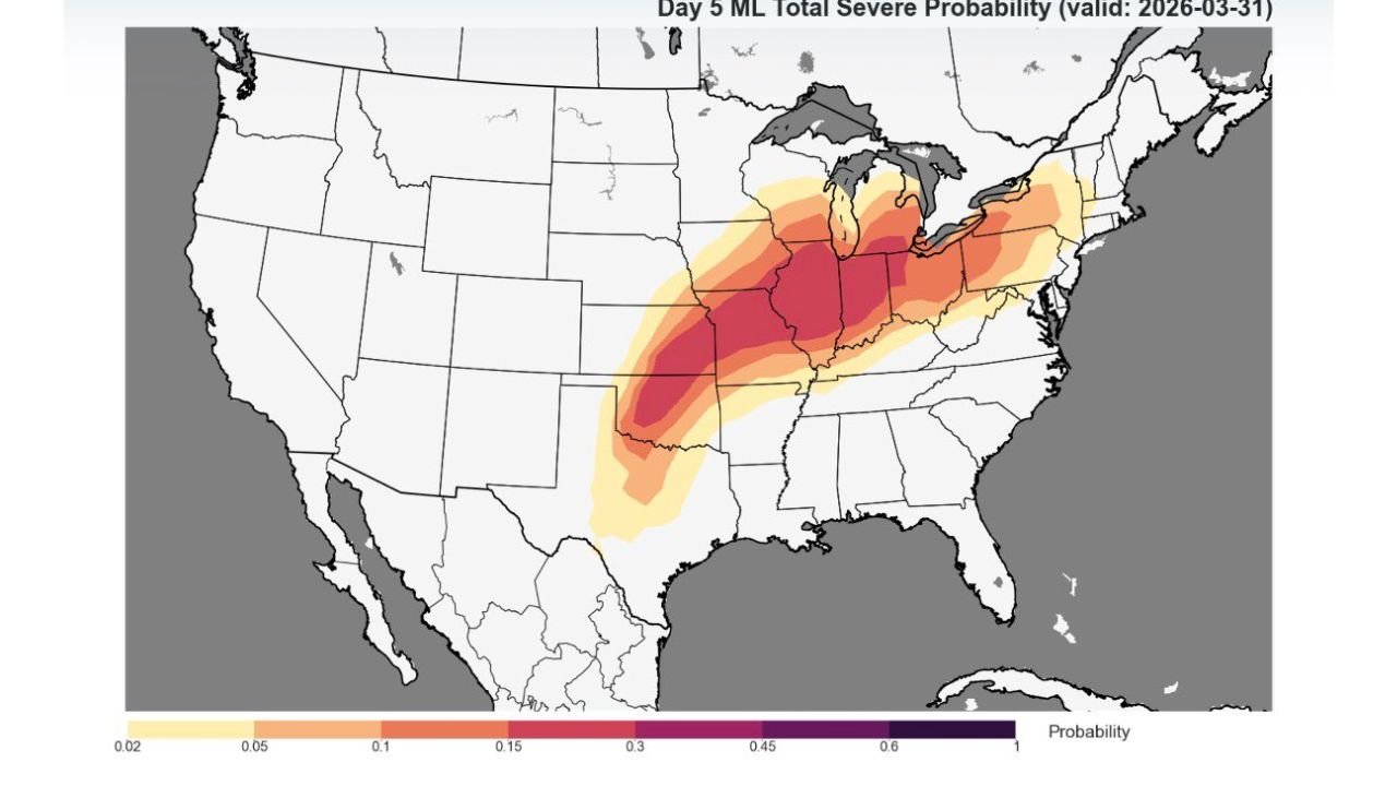
Tuesday Brings a More Widespread and Intensified Severe Threat
The Day 5 outlook (March 31) shows a much more concerning picture, with a broad corridor of higher severe probabilities stretching from Missouri and Illinois through Indiana and into parts of Ohio and Michigan.
This indicates a more organized and widespread severe weather event, with storms likely becoming stronger and more numerous. As atmospheric conditions become more favorable, all hazards—including tornadoes, damaging winds, and large hail—are expected to be possible.
The increasing coverage and intensity suggest that Tuesday could be the more impactful day, particularly for Illinois, Indiana, and surrounding Midwest states.
Why This System Could Become More Dangerous
This setup appears to be driven by a strengthening storm system interacting with warm, unstable air across the Midwest. As temperatures rise and moisture increases ahead of the system, storms will have more fuel to intensify.
Wind shear is also expected to increase, which is a key ingredient for organized severe storms and potential tornado development. The combination of instability, moisture, and wind dynamics creates an environment where storms can evolve rapidly.
If storms develop into clusters or lines, the damaging wind threat could become more widespread, while isolated supercells could still pose a tornado risk.
What This Means for Chicago and Local Events
For Chicago and the broader Illinois region, this pattern could impact evening events, travel, and outdoor activities across both Monday and Tuesday.
Concerts, live performances, and gatherings scheduled during these days may face weather-related disruptions, especially if storms intensify during peak evening hours.
Residents and event organizers should closely monitor updates as the situation evolves, since timing and storm intensity could still shift in the coming days.
As severe weather season ramps up across the Midwest, stay connected with ChicagoMusicGuide.com for timely updates on how major storms may impact concerts, festivals, and live music experiences across the region.