
Illinois, Indiana, Ohio and Kentucky Face Limited Severe Storm Risk Sunday as Strong Elevated Mixed Layer Caps Ohio Valley Atmosphere
OHIO VALLEY & MIDWEST — Forecasters are closely monitoring Sunday, March 22, for the potential of a few strong thunderstorms across parts of Illinois, Indiana, Ohio, and Kentucky, but new atmospheric data suggests a powerful limiting factor could keep the overall severe threat in check.
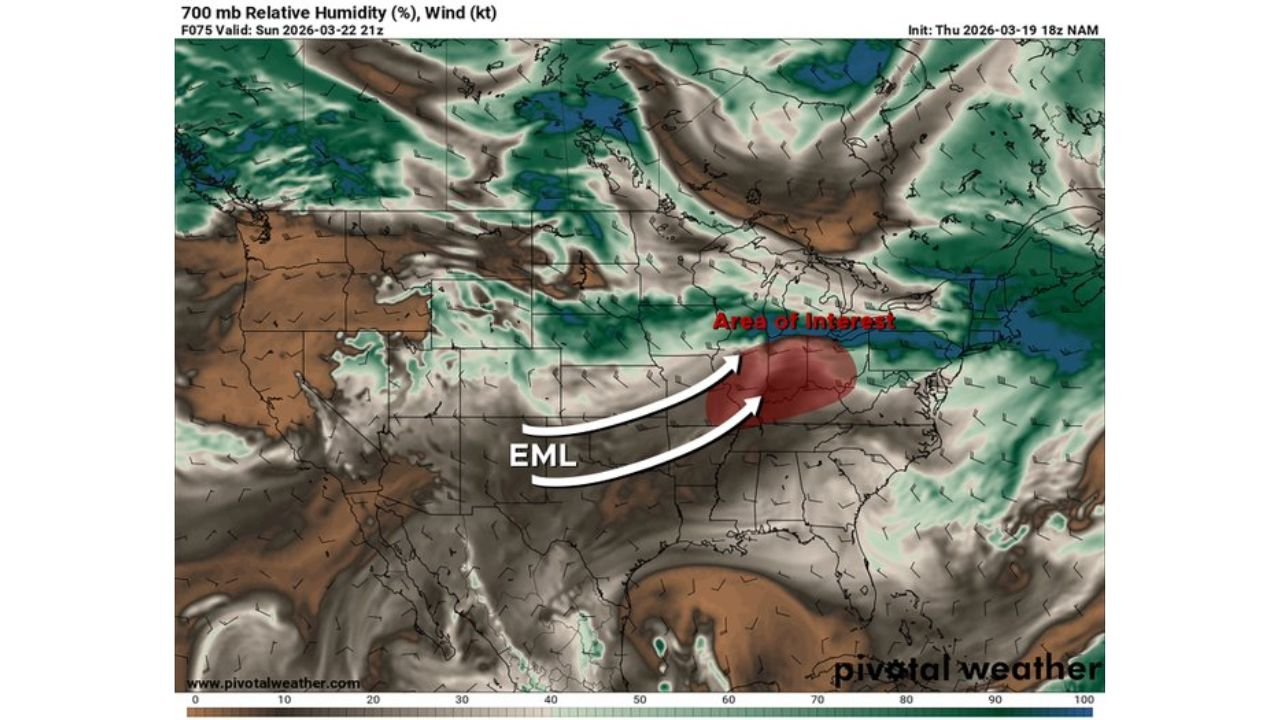
While conditions at the surface may appear primed for storm development, a strong Elevated Mixed Layer (EML) is expected to overspread the region, potentially suppressing widespread thunderstorm formation.
Area of Interest Centers on Illinois, Indiana and Ohio
Forecast guidance highlights the primary zone of concern stretching from:
- Central and southern Illinois
- Indiana (including Indianapolis and surrounding areas)
- Western and central Ohio
- Northern Kentucky
Upper-level wind fields show strong flow over the region, with enhanced mid-level energy moving into the Ohio Valley. This would typically support organized storm development.
However, the atmosphere is more complicated than it appears.
Strong Capping Layer Could Suppress Storm Growth
A pronounced EML (Elevated Mixed Layer)—characterized by very warm and dry air aloft—is forecast to move eastward from the Plains into the Midwest and Ohio Valley.
At roughly the 700 mb level, temperatures are projected to be unusually warm, creating what meteorologists call a “cap.” This cap acts like a lid on the atmosphere, preventing surface air parcels from rising freely.
Even if:
- Surface temperatures are very warm
- Low-level moisture is abundant
- Instability appears sufficient
The cap may prevent thunderstorms from initiating across much of the warm sector.
Upper-Level Dynamics Present but Surface Storm Initiation Uncertain
Mid-level maps show:
- Strong 500 mb winds overspreading Illinois, Indiana and Ohio
- Enhanced upper-level support
- Sufficient shear profiles for organized storms
Sounding data indicates favorable wind structure for rotating storms, but also clearly highlights the warm, dry air layer aloft bringing strong capping.
In many cases, severe weather requires a trigger—such as a strong front or upper-level disturbance—to break that cap. Current projections suggest that forcing may not be strong enough in many areas.
If Storms Break the Cap, They Could Be Strong
While the overall severe threat appears limited, any storm that manages to overcome the cap could quickly intensify.
If initiation occurs, possible hazards include:
- Strong wind gusts
- Isolated hail
- Brief severe thunderstorms
However, widespread severe weather appears unlikely unless the cap weakens more than currently projected.
Storm Risk Focused on Narrow Corridor
The highest probability for isolated stronger storms may be along:
- Parts of southern Illinois
- Southwestern Indiana
- Western Kentucky
Even there, coverage is expected to be limited rather than widespread.
Why the EML Matters
An Elevated Mixed Layer often forms over the High Plains and Southwest before being transported eastward. When it overspreads the Midwest:
- It increases instability potential
- But also creates strong capping
- Leading to either explosive storms or very few storms at all
In this case, the cap appears dominant.
Bottom Line for Sunday, March 22
A few strong thunderstorms remain possible across the Illinois–Indiana–Ohio–Kentucky corridor, but the presence of a robust EML significantly reduces the likelihood of a widespread severe outbreak.
Residents across the Ohio Valley should remain weather-aware, but current data suggests this setup may produce isolated strong storms rather than a major severe event.
Stay with ChicagoMusicGuide.com for continued updates as Sunday’s forecast evolves and additional model data refines the storm outlook.