
Illinois, Indiana, Ohio, and Kentucky See Strong Evening Thunderstorms as Cold Front Brings 40–60 MPH Wind Gusts
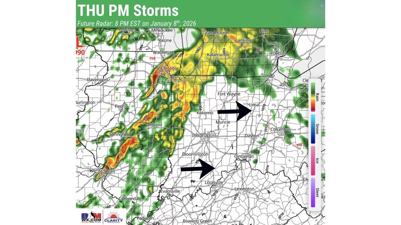
ILLINOIS — A fast-moving cold front is pushing east across the Midwest and Ohio Valley Thursday evening, triggering a narrow but intense line of thunderstorms from Illinois into Indiana, Ohio, and northern Kentucky. Forecast data shows storms strengthening briefly as they move east, with damaging straight-line winds emerging as the primary concern.
While the overall severe setup remains limited, the speed and structure of the storm line mean sudden wind bursts and localized impacts are possible as the front moves through.
Storm Timing Across the Region
High-resolution model guidance shows a clear west-to-east progression:
- Illinois: Early to mid-evening, including northern and central portions of the state
- Indiana: Mid-evening, affecting Indianapolis, Muncie, and surrounding areas
- Ohio and Northern Kentucky: Late evening into overnight, including Dayton, Columbus, and Louisville
Storms are expected to move quickly, reducing the risk of long-lasting impacts in any one location.
Main Threat: Damaging Straight-Line Winds
The atmospheric setup features strong winds aloft combined with limited instability, favoring short-lived but forceful wind gusts rather than organized severe storms.
Primary hazards include:
- Wind gusts of 40–60 mph
- Downed tree limbs and sporadic power outages
- Brief heavy rainfall and reduced visibility
- Difficult travel for high-profile vehicles
Why Widespread Severe Weather Is Not Expected
Despite strong wind shear, low instability is preventing storms from maintaining strength. Forecast analysis indicates storm updrafts are being disrupted quickly, limiting the ability for storms to intensify or rotate.
A brief, isolated tornado cannot be fully ruled out, but confidence remains low, and the overall tornado risk is minimal.
Radar Trends and Storm Structure
Radar and short-term model trends show:
- A linear storm mode along the cold front
- Storms weakening and redeveloping rapidly
- Strongest winds concentrated along the leading edge of the line
This supports expectations of scattered strong storms rather than a widespread outbreak.
Conditions Improve Overnight
As the cold front exits east late tonight, cooler and drier air will move in, ending thunderstorm activity and leading to quieter conditions heading into Friday.
If you’re tracking regional weather impacts or planning travel this evening, stay alert as storms move through quickly. For continued weather updates and regional coverage, keep following ChicagoMusicGuide.com.