
Illinois, Indiana, Ohio, and Michigan See Split Weekend Weather Setup With Rain South, Snow Showers North, and Gradual Moderation Ahead
ILLINOIS — Upper-air satellite and moisture-transport data shows a clear split weather pattern setting up across Illinois, Indiana, Ohio, and Michigan for the weekend, driven by strong jet-stream energy and contrasting air masses across the central and eastern United States.
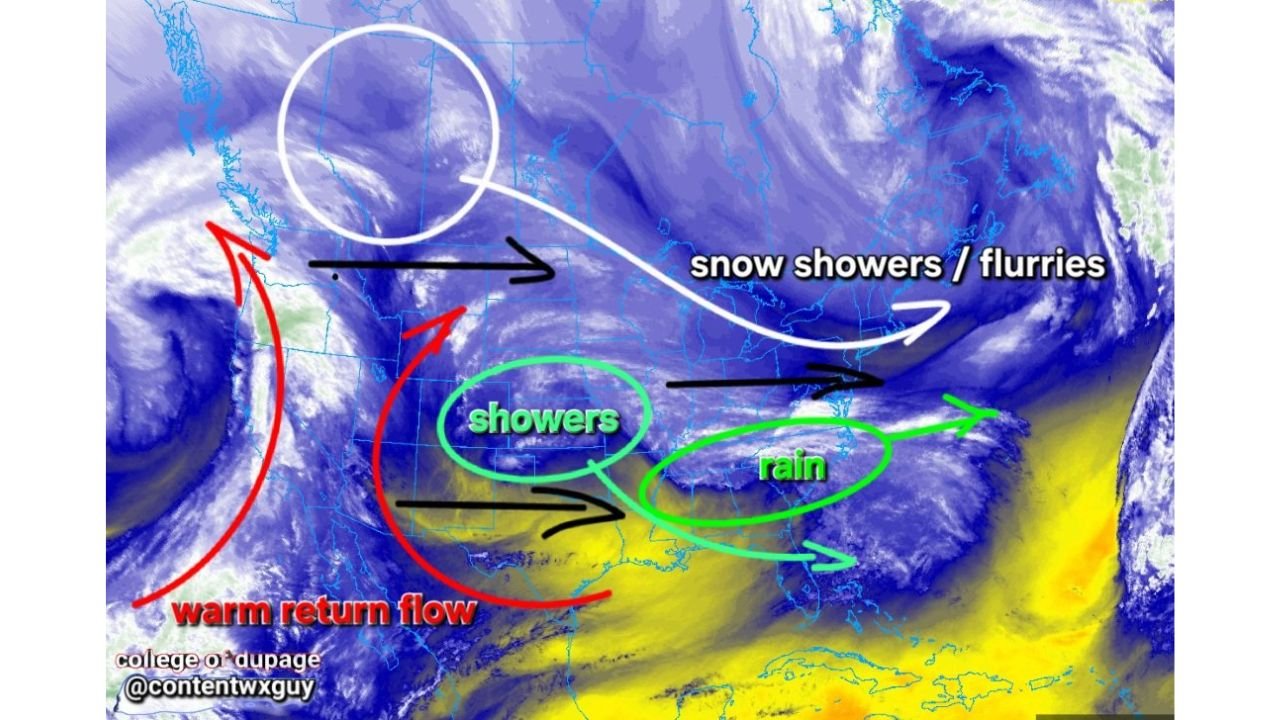
The data indicates no single dominant storm, but rather a divided setup where rain develops in warmer southern zones while snow showers and flurries persist across colder northern areas.
What the Data Shows About the Upper-Level Pattern
The imagery highlights a broad trough extending from the western U.S. into the Great Lakes, with fast-moving jet streaks controlling precipitation placement rather than a surface-based storm.
Key signals from the data include:
- Warm return flow lifting northward into parts of the Midwest
- Cold air locked in across the northern tier
- A jet-stream split allowing different precipitation types to exist side by side
This pattern explains why impacts vary sharply over short distances.
Rain Favored Across Southern Illinois, Indiana, and Ohio
The southern half of the region sits closer to the warm return flow, where temperatures remain above freezing.
Based on the data:
- Southern Illinois is positioned for rain showers
- Southern and central Indiana favor liquid precipitation
- Ohio, especially central and southern areas, also leans toward rain
Rainfall intensity appears light to moderate, with no signal for severe weather or flooding.
Snow Showers and Flurries Across Northern Illinois and Michigan
North of the thermal boundary, colder air dominates.
The data supports:
- Snow showers or flurries across northern Illinois
- Northern Indiana remaining on the colder side
- Much of Michigan staying cold enough for snow-type precipitation
Snow coverage looks scattered, not continuous, and accumulations appear limited, but brief visibility reductions are possible under heavier bands.
Why Conditions Improve After the Weekend
One of the most important takeaways from the data is what happens next.
The upper-level pattern shows energy lifting out after the weekend, allowing:
- Jet flow to relax
- Temperature moderation to begin
- Less aggressive cold intrusions early next week
This supports a transition phase, not a prolonged stormy or extreme setup.
Bottom Line Based on the Data
- Rain south, snow north — clear split
- No major storm system indicated
- Localized impacts, not widespread disruption
- Gradual moderation follows the weekend
This setup is driven entirely by upper-air dynamics, not surface cyclogenesis, which keeps impacts manageable but uneven across the states.
ChicagoMusicGuide.com will continue tracking these evolving atmospheric patterns. If you’re experiencing rain, flurries, or changing conditions in your area, stay alert for localized updates as this split pattern plays out.