
Illinois, Indiana, Ohio, Michigan and New York Brace for Late-March Arctic Blast as Winter Targets Great Lakes and Northeast with Snow and Sub-Freezing Wind Chills
CHICAGO, ILLINOIS — Just as spring attempts to gain traction across the Midwest and East Coast, new model guidance is signaling a powerful late-season cold shot between March 25 and March 29 that could drive winter conditions deep into the eastern half of the United States.
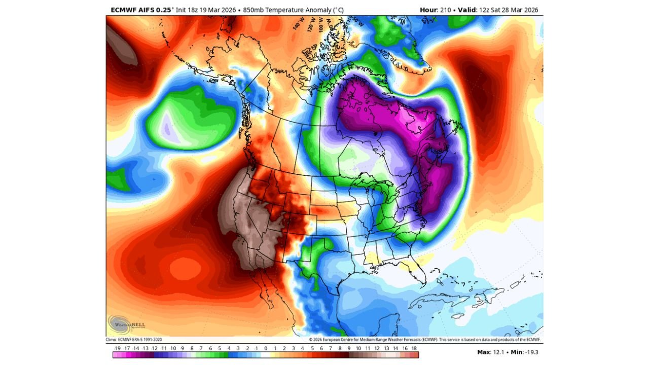
Forecast data shows a dramatic plunge of Arctic air diving south out of Canada, targeting the Great Lakes, Ohio Valley, Mid-Atlantic, and Northeast, with snow potential expanding across eastern Canada and northern New England.
Arctic Air Drops South into the Great Lakes and Ohio Valley
850mb temperature anomaly maps show a deep pool of much-below-normal air centered over Ontario, Quebec, Michigan, Ohio, Pennsylvania, and New York, with cold anomalies extending as far south as Kentucky, West Virginia, and possibly Tennessee.
For cities including:
- Chicago, Illinois
- Detroit, Michigan
- Cleveland and Columbus, Ohio
- Pittsburgh, Pennsylvania
- Buffalo and Albany, New York
Temperatures could run well below late-March averages, with daytime highs struggling and overnight lows dipping sharply.
Sub-Freezing Feel Extends into the Mid-South
Apparent temperature projections suggest wind-driven chill values could make it feel like winter even farther south.
Cold air may push into:
- Kentucky
- West Virginia
- Virginia
- Parts of Tennessee
While how far south the cold ultimately reaches remains uncertain, confidence is high that at least the mid-South and Ohio Valley will feel the impact.
Snow Focused on Eastern Canada and Northern New England
Snowfall projections show the heaviest accumulations across:
- Eastern Ontario
- Quebec
- Northern Maine
- Portions of New Brunswick and Nova Scotia
Bands of measurable snow may also clip northern sections of New York and interior New England, especially where lake enhancement or coastal interaction develops.
For the Great Lakes region, colder air over relatively warmer lake waters could enhance localized snow showers, particularly downwind of Lakes Superior, Michigan, Erie, and Ontario.
Chicago and the Midwest: A Late-Season Reminder
For Chicago and surrounding Illinois communities, this pattern suggests:
- A return to jacket-weather conditions
- Potential for brisk northwest winds
- Daytime highs below seasonal norms
While widespread heavy snow is not currently indicated for northern Illinois, the temperature drop alone will feel significant compared to recent mild spells.
Why This Pattern Matters
Late-March cold shots can:
- Damage early budding vegetation
- Disrupt spring planting schedules
- Create hazardous travel in snow-prone regions
This setup resembles a classic amplified North American pattern, with strong ridging in the western U.S. and a deep trough carving into the East — allowing Arctic air to spill southward.
Winter Not Done Yet
Although astronomical spring has begun, the atmosphere appears ready for one more aggressive surge of cold air across the eastern United States.
From Illinois and Michigan through Ohio, Pennsylvania, New York, and New England, residents should prepare for a brief but notable return to winter conditions between March 25 and March 29.
Stay with ChicagoMusicGuide.com for continued updates as model guidance refines snowfall totals, temperature ranges, and how far south this late-season Arctic blast ultimately travels.