
Illinois, Indiana, Ohio, Pennsylvania and New York Head Toward a Colder, Stormier Pattern as Arctic Air Returns Next Week
CHICAGO — After an unusually warm stretch that pushed temperatures far above normal across much of the Midwest and East Coast, winter is preparing to reassert itself. New atmospheric signals show arctic air rebuilding and sliding back into the eastern United States, setting the stage for a colder and potentially stormier pattern heading into the middle of January.
Meteorologists tracking large-scale trends say the current warmth is temporary, driven by a strong ridge that allowed mild Pacific air to dominate. That pattern is now weakening, opening the door for colder air to spill south and east.
Why the Pattern Is Shifting Back Toward Winter
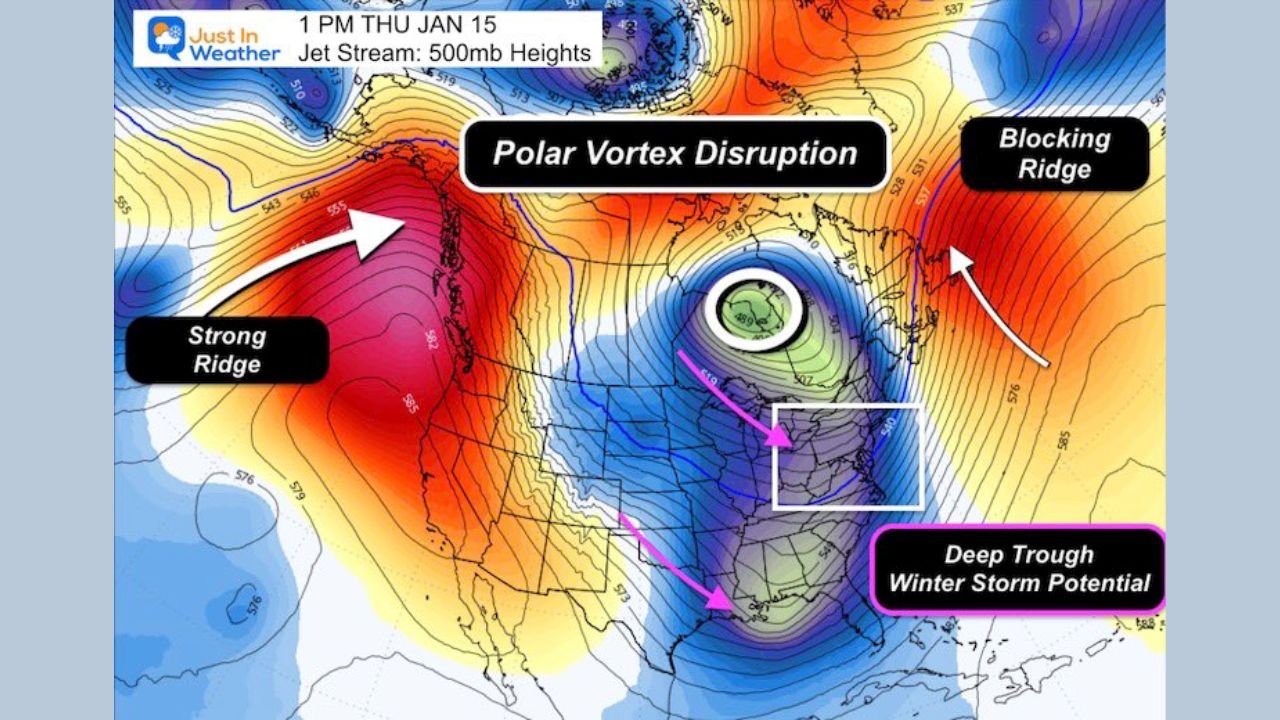
Forecast data shows a polar vortex disruption beginning to organize, supported by two major features in the upper atmosphere:
- A strong ridge developing off the Pacific Coast, forcing energy northward
- Blocking near Greenland in the North Atlantic, which helps slow weather systems and redirect cold air south
Together, these features help funnel arctic air back into the central and eastern U.S., reversing the recent warmth and restoring a more seasonal January setup.
What This Means for the Midwest and Great Lakes
For areas including Illinois, Indiana, and Ohio, temperatures are expected to trend closer to normal by Sunday before dipping below average next week. Overnight lows will turn noticeably colder, and daytime highs will struggle compared to recent record warmth.
While this shift does not guarantee immediate snow, it creates a favorable background pattern for winter systems to develop as cold air becomes re-established at the surface.
East Coast Could See a More Snow-Friendly Setup
Farther east, Pennsylvania and New York may benefit most from the evolving pattern. As cold air deepens and storm tracks slow, the environment becomes more supportive of coastal or inland winter storms, depending on how individual systems evolve.
Forecasters caution against locking in exact snow totals this far out, noting that storm timing and placement can still change. However, confidence is increasing that the overall pattern favors colder air and higher winter storm potential.
Why Forecasters Are Avoiding Long-Range Snow Maps
Meteorologists stress that while the pattern looks favorable, specific storm details more than a week away remain uncertain. Showing snowfall totals too early can be misleading, especially when small shifts in temperature or storm track can dramatically alter outcomes.
Instead, experts focus on the big picture — and right now, that picture supports a colder, more active winter regime returning.
Bottom Line
The January warmth is on borrowed time. As arctic air reloads and large-scale blocking takes shape, winter is expected to make a legitimate comeback across the Midwest and Northeast. Whether that leads to snow events will depend on individual systems — but the background setup is turning increasingly winter-friendly.
What do you think — is winter finally ready to take control again, or will this cold pattern fade just as quickly as it arrives? Share your thoughts and local conditions with us, and stay connected with ChicagoMusicGuide.com for continued updates on weather shifts, travel impacts, and how changing conditions could affect upcoming events across the Midwest and beyond.