
Illinois, Indiana, Ohio Under Level 3 Severe Risk as Chicago Region Faces Large Hail and Damaging Winds Thursday
ILLINOIS — A Level 3 severe weather risk has been issued for Thursday across Illinois, Indiana, and western Ohio, placing the Chicago region in a corridor where supercells could produce large hail exceeding 2 inches before transitioning into damaging wind storms by evening.
Forecast data shows storms developing during the late afternoon hours, with conditions becoming increasingly dangerous as they organize and move eastward across the Midwest.
Supercells Expected to Develop Across Illinois and Indiana
The primary concern begins with the formation of supercell thunderstorms, expected to develop across Illinois and Indiana during the late afternoon. These storms will form within a warm, unstable air mass, providing the energy needed for rapid intensification.
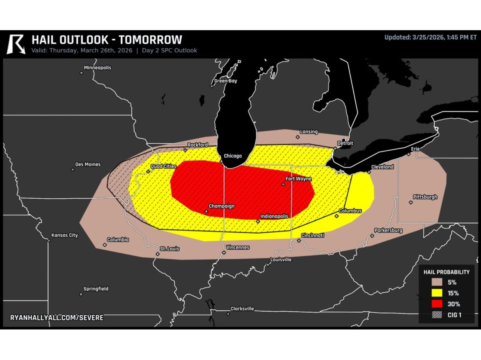
Areas including Chicago, Rockford, Champaign, and the Quad Cities sit within the zone where storms may first strengthen. As these supercells mature, they will be capable of producing very large hail, potentially exceeding 2 inches in diameter, posing risks to vehicles, buildings, and outdoor activity.
The presence of a 30% hail probability zone highlights the seriousness of this threat, especially across central and northern Illinois into central Indiana, where the most intense storms are expected to track.
Storms Transition Into Damaging Wind Event by Evening
As the evening approaches, these initial supercells are expected to merge into a larger line of storms, increasing the threat of widespread damaging winds. This transition often leads to storms becoming more organized, allowing impacts to spread across a broader area.
Cities such as Indianapolis, Fort Wayne, and Columbus are positioned along this evolving storm path, where the focus may shift from isolated hail-producing cells to fast-moving wind-driven storms capable of causing tree damage and power outages.
This progression from discrete storms to a line of storms is a key feature of Thursday’s setup, signaling a shift from localized intense impacts to more widespread severe conditions.
Chicago Region Positioned Near Core Risk Area
The Chicago metropolitan area sits near the northern edge of the highest risk zone, meaning it could experience both phases of the storm evolution. Early activity may bring isolated strong storms with hail, followed by a possible line of storms producing gusty winds during the evening hours.
Nearby locations in northern Indiana and southern Michigan may also see impacts, particularly as storms move east-southeast through the region.
While not every location will experience severe weather, the environment supports strong storm development, making it important for residents across Illinois, Indiana, and Ohio to remain alert throughout the day.
What Residents Should Expect Thursday
Thursday’s setup presents a multi-phase severe weather event, beginning with supercells capable of large hail and transitioning into a damaging wind event by evening. The combination of these threats increases the potential for disruptions during both late afternoon and nighttime hours.
The presence of a Level 3 risk indicates a higher likelihood of severe weather compared to typical days, meaning preparedness and awareness are critical, especially for those in the warm sector where storms will be most intense.
As storms track from Illinois into Indiana and Ohio, conditions may change quickly, with rapid storm development and shifting hazards across the region.
As the Midwest prepares for this elevated severe weather threat, staying informed will be essential for communities across Illinois, Indiana, and Ohio, including the Chicago region. For continued updates on severe storms, hail threats, and Midwest weather alerts, visit ChicagoMusicGuide.com.