
Illinois, Indiana, Tennessee and Arkansas Brace for Nocturnal Severe Storm Outbreak as 60–80 MPH Squall Line Targets Mississippi Valley Sunday Night
MEMPHIS, TENNESSEE — A potentially dangerous round of nocturnal severe storms is expected to erupt Sunday afternoon and intensify into the evening across the Mississippi Valley, placing portions of Arkansas, Tennessee, Illinois and Indiana in the path of a high-impact squall line capable of destructive winds and tornadoes.
Forecasters warn this will not be a typical spring thunderstorm setup. Instead, a powerful upper-air disturbance marked by a sharp dip in the jet stream will swing overhead, fueling rapid storm organization and strengthening a fast-moving line of severe weather.
Enhanced Risk Centered on Mississippi Valley Corridor
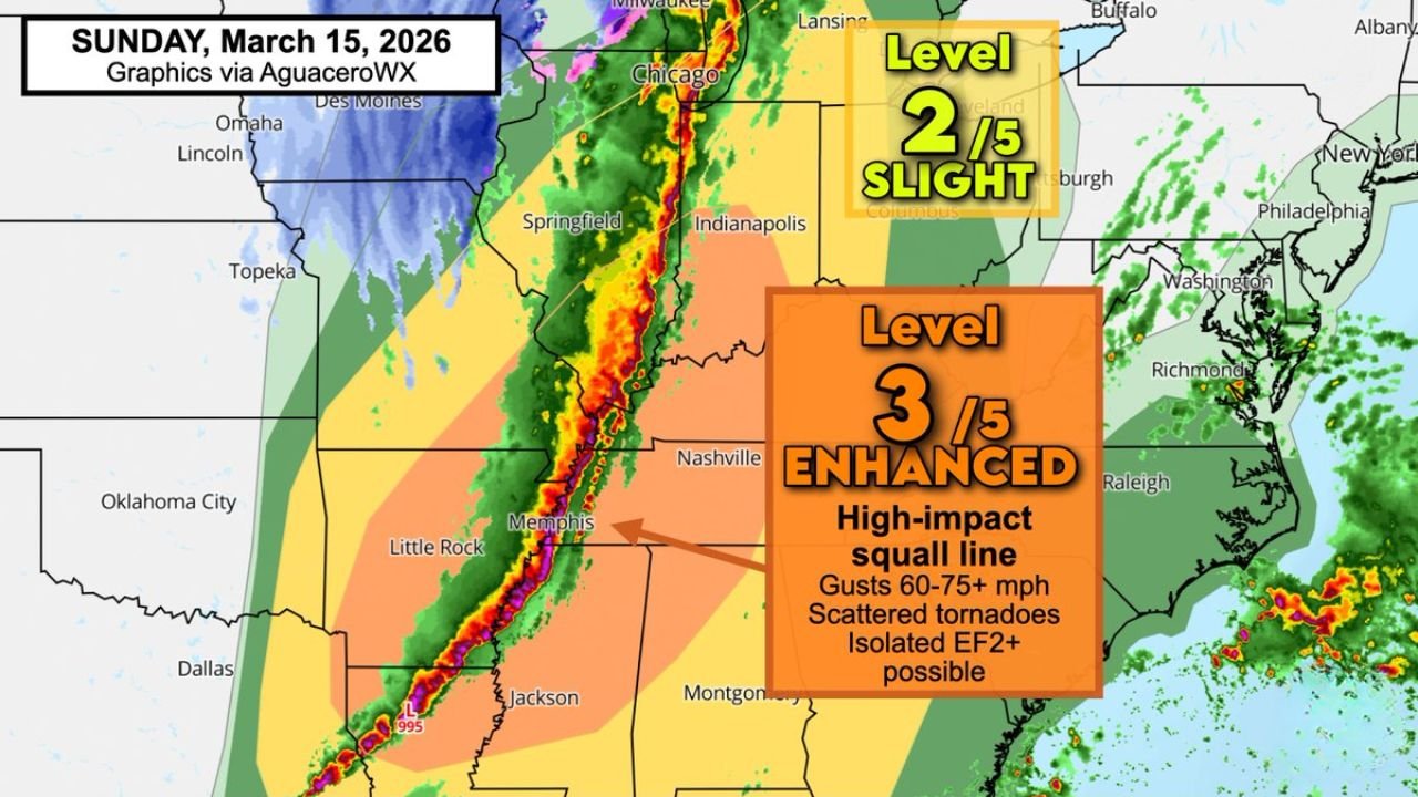
The Sunday, March 15 outlook highlights a Level 3 out of 5 Enhanced Risk stretching from eastern Arkansas through western and middle Tennessee into southern Illinois and southern Indiana.
Cities within or near the enhanced corridor include:
- Little Rock, Arkansas
- Memphis, Tennessee
- Nashville, Tennessee
- Jackson, Mississippi
- Evansville, Indiana
- Southern Illinois communities near the Mississippi River
A broader Level 2 Slight Risk extends north and east toward Indianapolis, Indiana and portions of Ohio.
Squall Line Expected to Develop in Arkansas
The severe line is forecast to initiate during the midafternoon across western Arkansas before rapidly filling in along the advancing cold front.
As the line strengthens, it will push northeast toward:
- Memphis during the evening
- Nashville after dark
- Southern Illinois and southern Indiana late evening into overnight
Much of the most dangerous activity is expected to occur after sunset, increasing the risk due to reduced visibility and sleeping residents.
60–80 MPH Winds and Tornado Risk
The primary hazard will be widespread damaging straight-line winds. Gusts between 60 and 80 mph are possible along the leading edge of the squall line.
Meteorologists note that the system will efficiently transport strong jet stream winds from higher altitudes down to the surface. That momentum transfer could result in destructive wind bursts capable of downing trees and causing power outages.
Scattered, quick-forming tornadoes are also possible — particularly along the leading edge of the line. An isolated stronger tornado, potentially EF2 or higher, cannot be ruled out.
One key concern is that tornadoes may form with little advance warning and may occur before heavy rain begins in some locations.
Highest Risk After Dark Near and East of Mississippi River
The timing suggests the most intense storms will move through near and east of the Mississippi River during nighttime hours.
That includes:
- Memphis, Tennessee
- Nashville, Tennessee
- Evansville, Indiana
- Southern Illinois river communities
Residents in these areas are urged to keep phones charged and weather radios active overnight.
Chicago Area Monitoring Northern Edge
While the highest impact zone remains to the south, Chicago, Illinois sits near the northern fringe of the broader storm system.
Heavy rain and strong winds are possible locally, though the most intense severe threat is currently projected to remain focused south of the city.
Preparation Is Critical
With storms expected after dark, preparedness becomes especially important.
Safety officials recommend:
- Keeping wireless alerts enabled
- Identifying a safe interior shelter location
- Charging electronic devices in advance
- Avoiding overnight complacency
This is shaping up to be a fast-moving, high-impact event across multiple states in the Mississippi Valley.
Stay with ChicagoMusicGuide.com for continuing updates as timing and intensity details become clearer heading into Sunday night.