
Illinois, Iowa and Missouri Severe Weather Threat Tuesday as Tornadic Supercells and Tennis Ball Size Hail Target Midwest Storm Corridor
ILLINOIS, UNITED STATES — A potentially active severe weather setup is expected Tuesday, March 10 across large parts of the Midwest, Corn Belt, Plains, and even portions of Texas, as a developing storm system creates conditions favorable for scattered to widespread severe thunderstorms. Forecast guidance suggests that tornado activity may develop in several areas, particularly where the atmosphere becomes unstable near a developing low-pressure system.
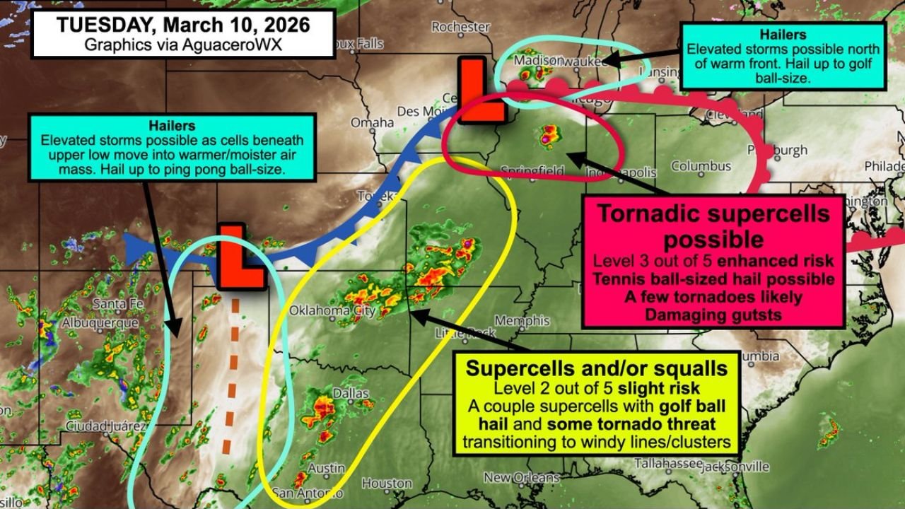
Meteorological analysis indicates that a surface low pressure system and advancing cold front will interact with warm, humid air moving northward toward Illinois and the Great Lakes, creating an environment capable of supporting supercell thunderstorms, damaging winds, large hail, and possible tornadoes.
Highest Tornado Potential Near Illinois, Iowa and Missouri
Forecasters are closely monitoring the region near the “triple point” of the storm system, where the cold front, warm front, and low-pressure center intersect. This area could become a focal point for rotating supercells capable of producing tornadoes.
Current projections place this zone across southeast Iowa, extreme northeast Missouri, and northern Illinois, where storms may develop during the afternoon and evening hours. Within this corridor, conditions could support tennis ball size hail and a few tornadoes, especially if storms remain isolated and organized before merging into larger clusters.
Cities within or near this risk area include Springfield in Illinois, parts of eastern Iowa, and areas near the Mississippi River valley.
Supercells and Windy Storm Lines Possible Southward
Farther south, a broader corridor stretching through much of Missouri, southeast Kansas, Oklahoma, and central Texas could also see scattered severe thunderstorms.
In these areas, storms may initially form as isolated supercells capable of producing large hail and a few tornadoes. However, forecasters note that storms may quickly transition into lines or clusters of thunderstorms, shifting the main threat toward damaging straight-line winds and heavy rain.
Cities such as Kansas City, Oklahoma City, Dallas, and Austin could see active weather during Tuesday as the system moves east.
Large Hail Possible North of the Warm Front
Another severe weather zone may develop across southern Wisconsin and parts of the upper Midwest, where storms could form north of the warm front in a cooler surface environment.
In this area, storms may become elevated above the surface layer, which can still produce significant hail events. Forecast guidance indicates hail sizes could reach ping pong ball to golf ball size if storms intensify in this environment.
Communities near Madison and Milwaukee in Wisconsin, along with nearby regions of the Great Lakes, may experience these elevated storm systems.
Storm System Driven by Strengthening Jet Stream and Moist Air
The severe weather threat is being driven by an approaching upper-level storm system and strengthening jet stream, which will help introduce wind shear throughout the atmosphere. Wind shear — changing wind speed and direction with height — is a critical ingredient for supercell formation and tornado potential.
At the same time, a large warm sector of humid air will expand northward across the Midwest, providing the energy needed for thunderstorms to rapidly intensify.
As the storm system progresses eastward Tuesday afternoon and evening, storms may develop across the Plains before expanding into the Midwest and Great Lakes regions.
Forecast Details Still Being Refined
While forecast confidence is increasing that severe weather will develop somewhere across the Midwest and Plains Tuesday, the exact locations of the strongest storms will depend on how the storm system evolves during the day.
Meteorologists will continue analyzing new model data to determine where the highest tornado and large hail threats will ultimately develop.
Residents across Illinois, Iowa, Missouri, and surrounding states should monitor updated forecasts and ensure they have ways to receive weather alerts if storms intensify Tuesday.
For continuing coverage of severe weather events and storm developments affecting the Midwest, readers can follow updates and detailed reports on ChicagoMusicGuide.com.