
Illinois, Iowa, Wisconsin and Michigan Face Increasing Tornado Risk Thursday as Warm Front Fuels Rotating Storms Near Chicago and Great Lakes
ILLINOIS, IOWA, WISCONSIN, MICHIGAN — A developing severe weather setup is raising concerns across the Midwest and Corn Belt this Thursday, with tornadoes expected to be a primary hazard, including the potential for an isolated significant EF2+ tornado. The setup centers around a lifting warm front, increasing humidity, and strong wind dynamics that could support rotating supercells near Chicago and across the Great Lakes region.
Warm Front Setup Creates Ideal Conditions for Severe Storm Development
The primary driver of this system is a warm front surging northward across Illinois, Indiana, and into Michigan, bringing a surge of warm, moist air into the region. This increasing humidity acts as fuel for thunderstorm development, especially when combined with an approaching low-pressure system over the central Plains.
As temperatures rise and instability builds, thunderstorms are expected to form along and near this boundary. The presence of a defined frontal zone will act as a focus point for storm initiation, particularly across northern Illinois, southern Wisconsin, and parts of Michigan.
This setup is especially concerning because storms forming along warm fronts often have access to enhanced low-level spin, increasing the chances for tornado development compared to typical storm environments.
Wind Shear and Atmospheric Dynamics Support Rotating Supercells
One of the most critical aspects of this event is the presence of strong wind shear, with southeasterly winds at the surface and powerful southwesterly winds in the mid-levels of the atmosphere. This change in wind direction and speed with height is a key ingredient for storm rotation.
Forecast data shows intense 500 mb winds overspreading the region, which will enhance storm organization and longevity. When combined with surface winds feeding into the warm front, this creates a favorable environment for supercells capable of producing tornadoes.
Near the low-pressure center tracking through Iowa into Wisconsin, atmospheric spin—also known as vorticity—will be particularly strong. This could allow 3 to 6 rotating supercells to develop, each with the potential to produce multiple tornadoes.
Two Key Tornado Risk Zones Identified Across the Midwest
Forecasters are highlighting two primary areas where the tornado threat could become most pronounced.
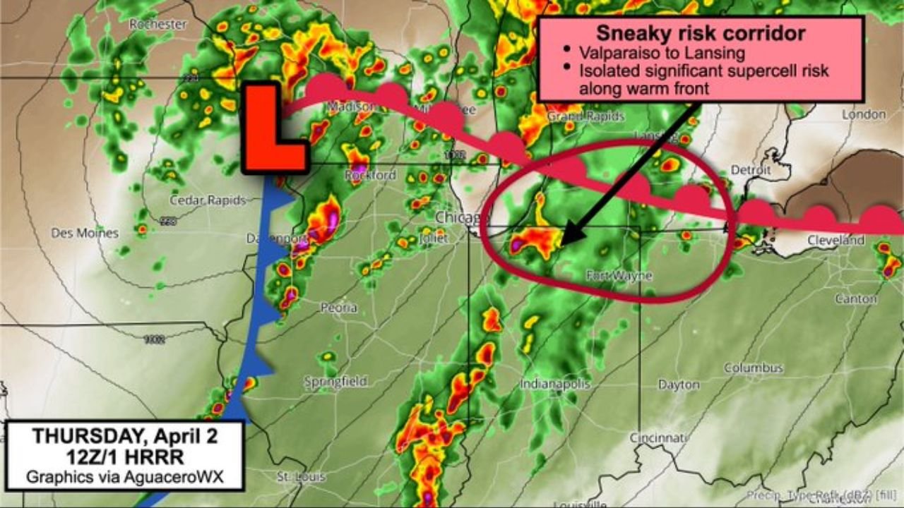
The first zone includes southern Michigan, particularly areas near Lansing and extending toward Detroit. Here, the interaction between the Great Lakes and cooler water temperatures may sharpen the warm front, creating a localized enhancement in storm intensity. This “sneaky risk corridor” could support isolated but potentially strong tornadoes, especially if the front lifts north at the right time.
The second, more significant zone stretches across Iowa, northwest Illinois, and southwest Wisconsin, including areas near Cedar Rapids, Davenport, Rockford, and Chicago’s western suburbs. This region sits closer to the low-pressure center, where wind dynamics are strongest and conditions are most favorable for organized supercell development.
In this corridor, storms could become more discrete, meaning they remain separated rather than forming a solid line. This increases the likelihood of longer-lived rotating storms capable of producing tornadoes, some of which could be stronger.
Timing and What Residents Should Expect Thursday
The severe weather threat is expected to develop through Thursday afternoon and intensify into the evening hours, aligning with peak heating and maximum instability. This timing increases the risk for rapid storm intensification, especially in areas along the warm front.
Residents across Illinois, Iowa, Wisconsin, and Michigan should prepare for rapidly changing weather conditions, including strong thunderstorms, damaging winds, large hail, and the potential for tornadoes. Areas near Chicago, Rockford, Madison, and Lansing should remain particularly alert as storms evolve.
Even though tornadoes may be isolated, the environment supports high-impact events where storms do develop, making preparedness critical across the region.
Why This Setup Is Particularly Concerning for the Midwest
What makes this system stand out is the combination of frontal boundaries, strong wind shear, and localized enhancements near the Great Lakes. These ingredients often lead to unexpected tornado development, especially in areas not typically considered high-risk.
The presence of both a warm front and a nearby low-pressure system increases uncertainty in storm placement but also raises the ceiling for potential severity. If storms align correctly with these features, the result could be intense, rotating thunderstorms capable of producing significant tornadoes.
As this severe weather setup unfolds across the Midwest, staying informed and prepared will be essential. For continued updates on storm threats, regional weather patterns, and breaking developments, visit ChicagoMusicGuide.com.