
Illinois, Minnesota, Wisconsin and the Northern Plains Brace for Mid-March Cold Shot as Temperatures Drop Below Normal March 12–17
UNITED STATES — After a stretch of springlike warmth across parts of the Midwest, forecast models indicate a notable colder air intrusion setting up between March 12 and March 17, targeting Illinois, Minnesota, Wisconsin, the Dakotas and the broader Northern Plains.
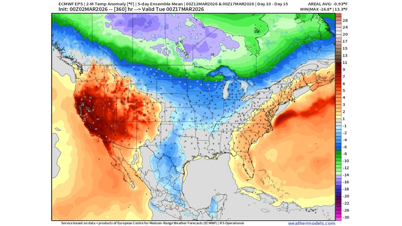
Ensemble temperature anomaly guidance shows below-average readings spreading across the central United States during this window, reinforcing the idea that winter is not quite finished.
Midwest Turns Cooler After Early Warmth
Temperature anomaly projections highlight:
- Illinois
- Iowa
- Minnesota
- Wisconsin
- North Dakota
- South Dakota
- Nebraska
running below seasonal averages during the March 12–17 period.
Blue shading across the Midwest signals departures several degrees below normal, while even colder anomalies deepen northward into southern Canada.
This suggests a brief but noticeable cold snap rather than an isolated overnight chill.
Upper Midwest and Northern Plains at Risk for Late-Season Snow
With colder air filtering southward, the pattern raises the possibility of:
- Late-season snow across the Upper Midwest
- Wintry weather chances in the Northern Plains
- Mixed precipitation potential in transitional zones
While specific storm systems are still uncertain, the thermal setup supports the idea that any organized precipitation during this window could fall as snow across northern-tier states.
Illinois and Chicago Outlook
For Illinois, including the Chicago area, this colder shot may mean:
- High temperatures trending below mid-March averages
- Overnight lows dipping closer to freezing
- A delay in consistent springlike warmth
Though no widespread major winter storm is confirmed at this range, the temperature signal suggests conditions will feel more March-like — or even late February-like — for several days.
Sharp Contrast Across the Country
The anomaly map shows a pronounced temperature divide:
- Western states, including California, Nevada, Utah and Arizona, running well above normal
- The Eastern Seaboard, including the Carolinas and parts of the Northeast, leaning warmer than average
- The Midwest and central U.S. caught in the cooler pocket
This kind of split pattern often results from upper-level troughing over the central U.S., allowing colder Canadian air to spill southward.
Agricultural Implications
The mention that “it will be a while before favorable planting conditions emerge” reflects the broader concern that soil temperatures may not warm consistently across parts of the Midwest.
For states like:
- Illinois
- Iowa
- Minnesota
lingering cool periods can slow early-season agricultural planning, especially if frost risks persist.
Bottom Line
A colder air mass is expected to move across Illinois, Minnesota, Wisconsin and the Northern Plains from March 12–17, bringing below-normal temperatures and the potential for late-season wintry weather in parts of the Upper Midwest.
While not a return to deep winter, the pattern reinforces that sustained spring warmth may still be a few weeks away.
ChicagoMusicGuide.com will continue monitoring this mid-March cooldown and provide updates as model confidence increases.