
Illinois, Missouri and Indiana See TORCON 5 Spike Tomorrow as Chicago, Peoria and St. Louis Face Highest Tornado Potential in Midwest Outbreak
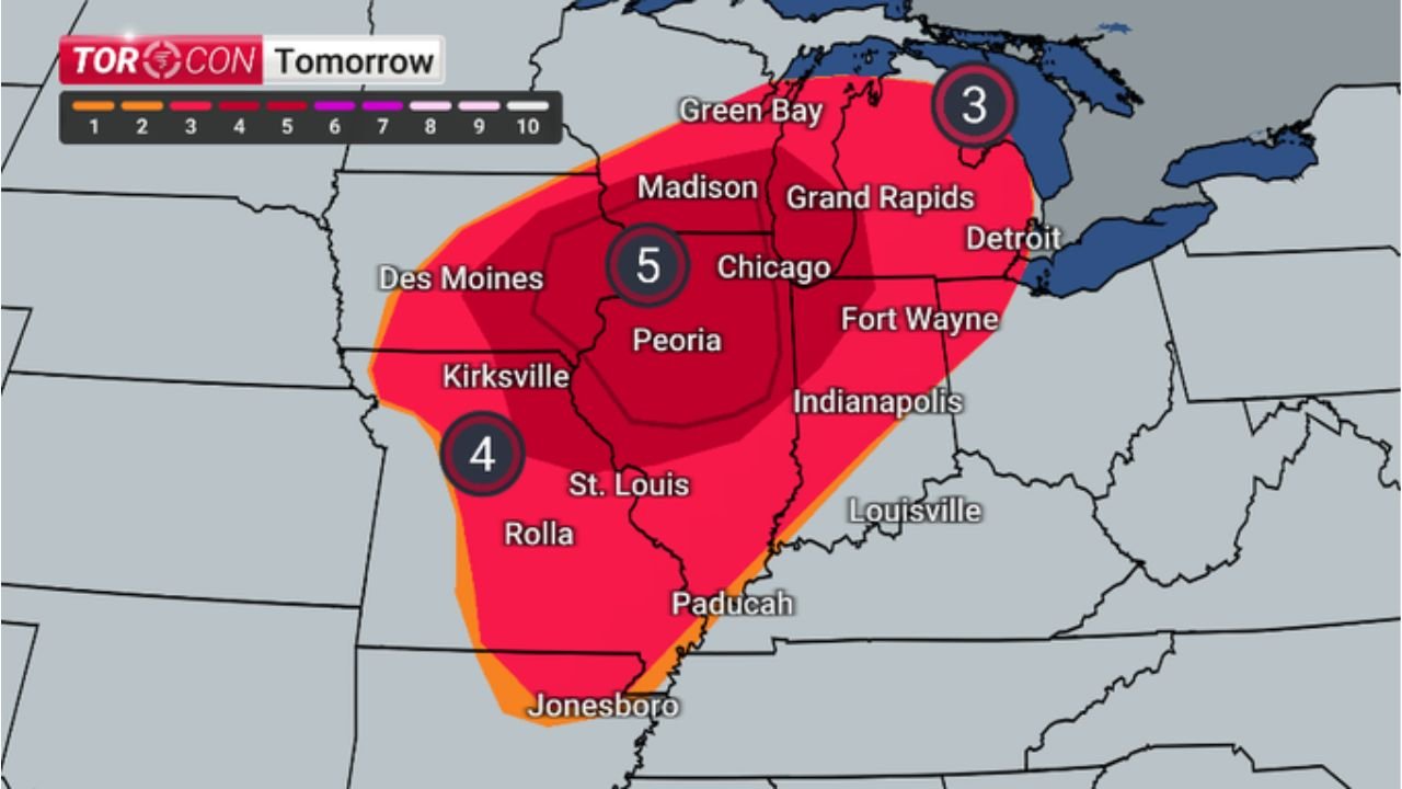
ILLINOIS, MISSOURI, INDIANA, WISCONSIN, MICHIGAN — Updated TORCON values are signaling a significant escalation in severe weather potential across the Midwest, with tomorrow’s outlook showing a TORCON 5 zone centered over Illinois, including areas near Chicago and Peoria. This level indicates a heightened probability of tornado development as a dynamic storm system moves through the region.
TORCON 5 Zone Centers on Illinois With Highest Risk Near Chicago and Peoria
The latest data places a TORCON 5—one of the higher levels on the tornado probability scale—directly over central and northern Illinois, extending into parts of eastern Missouri and western Indiana. Cities including Chicago, Peoria, and nearby communities fall within this elevated risk corridor.
A TORCON value of 5 suggests a notable chance of tornadoes forming within 50 miles of a location, especially when combined with favorable atmospheric conditions. This places Illinois at the core of the most concerning severe weather setup in the Midwest for the upcoming period.
Surrounding regions, including Des Moines, Kirksville, and St. Louis, are also within a TORCON 4 zone, indicating a strong likelihood of tornado-producing storms developing in these areas as well.
Storm System Expands Risk Across Indiana, Michigan and Wisconsin
The tornado threat is not limited to Illinois. The broader system extends eastward into Indiana, southern Michigan, and parts of Wisconsin, where TORCON values of 3 indicate a moderate but still impactful tornado risk.
Cities such as Fort Wayne, Indianapolis, Detroit, and Grand Rapids fall within this extended risk area, meaning rotating storms could track eastward and maintain strength as they move through the region.
Further north, areas near Green Bay and Madison also remain within the risk zone, although slightly lower compared to the core Illinois corridor. Even so, the presence of organized storm dynamics suggests that any storms that develop could still pose hazards including tornadoes and damaging winds.
Today’s Setup Shows Separate Tornado Risk Across Ohio Valley and Southern Plains
In addition to tomorrow’s Midwest threat, today’s TORCON outlook highlights two separate regions of concern.
Across the Ohio Valley, including Cincinnati, Huntington, Charleston, and parts of Kentucky, TORCON values around 3 indicate a moderate tornado risk. While not as intense as tomorrow’s setup, this region could still experience isolated tornadoes and strong storms, particularly during peak heating hours.
Meanwhile, across the Southern Plains, including Oklahoma City, Tulsa, Wichita Falls, and Abilene, a more focused corridor shows TORCON values reaching 4, with embedded areas of lower values near Fort Smith and Springfield. This suggests a more concentrated severe weather zone capable of producing tornadoes today, especially in Oklahoma and northern Texas.
Why This Midwest Setup Is Drawing Increased Attention
What makes tomorrow’s setup particularly concerning is the alignment of multiple severe weather ingredients, including instability, wind shear, and a well-defined storm track across Illinois and surrounding states.
The presence of a central low-pressure system moving through the Midwest will enhance atmospheric rotation, while warm, moist air surging northward will provide the fuel needed for storm development. This combination often leads to organized supercells, which are the primary drivers of tornado outbreaks.
The concentration of the highest TORCON values over densely populated areas like Chicago and central Illinois adds another layer of concern, as even isolated tornadoes could have significant impacts on communities and infrastructure.
What Residents Across the Midwest Should Prepare For
With TORCON values peaking at 5 in Illinois and remaining elevated across neighboring states, residents should prepare for rapidly developing severe weather conditions tomorrow. This includes the potential for tornadoes, damaging winds, and large hail, especially during the afternoon and evening hours.
Communities across Chicago, Peoria, St. Louis, Indianapolis, and Detroit should ensure they have multiple ways to receive warnings, including mobile alerts and local broadcasts. Identifying safe shelter locations and reviewing emergency plans will be critical as storms approach.
While not every location will see a tornado, the environment supports high-impact storms where they do form, making awareness and preparedness essential across the entire region.
As this evolving severe weather situation unfolds across the Midwest, staying updated with the latest forecasts will be key. For continued coverage of tornado risks, storm developments, and regional updates, visit ChicagoMusicGuide.com.