
Illinois, Missouri, and Ohio Face Marginal Severe Weather Risk With Gusty Winds and Isolated Storms Late December 28–29, SPC Warns
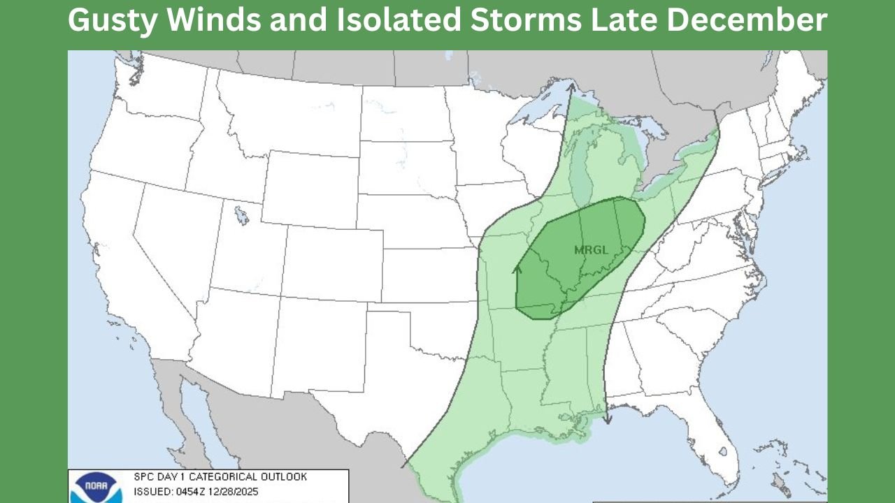
ILLINOIS AND MIDWEST — A developing storm system is prompting the Storm Prediction Center (SPC) to issue a Day 1 Marginal Risk for severe weather across a broad stretch of the central and eastern Midwest, extending from eastern Missouri through Illinois and into western Ohio. The outlook, valid late Sunday into early Monday, highlights the potential for isolated strong thunderstorms, primarily capable of producing gusty winds.
Forecasters emphasize that while widespread severe weather is not expected, the size of the risk area and overnight timing increase the importance of monitoring conditions closely.
Eastern Missouri to Illinois: Primary Impact Zone
The core of the marginal risk includes eastern Missouri and much of Illinois, where strengthening winds aloft and advancing frontal boundaries may allow a few thunderstorms to briefly intensify. The main concern in this zone is localized damaging wind gusts, especially with any storms that become organized along the cold front.
Rainfall may be heavy at times, and brief line segments could produce sudden wind surges, leading to downed tree limbs or isolated power interruptions. Storm coverage is expected to remain scattered, but impacts could be uneven and localized.
Ohio Valley Extension Into Western Ohio
The marginal risk area continues eastward into western Ohio, where storms are expected to weaken gradually as they progress overnight. Even so, forecasters caution that isolated strong wind gusts remain possible, particularly during the late-night to early-morning window when instability briefly overlaps with stronger wind fields.
The SPC notes that overnight timing may reduce storm intensity overall, but it also raises concern for people who may be asleep during peak activity.
Southern Extension Toward the Lower Mississippi and Tennessee Valley
The risk area also stretches southward into parts of the Lower Mississippi Valley and Tennessee Valley, where storms may develop along the same system. In these areas, gusty winds and locally heavy rain are the primary hazards, with limited potential for hail or tornado development.
Atmospheric conditions suggest storms will struggle to sustain severe intensity, keeping the overall threat limited but non-zero.
Why the Threat Is Classified as Marginal
A Marginal Risk indicates that severe storms are possible but expected to be isolated and short-lived. In this case, limited instability and nocturnal cooling should prevent widespread severe development. However, strong wind fields associated with the system mean that any storm that does organize could briefly become impactful.
The SPC stresses that marginal events can still produce damage, particularly when storms move quickly or catch communities off guard.
What to Watch Overnight
Residents across the affected corridor are advised to remain alert for rapid weather changes, especially during the overnight hours. Securing loose outdoor items, monitoring local alerts, and enabling weather notifications on mobile devices are recommended precautions.
As this storm system continues eastward and interacts with colder air farther north, it will also contribute to significant winter weather impacts elsewhere, highlighting the complex and wide-reaching nature of this late-December setup.
For continued updates on Midwest weather threats, storm outlooks, and developing conditions, visit ChicagoMusicGuide.com for ongoing coverage and analysis.