
Illinois, Ohio, Pennsylvania, New York, and New England Could See Renewed Snow Potential as Mid-January Pattern Evolves
PENNSYLVANIA — Long-range ensemble guidance continues to highlight an active and increasingly wintry pattern developing across the eastern half of the United States as mid-January approaches. While recent model runs have backed off on a clean interaction with the first round of upper-level energy, meteorologists note that this evolution may actually open the door for a second, potentially more impactful system as colder air becomes firmly established across the region.
Computer models now suggest temperatures could trend sharply colder between January 15 and January 20, setting the stage for snow chances to increase, particularly if later storm energy phases more efficiently with the cold air mass.
Ensemble Models Adjust Expectations for Early Energy
The latest GFS and ECMWF ensemble guidance shows reduced confidence in the first shortwave system producing a major winter event, as that feature appears more progressive and positively tilted. This limits its ability to slow down, deepen, or fully interact with surface cold air.
However, forecasters emphasize that this is not necessarily a negative signal for snow lovers. With the first system likely to miss or remain weaker, attention is shifting toward a second wave of energy trailing behind, which could encounter a colder and more favorable background pattern.
This type of evolution is common in mid-winter pattern transitions, where early systems act as setup features rather than the main event.
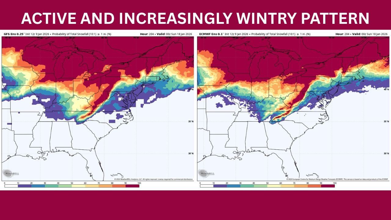
Snow Probability Maps Highlight Midwest-to-Northeast Corridor
Ensemble snowfall probability maps show a broad swath of elevated snow potential stretching from the central Midwest through the Ohio Valley and into the Mid-Atlantic and Northeast. While exact totals remain highly uncertain at this range, probabilities for at least one inch of snow increase notably across:
- Northern Illinois and Indiana
- Ohio and western Pennsylvania
- Upstate New York and interior New England
The sharp gradient on these maps underscores how sensitive outcomes will be to storm track. A shift of even 50 to 100 miles could dramatically alter who sees accumulating snow versus rain or mixed precipitation.
Upper-Level Pattern Favors Colder Eastern U.S.
Forecasts of 500mb height anomalies strongly support a deepening trough over the eastern United States, while a pronounced ridge builds across the West. This cold East, warm West pattern is a classic signal for sustained below-normal temperatures east of the Rockies.
For the Midwest and Northeast, this means any storm system that does develop will have greater access to cold air, increasing the likelihood that precipitation falls as snow rather than rain. The depth of the trough also raises the potential for storms to strengthen as they move northeastward.
This pattern is expected to persist for several days, increasing the odds that multiple systems could take advantage of the colder setup.
January 15–20 Window Remains the Key Focus
The January 15–20 timeframe continues to stand out as the most important window for potential winter weather impacts. Ensemble temperature trends suggest this may be when cold air bottoms out, particularly across the Great Lakes and Northeast.
Models are also hinting at multiple disturbances during this period rather than a single dominant storm. While this increases forecast uncertainty, it also raises the overall chance that at least one system could produce meaningful snow somewhere in the region.
Meteorologists caution that it is still too early to pinpoint specific cities or snowfall amounts, but confidence is growing that the pattern itself will be supportive of winter weather.
What This Means for Residents and Travelers
As mid-January approaches, residents across Illinois, Ohio, Pennsylvania, New York, and New England should be prepared for:
- Colder-than-normal temperatures
- Increased potential for snow or mixed precipitation
- Possible travel disruptions, especially during overnight or early-morning hours
- Rapid forecast changes as storm tracks become clearer
Those with travel plans or outdoor events during this period should remain flexible and monitor updates closely.
While the first round of energy may fall short of producing a major winter storm, the evolving pattern suggests the story is far from over. With colder air locking in and additional systems waiting in the wings, mid-January could still deliver impactful winter weather across large portions of the eastern U.S. For continued coverage of winter forecast trends, snowfall potential, and regional weather developments, visit ChicagoMusicGuide.com.