
Illinois Sees Temperatures Crash Up to 50 Degrees in 24 Hours as Arctic Cold Air Sweeps Across the State
ILLINOIS — A powerful surge of Arctic air has caused a dramatic temperature collapse across Illinois, with readings dropping as much as 50 degrees in just 24 hours, according to early-morning data Monday. The sharp cooldown followed a fast-moving cold front that swept across the Midwest overnight, bringing some of the most extreme short-term temperature changes of the season.
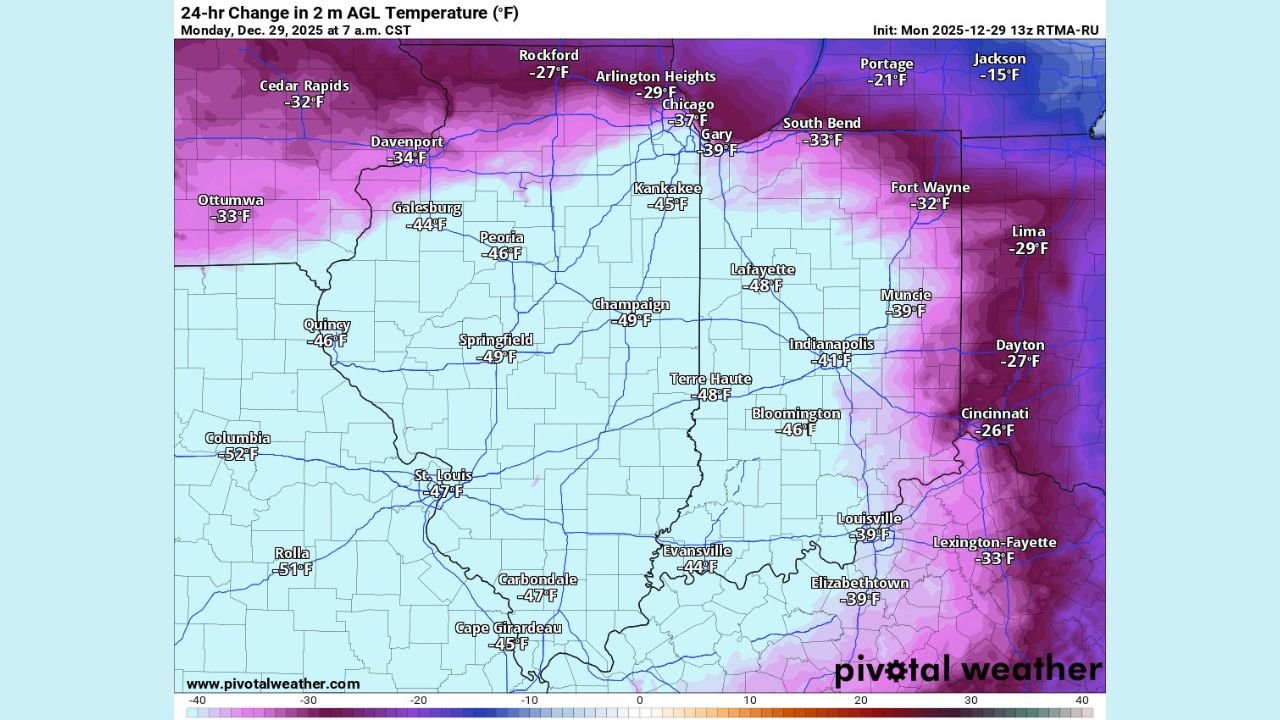
Chicago and Northern Illinois See Abrupt Overnight Crash
In the Chicago area, temperatures fell more than 35 degrees since Sunday morning. Downtown Chicago registered a 37-degree drop, while nearby Gary, Indiana fell nearly 40 degrees over the same period. Arlington Heights dropped close to 30 degrees, highlighting how quickly colder air poured south behind the front.
Northern Illinois experienced similar extremes, with Rockford dropping 27 degrees and surrounding communities plunging rapidly before sunrise. The speed of the change left little time for gradual adjustment, making the cold feel even more intense.
Central and Southern Illinois Hit Hardest
The most dramatic drops occurred farther south and west across the state. Data shows:
- Springfield: 49-degree temperature drop
- Champaign: 49-degree drop
- Peoria: 46-degree drop
- St. Louis metro area: roughly 47 degrees colder than 24 hours earlier
- Columbia, Missouri (near the Illinois border): more than 50 degrees colder
These readings indicate one of the steepest statewide temperature reversals Illinois has seen this season.
What Caused Such a Sudden Change
Meteorologists attribute the plunge to a strong Arctic air mass pushing rapidly south behind a cold front. The contrast between warm air ahead of the system and bitterly cold air behind it created ideal conditions for a fast and extreme temperature collapse.
Unlike slow-moving winter systems, this front advanced quickly, allowing cold air to replace warmth in just a few hours rather than over an entire day.
What to Expect Next
Temperatures are expected to remain well below recent levels, especially during overnight hours. Wind will add to the chill factor, making conditions feel even colder than the raw thermometer readings suggest. While no major snow totals are shown in the current data, the cold itself may affect travel, outdoor plans, and evening events.
Impact on Shows, Travel, and Outdoor Events
For concertgoers and music fans across Illinois:
- Dress for true winter conditions, especially for evening shows
- Expect slick spots on untreated roads as temperatures stay below freezing
- Allow extra travel time for late-night events
- Outdoor performances and queues will feel significantly colder than earlier in the weekend
While Illinois winters are no stranger to cold snaps, the speed and scale of this temperature drop make it stand out — and a reminder that winter weather can shift fast.
If you’re heading out to a show or planning events this week, stay warm, layer up, and keep an eye on local forecasts. For more updates that affect concerts, festivals, and nightlife across the Midwest, keep checking ChicagoMusicGuide.com.