
Illinois Snow Forecast Downgraded as Weak Midweek System Brings Just a Dusting to Two Inches, Not a Major Storm
CHICAGO, ILLINOIS — A weak weather system moving through Wednesday night into Thursday morning is expected to bring only a dusting to two inches of snow across Illinois, according to the latest model projections. Despite some social media chatter suggesting a larger winter storm, updated forecast data shows no signs of a major event for the state.
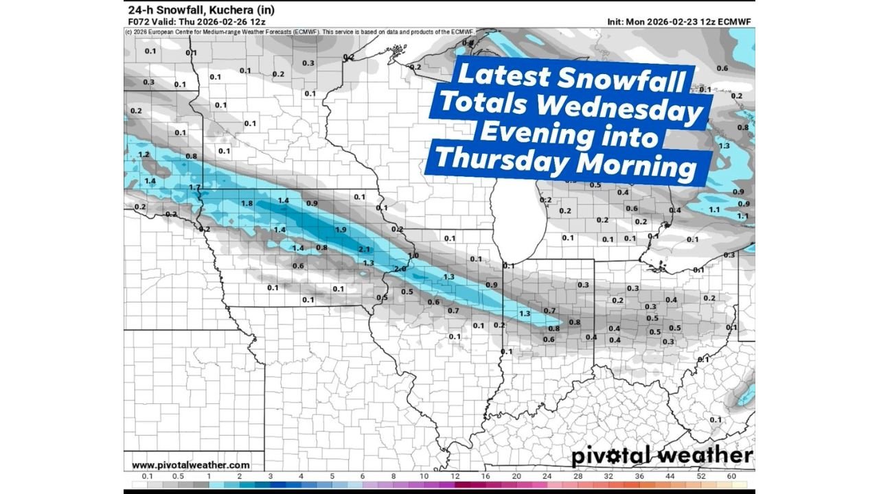
The latest 24-hour snowfall (Kuchera) guidance valid through Thursday at 12z indicates light accumulations across much of Illinois, with slightly higher totals confined to a narrow band across central portions of the state.
Narrow Band of Light Snow Across Central Illinois
Forecast maps show the highest accumulations — generally between 1.5 and 2.1 inches — stretching from western Illinois near the Mississippi River through parts of central Illinois and into eastern sections of the state.
Cities along this corridor could see close to 2 inches, particularly in localized spots where banding briefly strengthens.
However, this heavier stripe is narrow and not widespread. Most surrounding areas remain in the 0.1 to 1 inch range, signaling a light snowfall event overall.
Chicago and Northern Illinois See Minimal Impact
Across Chicago and much of northern Illinois, snowfall totals are expected to remain light, primarily in the dusting to half-inch range, with some localized areas nearing one inch at most.
The map shows very limited higher accumulation potential north of Interstate 80. This reinforces the message that northern parts of the state are unlikely to experience disruptive snow.
Commuters Thursday morning may encounter slick spots, but widespread travel impacts are not anticipated based on current projections.
Southern Illinois Stays Mostly Light
Further south into southern Illinois, totals generally fall under one inch, with several areas projected to receive only a few tenths of an inch.
The light gray shading on forecast graphics suggests minimal accumulation outside the central band. This supports the assessment that this is a minor winter system rather than a significant storm.
Why This Is Not a Major Winter Event
Meteorologists describe this as a weak, fast-moving system lacking the moisture and strong dynamics needed to produce heavy snow.
Key factors limiting totals include:
- Limited deep moisture supply
- Modest lift in the atmosphere
- Short duration of snowfall
Unlike previous high-impact winter storms, there is no strong low-pressure system intensifying over the Midwest, nor is there sustained banding capable of producing several inches statewide.
While snowfall maps can sometimes appear dramatic when viewed without context, current model guidance clearly supports a light event for Illinois.
What Illinois Residents Should Expect
For most of Illinois, this will be a quick-hitting snowfall Wednesday night, tapering by Thursday morning.
Residents should prepare for:
- Minor roadway slickness during the Thursday morning commute
- Light snow accumulation on grassy surfaces
- Little to no long-term disruption
There is no indication of widespread power outages, school closures, or major transportation interruptions at this time.
As always, small adjustments in storm track could slightly shift the narrow 2-inch band, but current data strongly supports a minor winter weather scenario.
Illinois has seen far more impactful winter systems this season. This midweek system simply does not compare in strength or coverage.
For continued updates on Illinois weather patterns, snowfall trends, and Midwest forecast changes, visit ChicagoMusicGuide.com.