
Indiana Snow Showers Target Kokomo and North-Central Counties With 1–3 Inches, Slick Roads Likely Into Thursday Morning
INDIANA — Snow showers are expected to ramp up this evening across north-central Indiana, with the most meaningful accumulation aimed at counties north of Indianapolis before the snow tapers off later overnight and into early Thursday.
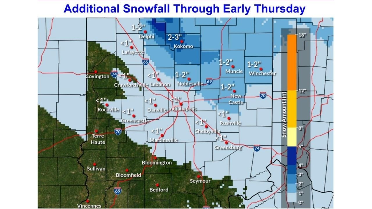
Forecast messaging highlights a 1–3 inch snowfall zone for far north-central counties, while much of the rest of central Indiana sees lighter, more scattered snow showers that may only manage a dusting up to around 1 inch.
What the latest setup looks like tonight
The expectation is for snow showers to focus over far north-central counties this evening, where most locations could land in the 1–3 inch range before activity fades overnight. Outside that main band, numerous flurries and scattered snow showers are still possible, but amounts are expected to be much lighter overall.
Several communities north and northeast of Indianapolis sit in the “steady enough to stick” zone, while areas closer to and just south of the metro are more likely to see lighter coatings.
Where the higher totals are most likely
A localized bullseye for heavier snow is shown near the Kokomo area, where totals are indicated in the 2–3 inch range. Surrounding pockets in north-central Indiana trend closer to 1–2 inches, including portions of the corridor running through and around communities such as:
- Lebanon
- Noblesville
- Muncie
- Winchester
- New Castle
Meanwhile, a broader region closer to Indianapolis and parts of central Indiana appear to lean toward lighter totals, often shown as under 1 inch in many spots. That’s still enough to create travel issues, especially if snow falls in bursts.
Why travel could get tricky fast
Even with “modest” totals for many areas, the bigger concern tonight is how quickly conditions can change during snow showers.
Hazard notes emphasize:
- Slick spots on untreated roads
- A chance of ice under a thin coating of snow
- Quick drops in visibility, especially north of Indianapolis
- Snow lingering long enough to cause trouble into Thursday morning
That combination matters because a thin layer of snow can hide icy patches, especially on bridges, overpasses, ramps, and less-traveled side streets.
Timing: when conditions worsen and when they improve
The most active window is expected this evening, with snow showers continuing and then tapering later overnight. The risk doesn’t instantly end when the snow ends, though—untreated and colder surfaces can stay slick into the Thursday morning commute, particularly in the north-central counties where totals are higher.
What drivers should do tonight and Thursday morning
If you’re traveling north of Indianapolis—especially through areas expecting 1–3 inches—plan as if roads will be partially snow-covered at times.
- Slow down early (not after you hit the first slick patch)
- Leave extra space between vehicles
- Watch for sudden visibility drops in heavier showers
- Treat bridges and ramps as icy first
- Give road crews room to work if you see plows or salt trucks
What this means for shows, rehearsals, and late-night plans
For anyone driving to midweek concerts, gigs, rehearsals, or late-night venues across central Indiana, the biggest issue isn’t a giant storm—it’s the possibility of fast-changing road conditions and surprise slick spots. If you’re heading out for an evening event, consider wrapping up earlier than usual, and if you’re traveling from Indianapolis toward the north-central counties, be prepared for a noticeable jump in accumulation as you get closer to the Kokomo-area band.
Have snow totals started stacking up where you live—especially north of Indy near Kokomo? Share what you’re seeing on the roads and how travel looks in your area in the comments, and keep following ChicagoMusicGuide.com for more Midwest weather updates that could impact your plans.