
Intense Lake-Effect Snow Band Slams Upstate New York With 5–6 Inches Per Hour Rates Near Lake Ontario
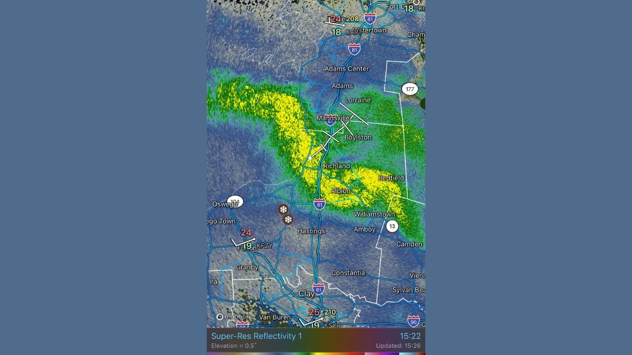
NEW YORK — A powerful and nearly stationary lake-effect snow band is hammering communities east of Lake Ontario this afternoon, producing extreme snowfall rates and rapidly deteriorating travel conditions across Oswego and Jefferson counties. Radar data shows reflectivity values nearing 40 dBZ, a signature commonly associated with 5–6 inches of snow per hour — some of the heaviest lake-effect rates the region sees.
A Highly Focused Snow Band Producing Dangerous Conditions
The latest high-resolution radar scans from KTYX Montague show a well-organized, intense band aligned from Mannsville and Boylston down through Albion, Richland, and Hastings, with heavy yellow shading indicating intense snowfall. Visibility has dropped sharply in these areas, and travel along I-81 from Adams Center to Parish has become hazardous.
On the ground, mapping imagery confirms that the heaviest snow corridor is locked in place, with traffic slowing significantly near Mexico, Maple View, and Pulaski as plows struggle to keep up with rapid accumulation.
Snowfall Rates Reaching 5–6 Inches Per Hour
The Ontario band is showing classic signs of high-impact lake-effect behavior:
- A narrow but highly efficient snow band
- Persistent fetch off Lake Ontario with strong convergence
- Reflectivity values near 40 dBZ, indicating deep, moisture-rich clouds
- Strong lift capable of producing rapid accumulation
Communities caught under this band could see several inches of snow in a very short period of time, with localized totals potentially exceeding one foot if the band remains stationary.
Travel Impacts Expanding Along I-81 and Nearby Roads
Drivers in towns such as Mexico, Selkirk Shores State Park, Port Ontario, Richland, and Amboy are experiencing rapidly changing conditions — clear roads turning snow-covered within minutes as the heaviest bursts pass overhead. Even short trips may be difficult as blowing and drifting snow reduces visibility.
State officials often note that lake-effect bands of this intensity can create “whiteout zones” only a few miles wide but extremely dangerous for anyone traveling through them.
Why This Band Is So Intense Today
A combination of factors is enhancing snowfall:
- Very cold air aloft moving across relatively warmer Lake Ontario
- Strong directional shear focusing the band into a narrow corridor
- Deep moisture profiles allowing snow to grow efficiently
- Long over-water fetch increasing lift
These ingredients often lead to the type of extreme snowfall rates now being observed.
What Residents Should Expect Next
Snowfall intensity may fluctuate, but the band is expected to remain active through the afternoon. Areas directly under the heaviest core — especially Mannsville, Boylston, Richland, and Mexico — should prepare for:
- Rapid snow accumulation
- Near-zero visibility in bursts
- Hazardous travel on all major and secondary roads
- Difficult snow removal if the band persists for multiple hours
Neighbors just a few miles away may see dramatically lighter amounts, which is typical of tightly focused lake-effect events.
Stay Updated With ChicagoMusicGuide.com
Weather patterns like this can shift quickly, especially around the Great Lakes. Stay with ChicagoMusicGuide.com for continued coverage, updated radar snapshots, and real-time analysis as this intense lake-effect band evolves.
Have you experienced conditions under a lake-effect band like this? Share your story or snowfall totals on ChicagoMusicGuide.com.