
Iowa and Northern Illinois Face Growing Concern for Severe Weather Outbreak Tuesday With Tornadic Supercells and Large Hail Possible
IOWA, UNITED STATES — Forecast models are increasingly signaling the potential for a significant severe weather event on Tuesday across parts of the central United States, with particular concern focusing on Iowa and northern Illinois. Meteorological guidance suggests the atmosphere may become favorable for strong thunderstorms capable of producing tornadoes, large hail, and damaging winds as a developing storm system moves across the Midwest.
Several model runs continue to highlight this region as a possible focal point for severe storm development Tuesday afternoon and evening, prompting forecasters to urge residents to closely monitor updates over the coming days.
Northern Illinois and Southeast Iowa Could See Tornadic Supercells
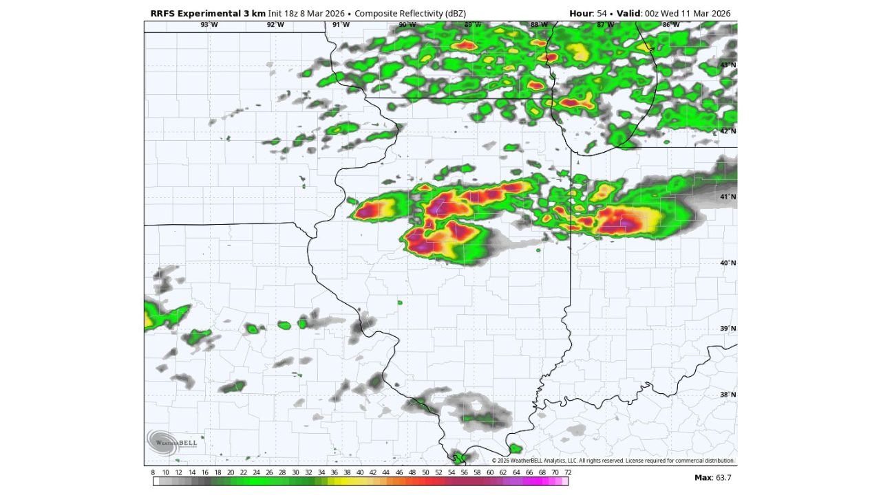
Forecast analysis points to an area near the triple point of a developing low pressure system as the most favorable location for rotating thunderstorms. This area may develop across southeast Iowa, extreme northeast Missouri, and northern Illinois, where atmospheric conditions could support isolated supercells capable of producing tornadoes.
If storms remain discrete before merging into larger clusters, they may produce large hail possibly reaching tennis ball size, along with a few tornadoes and damaging wind gusts.
Cities such as Chicago, Rockford, and Springfield in Illinois, along with parts of southeast Iowa, could fall within the region where storms become most intense during the late afternoon and evening hours.
Storms May Form Along Developing Cold Front
The severe weather threat is tied to an approaching low pressure system dragging a cold front eastward across the Plains and Midwest, while a warm front attempts to lift north toward the Great Lakes region including Chicago and Detroit.
As warm, humid air spreads northward ahead of the system, the atmosphere will become increasingly unstable. At the same time, a strengthening jet stream will introduce wind shear into the environment, an important ingredient for rotating supercell thunderstorms.
Storms could begin forming along the front during the afternoon before organizing into clusters or lines later in the evening.
Large Hail and Damaging Winds Also Possible
In addition to tornado potential, the storm system may bring very large hail and strong wind gusts to parts of the Midwest.
Large hail events are possible if storms intensify quickly within the unstable air mass. Forecast guidance suggests that hailstones ranging from golf ball size to potentially larger could occur in the strongest storms.
Damaging straight-line winds may also develop if storms evolve into organized storm lines moving east across Illinois and neighboring states.
Forecast Confidence Increasing But Details Still Evolving
While confidence is increasing that severe weather will develop somewhere across the central United States on Tuesday, meteorologists caution that the exact location of the most intense storms may shift as new forecast data becomes available.
Small changes in the position of the warm front, cold front, or developing low pressure center could shift the highest tornado threat either farther north or south across the region.
Residents across Iowa, northern Illinois, and surrounding Midwest states are encouraged to stay updated on the latest forecasts and ensure they have ways to receive severe weather alerts if storms intensify.
For continued coverage of severe weather events across the Midwest and updates affecting Chicago and northern Illinois, readers can follow the latest forecasts and reports on ChicagoMusicGuide.com.