
Iowa Blizzard Threat Intensifies as 60 mph Winds Target the State: Models Show Dangerous Whiteout Conditions Developing Tuesday Night
IOWA — A powerful wind event is developing across Iowa, with new high-resolution model guidance showing widespread wind gusts between 50 and 60 mph late Tuesday night into Wednesday morning. The setup, combined with roughly six inches of existing snowpack across northern Iowa, has prompted meteorologists to warn that blizzard-like conditions may emerge even without new snowfall.
A Winter Storm Watch has already been issued for large portions of north-central Iowa. Forecasters say wind intensity alone is enough to create ground blizzards, dangerous whiteouts, and drifting snow that could severely impact travel.
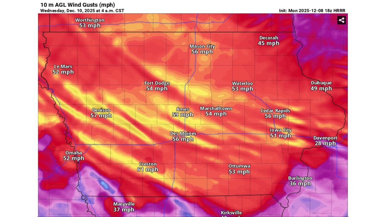
High-resolution HRRR model data from the Monday evening run shows gusts peaking between 56 and 61 mph across a broad swath of the state, especially near Ames, Des Moines, Creston, Fort Dodge, and Mason City.
Forecast Models Show Widespread 50–60 mph Gusts Across the State
Wind projections from the HRRR highlight just how widespread and intense the gusts may become:
- Ames: 59 mph
- Creston: 61 mph
- Denison: 57 mph
- Des Moines: 56 mph
- Mason City: 56 mph
- Fort Dodge: 54 mph
- Waterloo: 53 mph
- Cedar Rapids: 56 mph
- Iowa City: 51 mph
- Dubuque: 49 mph
Even areas farther south — which received less snow — are expected to see winds over 50 mph, raising concerns about dangerous crosswinds, semi-truck blowovers, and travel disruptions on open highways.
Why Blizzard Conditions Are Possible Without New Snow
Meteorologists emphasize that this is not a classic blizzard setup involving heavy snow. Instead, the system leverages:
- Existing snowpack that is light and powdery
- Long-duration wind gusts approaching 60 mph
- Dry air capable of lofting snow easily off the ground
This combination significantly increases the likelihood of zero-visibility whiteouts across rural highways.
Even a thin blanket of dry snow can lead to:
- Ground blizzards
- Complete loss of visibility in open areas
- Rapidly drifting roadways
- Dangerous and unpredictable travel conditions
Much of the northern tier of Iowa already has around 6 inches of snow, making the state especially vulnerable.
Travel Could Become Dangerous Early Wednesday
The peak period of concern runs from late Tuesday night through early Wednesday morning, particularly between 2 a.m. and 10 a.m. CST, when wind gusts are expected to be strongest.
Authorities warn of:
- Sudden whiteouts on rural roads
- Reduced visibility for commuters
- Blowing and drifting snow that may make roads impassable
- Possible delays or cancellations for early-morning travel
Motorists — especially commercial truck drivers — should prepare for hazardous crosswinds along Interstates 35, 80, and 29.
What’s Next for Iowa Weather?
Forecasters will continue monitoring the evolving wind field and pressure gradient as the system strengthens. Further advisories or warnings may be issued as confidence grows in the potential for dangerous blizzard-like conditions.
Residents are urged to:
- Avoid unnecessary travel during peak winds
- Prepare for rapidly deteriorating road conditions
- Stay updated with National Weather Service alerts
- Secure outdoor items that could become airborne
Stay Connected with ChicagoMusicGuide.com
For continued updates on Midwest winter weather, storm alerts, and regional conditions affecting travel and safety, stay with ChicagoMusicGuide.com for the latest information.