
Iowa, Illinois, Indiana and Missouri Face a Very Significant Severe Weather Day Thursday April 2 With Strong Tornadoes on the Table if Skies Clear in Time Across the Chicago, Des Moines and Indianapolis Corridors
CHICAGO, IL — Thursday April 2nd is shaping up to be one of the most significant severe weather days the Midwest has seen this spring — and the latest outlook update issued March 31, 2026 at 5:02 PM ET is now placing a Slight Risk zone directly over Chicago, Milwaukee, Des Moines, Springfield IL and Indianapolis. But the data supporting this setup goes well beyond a routine Slight Risk. If the atmosphere cooperates with one critical condition on Thursday morning, strong tornadoes are explicitly on the table across Iowa, Missouri and Illinois — making this a day that every resident from Kansas City to Detroit needs to take seriously before going to sleep tonight.
The One Variable That Determines Everything on Thursday
Unlike many severe weather setups where the threat is relatively straightforward, Thursday’s outcome hinges heavily on a single atmospheric variable — and understanding it is the key to understanding why this day carries so much potential.
Early-day convection — thunderstorm activity that fires during the morning and early afternoon hours — can leave behind a layer of cloud cover, outflow and stabilized air that acts as a cap on afternoon storm development. If that early activity lingers and keeps the atmosphere cloudy and stable heading into the prime afternoon heating hours, Thursday’s severe weather potential gets suppressed. Storms struggle to initiate, the instability never fully releases and the day ends up being less significant than the setup suggests.
If that early convection clears out fast enough — allowing sunshine to heat the surface, destabilize the atmosphere and allow Gulf moisture to mix up to the surface — the result is a completely different day. Discrete supercell thunderstorms would fire across Iowa and Missouri during the afternoon, tapping into an environment loaded with instability and wind shear. Those supercells would then move east through the afternoon and evening, tracking through Illinois, Indiana and into the Great Lakes corridor.
In that scenario — the one where the morning clouds clear and the afternoon atmosphere fully destabilizes — strong, long-track tornadoes are explicitly on the table across this corridor. Not spin-up tornadoes from a squall line. Not brief, weak touchdowns. Organized, potentially significant tornadoes from discrete supercells moving through one of the most densely populated corridors in the United States.
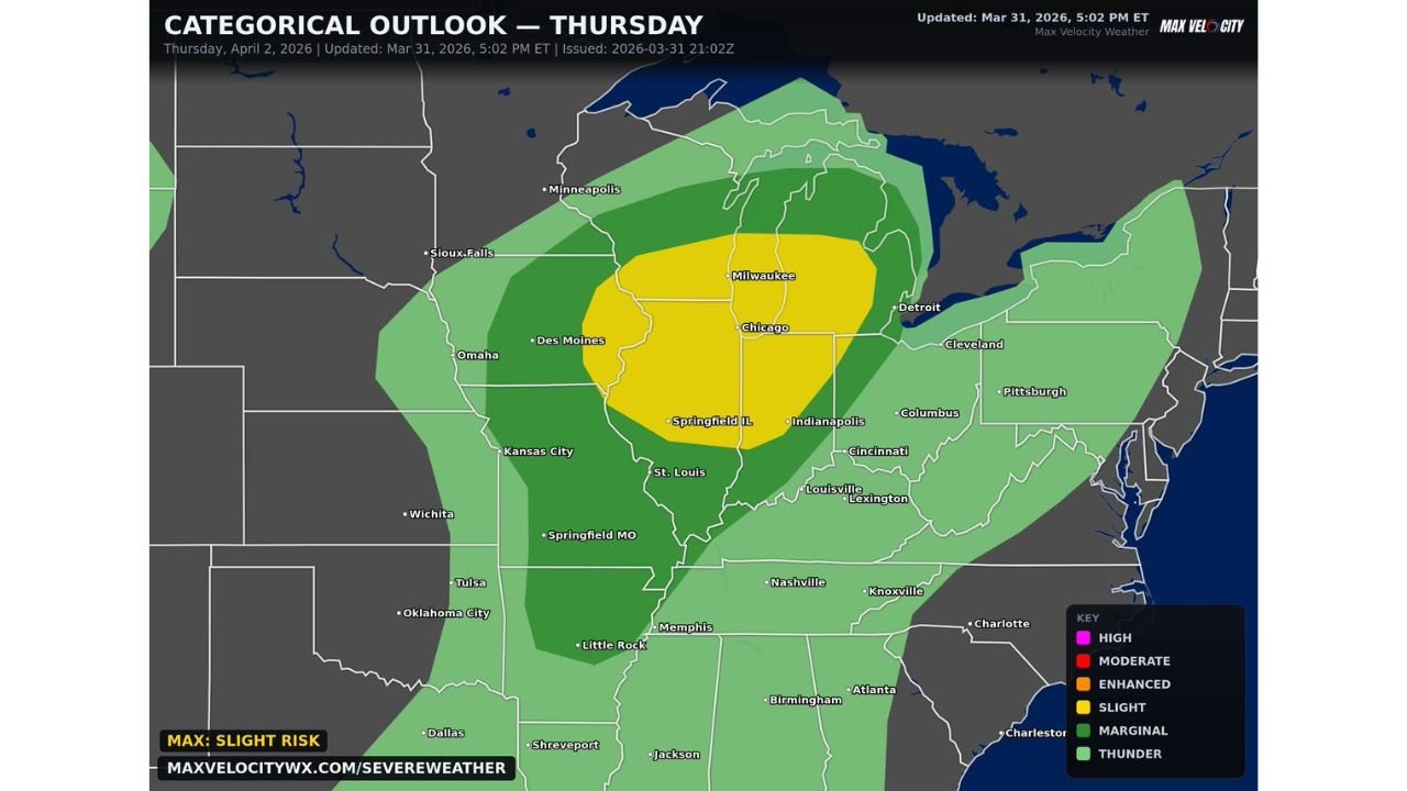
What the Categorical Outlook Is Showing
The Categorical Outlook for Thursday April 2, 2026, updated at 5:02 PM ET on March 31, shows a clear and well-defined risk structure across the Midwest.
The yellow Slight Risk zone — the highest-confidence severe weather area on this map — covers a broad swath running from Des Moines and Iowa City eastward through Chicago, Milwaukee, Springfield IL and Indianapolis. This yellow zone represents the area where organized severe weather is most expected on Thursday and where the tornado, hail and wind threats are all elevated above background levels.
Surrounding the yellow core is a darker green Marginal Risk zone extending outward in all directions — reaching Minneapolis and Sioux Falls to the northwest, Kansas City and St. Louis to the southwest, Detroit and Cleveland to the east and Louisville and Nashville to the southeast. This broader zone faces a lower but real severe weather threat if storms expand beyond the core yellow area.
The outermost lighter green Thunderstorm zone covers an even wider footprint from the northern Plains through the Deep South — indicating that while organized severe weather is less likely at the margins, general storm activity is expected across this large geographic area Thursday.
Iowa and Missouri: Where Supercells Would Initiate
The forecast is specific about where the most dangerous storms would first develop if Thursday’s atmosphere cooperates. Iowa and Missouri are the initiation zone — the states where discrete supercell thunderstorms would fire first along the dryline and frontal boundary during the early-to-mid afternoon hours.
Des Moines, Iowa City, Cedar Rapids and Kansas City sit in the zone where storm initiation is most likely on Thursday afternoon. Supercells that develop in this corridor would have access to the richest instability and the strongest wind shear of any location in the entire risk area — the combination that produces the most organized and long-lived tornado-capable storms.
As those storms mature and track eastward through the afternoon, they carry their tornado and hail potential into Illinois, Indiana and eventually the Great Lakes corridor by late afternoon and evening. The eastward storm motion means cities like Chicago, Springfield, Indianapolis and Fort Wayne face their peak severe weather threat roughly 2 to 4 hours after the initial Iowa and Missouri initiation.
Thursday Severe Weather Outlook Table
| Zone | Key Cities | Risk Level | Tornado Potential | Timing |
|---|---|---|---|---|
| Slight Risk — Yellow | Chicago, Milwaukee, Des Moines, Indianapolis | 🟡 Slight | 🔴 Strong tornadoes possible if atmosphere clears | Afternoon into evening |
| Marginal Risk — Green | Kansas City, St. Louis, Detroit, Cleveland | 🟢 Marginal | 🟠 A few tornadoes possible | Afternoon into evening |
| Thunder Zone | Minneapolis, Nashville, Memphis | ⛈️ Thunder | 🟡 Isolated possible | Variable |
| Key Variable | Early convection clearing | Critical | Determines storm mode | Morning hours |
State-by-State Impact for Thursday
🔴 Iowa — Des Moines, Cedar Rapids, Iowa City, Davenport — The supercell initiation zone for Thursday. If the morning atmosphere clears, Iowa faces the highest tornado potential of any state in the risk corridor. The I-80 corridor across Iowa is the primary track for afternoon supercell development. Strong tornadoes are explicitly on the table for Iowa if Thursday’s setup fully materializes.
🔴 Illinois — Chicago, Rockford, Springfield, Peoria — The yellow Slight Risk zone covers the entire northern half of Illinois including the Chicago metro. Supercells tracking east out of Iowa and Missouri will reach northern Illinois during the mid-to-late afternoon hours. Chicago and the surrounding suburbs face a genuine strong tornado threat if discrete supercells maintain their organization while crossing the state line. The I-90 and I-88 corridors are in the direct storm path.
🔴 Indiana — Indianapolis, Fort Wayne, South Bend — Inside the yellow Slight Risk zone. Storms arriving from Illinois will reach Indianapolis and the I-65 corridor during the late afternoon and early evening hours. Large hail and damaging winds are the highest-confidence threats for Indiana, with tornado potential depending on storm mode at the time of arrival.
🟠 Missouri — Kansas City, St. Louis, Columbia — On the southwestern edge of the yellow zone and inside the broader green Marginal Risk. Missouri sits in the storm initiation zone alongside Iowa — Kansas City faces afternoon supercell development directly, while St. Louis is in the path of eastward-tracking storms through the evening hours.
🟠 Michigan — Detroit, Kalamazoo, Grand Rapids — On the eastern edge of the yellow Slight Risk zone. Detroit and the Metro Detroit area face severe weather potential as storms track northeast out of Indiana and Illinois during Thursday evening. Damaging winds and large hail are the primary threats as storm mode may be evolving toward linear by the time systems reach Michigan.
🟠 Wisconsin — Milwaukee, Madison, Green Bay — Milwaukee sits inside the yellow Slight Risk zone — one of the northernmost cities in the core risk area. Thursday afternoon and evening carries a genuine severe weather threat for Milwaukee and the lakefront communities.
🟢 Minnesota — Minneapolis, Sioux Falls — Inside the green Marginal Risk zone. Severe weather is possible at the northern fringe of the outbreak if storms expand further north than currently modeled.
🟢 Kentucky and Tennessee — Louisville, Lexington, Nashville — Southern edge of the green zone. Severe weather possible Thursday evening as any organized storm activity tracks southeast, but confidence for this region is lower than for the core Midwest states.
What You Need to Do Before Thursday Morning
Tonight is the preparation window. By Thursday morning, the outcome of the early convection question will start becoming clear — but your preparation should be complete before you go to sleep tonight, not after you check the morning forecast.
If you live in Chicago, Des Moines, Indianapolis or Milwaukee — review your severe weather shelter plan right now. Know exactly where you go in your building if a tornado warning is issued. In a high-rise apartment or office building, interior stairwells on lower floors are your best option. In a house, the lowest floor interior room away from windows.
Wireless emergency alerts must be active on every phone. Thursday’s storm initiation in Iowa and Missouri during the afternoon means that by the time storms reach Chicago or Indianapolis, there may be limited warning time if storm motion is fast. Active alerts are non-negotiable for Thursday.
Check the morning forecast update. The single most important data point on Thursday morning will be whether the early cloud cover and storm activity from overnight is clearing or persisting. That answer will significantly change the threat level for the afternoon — and you should check for an updated outlook before leaving for work Thursday morning.
Thursday April 2 Could Be the Most Significant Severe Weather Day of the Week for the Midwest and Millions of Residents Are Inside the Threat Zone
The setup is real, the potential is elevated and the time to prepare is tonight. Stay informed at ChicagoMusicGuide.com — your source for Thursday severe weather updates, tornado probability tracking and outbreak coverage across Iowa, Illinois, Indiana, Missouri and the entire United States.