
Iowa, Missouri and Illinois Face a Growing Severe Weather Threat Thursday April 2 as Model Data Highlights an Active Storm Corridor From Des Moines Through Chicago and Into St. Louis
DES MOINES, IA — Thursday April 2nd is quietly emerging as a severe weather day to watch across the Midwest — and the latest high-resolution model data is now specific enough to draw a clear picture of where the greatest storm potential exists. Iowa, Missouri and Illinois are the three states most directly in the crosshairs for Thursday’s setup, with the model simulation showing an active and organized storm corridor stretching from Des Moines and Cedar Rapids southward through Galesburg, Quincy and into the St. Louis metro area. No official SPC risk area has been outlined yet — but one is expected to be issued tonight — and the atmospheric signal supporting isolated to scattered severe storms across this corridor is real enough to take seriously right now.
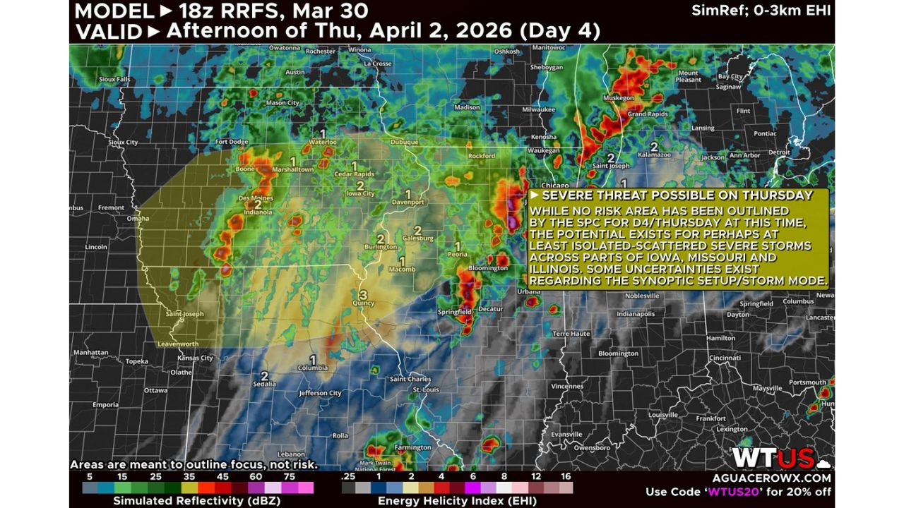
What the Model Is Showing for Thursday Afternoon
The RRFS high-resolution model, run at 18z March 30, valid for the afternoon of Thursday April 2 shows two pieces of data that together tell the Thursday story very clearly.
The simulated radar reflectivity — the green, yellow and red colors on the left side of the map scale — shows organized storm cells and clusters developing across a corridor stretching from northeastern Iowa through central Illinois and into the St. Louis region. The most intense simulated storm activity on this model frame is concentrated near Quincy, Galesburg, Burlington and the Iowa City to Davenport corridor — exactly the zone where the atmospheric ingredients are coming together most favorably on Thursday.
The Energy Helicity Index — the EHI values plotted on the map — is the second critical piece of data. EHI is a combined measure of two key severe weather ingredients: instability and wind shear. Instability is the fuel — the atmospheric energy available for storms to tap. Wind shear is the rotation mechanism — the change in wind speed and direction with altitude that organizes storms into supercells and keeps them rotating long enough to become dangerous.
EHI values of 1 or higher are generally associated with supercell and tornado potential. The Thursday model is showing EHI values of 1 across Iowa and northern Illinois, values of 2 across central Illinois and the Burlington to Quincy corridor, and a localized value of 3 near the Quincy area — the highest reading on the entire map and a signal that warrants specific attention for that part of west-central Illinois and the Missouri border region.
What EHI Values Actually Mean for Residents
For anyone who is not a meteorologist, here is a straightforward breakdown of what those EHI numbers mean for Thursday’s storm threat:
EHI of 1 — Supercell thunderstorms are possible. Tornadoes can occur but are not guaranteed. This is the baseline severe weather concern level.
EHI of 2 — Supercell potential increases. Significant tornadoes become more likely with any storm that develops in this environment. This is the level that gets forecasters paying close attention to a setup.
EHI of 3 — The highest value on Thursday’s map. At EHI of 3, the environment is supportive of strong, long-track tornadoes if supercell storms can develop and sustain themselves. This value near Quincy, Illinois and the western Illinois-Missouri border is the single most significant data point on the entire Thursday model frame.
What Is Still Unknown — And Why Confidence Is Low
Here is where the honest uncertainty of this forecast needs to be stated clearly. It is too early to know the exact storm timing, storm mode or specific hazards for Thursday’s event with high confidence. Two key uncertainties are driving the low confidence at this range.
The first uncertainty is storm mode — whether Thursday’s storms develop as discrete supercells or quickly organize into a squall line. Discrete supercells in an EHI 2-3 environment are capable of producing significant tornadoes. A squall line in the same environment is more likely to produce widespread damaging winds. The outcome is dramatically different depending on which mode dominates — and that detail will not be clear until Thursday morning at the earliest.
The second uncertainty is synoptic setup — the exact positioning and timing of the upper-level shortwave and surface boundaries that trigger storm development. A shortwave that arrives slightly early, slightly late or slightly north or south of the current model solution can shift the entire risk corridor by 50 to 150 miles in any direction.
An SPC Day 3 risk area is expected to be outlined tonight — and that will be the first official acknowledgment that Thursday’s severe weather potential has crossed the threshold of forecast confidence required for a categorical risk designation.
Thursday Severe Weather Outlook Table
| Zone | EHI Values | Storm Potential | Primary Threats | Confidence |
|---|---|---|---|---|
| NE Iowa — Cedar Rapids, Dubuque | EHI 1-2 | Isolated severe | Wind, hail, tornado possible | 🟡 Low-Moderate |
| Central Illinois — Galesburg, Peoria | EHI 1-2 | Isolated to scattered severe | Damaging winds, hail | 🟡 Low-Moderate |
| W. Illinois — Quincy, Burlington | EHI 2-3 | Scattered severe, supercell possible | Tornado, large hail, wind | 🟠 Moderate |
| Missouri — St. Louis, Columbia | EHI 1-2 | Isolated severe possible | Damaging winds, hail | 🟡 Low |
| Chicago Metro | EHI 1 | Marginal severe possible | Wind, isolated hail | 🟡 Low |
| SPC Official Risk | Expected tonight D3 | Iowa, MO, IL focus | TBD | Pending |
Where Each State Stands for Thursday
🟠 Illinois — Quincy, Galesburg, Burlington, Peoria — The EHI 3 reading near Quincy and EHI 2 values across western and central Illinois make this the highest-priority zone on the entire Thursday map. If discrete supercells can develop in this corridor Thursday afternoon, the environment is capable of supporting significant tornado activity. The Quincy to Peoria corridor deserves the closest monitoring as Thursday approaches.
🟠 Iowa — Des Moines, Iowa City, Cedar Rapids, Davenport — EHI values of 1 to 2 across central and eastern Iowa with organized storm activity shown on the model simulation. The I-80 corridor across Iowa sits inside the elevated severe weather zone for Thursday afternoon.
🟠 Missouri — St. Louis, Columbia, Kansas City eastern suburbs — The southern extension of Thursday’s risk area reaches into Missouri. St. Louis and the surrounding metro face isolated severe weather potential Thursday afternoon and evening as the storm corridor tracks southeast.
🟡 Wisconsin and Michigan — Milwaukee, Kalamazoo — On the far northeastern fringe of the modeled storm activity. EHI values are lower here but some storm potential exists if the system extends further northeast than the current model solution shows.
🟡 Indiana — Eastern edge of the risk corridor. Indianapolis and the surrounding area may see the tail end of Thursday’s storm activity as systems track east through the afternoon.
What to Watch Between Now and Thursday Morning
Two things will significantly sharpen the Thursday forecast between now and the event itself.
First — the SPC Day 3 outlook expected tonight will provide the first official categorical risk designation for Thursday. Whatever risk level the SPC assigns — Marginal, Slight or higher — will set the baseline for how seriously the meteorological community is treating this setup. A Slight Risk or higher would be a meaningful signal given the current low-confidence context.
Second — Thursday morning model runs will be the most critical data for pinpointing exact storm timing, mode and placement. By Thursday morning, the high-resolution models will have dramatically better data to work with and the forecast uncertainty will narrow considerably. If you are in Iowa, Illinois or Missouri — Thursday morning is when you need to recheck the forecast before making any plans for the afternoon and evening.
Thursday Is the Middle Chapter of a Three-Day Severe Weather Story Across the Midwest and Central Plains
Wednesday night, Thursday and Friday are all carrying severe weather potential — and each day’s details are still being finalized. Stay informed at ChicagoMusicGuide.com — your source for daily severe weather updates, EHI and storm mode analysis across Iowa, Missouri, Illinois and the entire United States.