
January 30–February 1 Winter Storm Leaves 2–16 Inches of Snow Across North Carolina and South Carolina, With Melting Ongoing as of February 4
NORTH CAROLINA & SOUTH CAROLINA — As of Tuesday, February 4, updated snowfall analysis from the January 30 through February 1 winter storm shows widespread snow accumulation across both North Carolina and South Carolina, with totals ranging from under 1 inch along parts of the coast to more than 16 inches in the Piedmont and foothills. While melting has increased over the past two days, snow cover and lingering slick spots remain an issue in several inland areas, especially where the highest totals were recorded.
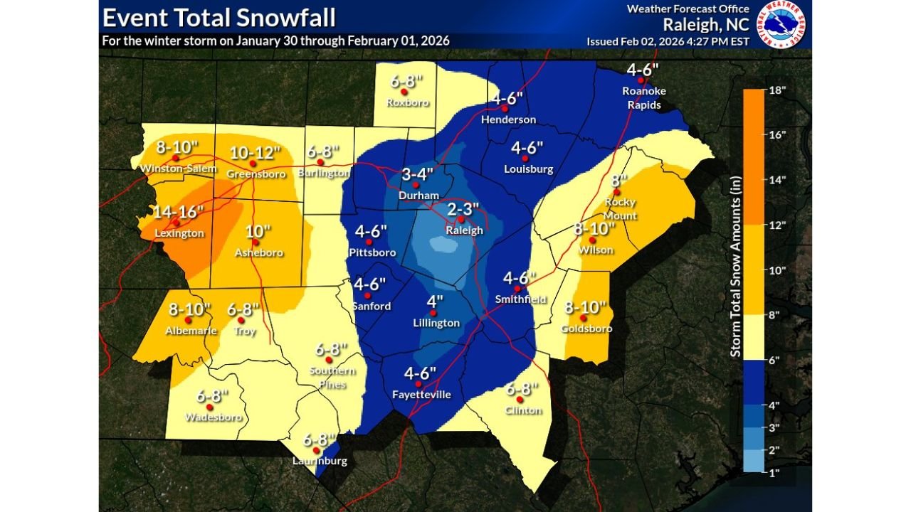
The snowfall data reflects compiled event-total reports from across both states following the conclusion of the storm.
North Carolina Recorded the Heaviest Snowfall of the Event
North Carolina saw the highest snowfall totals overall, particularly across the western Piedmont and central portions of the state.
- Lexington reported the storm’s highest totals, with 14 to 16 inches of snow.
- Greensboro received 10 to 12 inches, while Winston-Salem measured 8 to 10 inches.
- Asheboro recorded close to 10 inches, placing it among the hardest-hit communities.
Central North Carolina totals dropped sharply eastward:
- Durham reported 3 to 4 inches
- Raleigh measured 2 to 3 inches, one of the lowest totals in the central region
- Pittsboro, Sanford, Smithfield, and Fayetteville generally saw 4 to 6 inches
- Lillington measured around 4 inches
Eastern North Carolina still experienced significant snowfall:
- Wilson and Goldsboro both recorded 8 to 10 inches
- Rocky Mount measured about 8 inches
- Clinton reported 6 to 8 inches
- Roanoke Rapids and Louisburg were in the 4 to 6 inch range
As of February 4, melting has increased across much of the state, but snowpack remains visible in shaded areas and rural locations, particularly where totals exceeded 8 inches.
South Carolina Saw Widespread Snow, With Heaviest Totals in the Upstate
South Carolina experienced statewide snowfall, with the highest totals concentrated across the Upstate and northern Midlands.
- Greenville, Spartanburg, and Gaffney reported 7 to 8 inches
- Rock Hill measured around 7 inches
- Lancaster saw 5 to 6 inches
- Union recorded approximately 6 to 7 inches
Midlands snowfall was more moderate:
- Columbia reported 2 to 3 inches
- Newberry, Irmo, and Camden generally measured 3 to 4 inches
- Sumter recorded 2 to 3 inches
Southern and coastal areas saw lighter accumulation:
- Charleston measured around 0.5 inches
- Summerville and Hanahan were near 1 inch
- Beaufort stayed under 1 inch
- Hilton Head Island recorded roughly 2 to 3 inches
By February 4, melting is ongoing statewide, but patchy snow and refreezing overnight continue to affect secondary roads, especially inland.
Melting Improving Conditions, but Hazards Persist on February 4
With daytime temperatures rising since the storm ended, snowmelt has accelerated across both Carolinas. Main roads have largely improved, but treacherous conditions persist in:
- Shaded areas
- Elevated surfaces
- Rural and less-traveled roads
- Overnight and early-morning hours when refreezing occurs
Areas that received double-digit snowfall totals are taking longer to fully clear, and residual snowpack remains visible in many inland communities.
A Major Southeast Winter Storm With Lasting Impacts
The January 30–February 1 winter storm stands out as a high-impact Southeast winter event, delivering double-digit snowfall to parts of North Carolina and widespread measurable snow across South Carolina, including coastal areas where snow is relatively rare.
Even as of February 4, the storm’s effects remain visible, highlighting how significant winter systems can be when cold air and moisture align across the region.
For continued winter weather coverage, post-storm analysis, and regional updates, stay with Chicagomusicguide.com.