
January Ice Storm’s Aftermath Raises New Threat as 50+ MPH Winds Target Weakened Trees Across Louisiana, Mississippi, Alabama and the Southeast
MONROE, LOUISIANA — Communities across the Deep South and Southeast are facing a renewed weather concern this weekend, not just because of strong wind potential, but because thousands of trees remain weakened from a significant January 23–26, 2026 ice storm. With forecasts calling for widespread wind gusts of 50+ mph, even lower gust speeds could trigger fresh damage in areas still recovering.
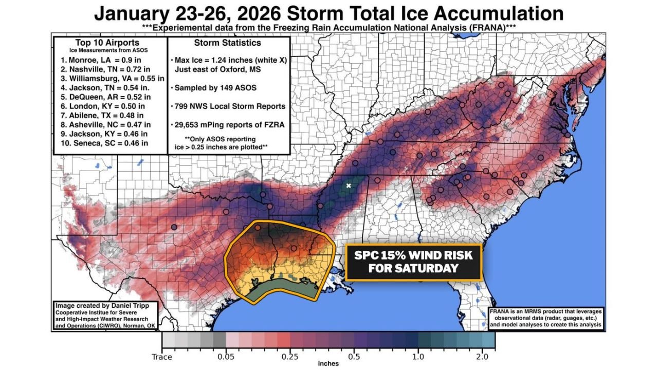
New analysis of storm total ice accumulation data shows just how widespread and intense the late-January event was — and why the northern edge of the upcoming wind risk zone must be closely monitored.
Ice Storm Left a Swath of Damage From Louisiana to the Carolinas
According to experimental Freezing Rain Accumulation National Analysis (FRANA) data, the January 23–26 storm produced a broad corridor of significant ice from Texas and Louisiana through Mississippi, Alabama, Tennessee, Kentucky, Virginia, and into the Carolinas.
The storm’s statistics reveal:
- Maximum ice accumulation: 1.24 inches, just east of Oxford, Mississippi
- 149 ASOS observation sites sampled
- 799 National Weather Service local storm reports
- Nearly 29,653 mPing reports of freezing rain
Airports reporting notable ice totals included:
- Monroe, Louisiana — 0.9 inches
- Nashville, Tennessee — 0.72 inches
- Williamsburg, Virginia — 0.55 inches
- Jackson, Tennessee — 0.54 inches
- DeQueen, Arkansas — 0.52 inches
- London, Kentucky — 0.50 inches
- Abilene, Texas — 0.48 inches
- Asheville, North Carolina — 0.47 inches
- Jackson, Kentucky — 0.46 inches
- Seneca, South Carolina — 0.46 inches
A continuous belt of 0.25 to 1.0+ inch ice totals stretched across portions of Mississippi, Alabama, Georgia, Tennessee, and the Carolinas, leaving trees coated and structurally compromised.
SPC 15% Wind Risk Targets Ice-Damaged Region
Now, attention turns to the Storm Prediction Center’s 15% wind risk area for Saturday, which overlaps directly with many of the hardest-hit ice zones — particularly across Louisiana, Mississippi, Alabama, and parts of Georgia.
This alignment raises concern among forecasters. Trees that endured heavy ice loading just weeks ago may already have hidden fractures, weakened root systems, and stressed limbs. Even without ice this time, strong gradient winds or convective gusts could bring down limbs more easily than normal.
Meteorologists note that 50+ mph wind gusts could cause tree damage, but in areas with prior ice stress, even gusts slightly below that threshold may be enough to trigger outages and debris issues.
The northern extent of the wind risk zone is especially critical. That boundary lines up closely with some of the heavier January ice totals across central Mississippi into northern Alabama and western Georgia.
Why Weakened Trees Matter More Than Wind Speeds Alone
During the January event, some communities saw ice accretions approaching or exceeding half an inch, which significantly increases branch weight. In some cases — such as near Oxford, Mississippi — totals exceeded one inch, a level often associated with widespread tree breakage.
Even if damaged trees did not immediately fall during the ice storm, internal structural weakness can persist for weeks. Saturated soil conditions following repeated winter systems also reduce tree stability.
This weekend’s setup could therefore produce localized tree damage disproportionate to the wind speeds observed, especially in neighborhoods where cleanup remains incomplete.
Power infrastructure may also be more vulnerable if lines are still surrounded by stressed limbs.
Communities Urged to Monitor Conditions Closely
Residents across Louisiana, Mississippi, Alabama, and Georgia should prepare for the possibility of scattered power outages and downed limbs, particularly in wooded or previously ice-affected areas.
Safety recommendations include:
- Securing loose outdoor items ahead of stronger winds
- Avoiding parking vehicles beneath large trees
- Charging devices in advance in case of outages
- Reporting downed power lines immediately
The situation highlights how winter weather impacts can compound over time. While the January ice storm delivered the initial blow, this weekend’s wind event could expose lingering vulnerabilities.
As the Southeast enters another active stretch of weather, awareness of prior storm damage may prove just as important as tracking the next forecast model run.
For continued updates on severe weather risks, winter storm impacts, and regional forecasts across the South and Mid-Atlantic, visit ChicagoMusicGuide.com for the latest weather coverage.