
Kansas and Oklahoma Identified as Spring Tornado Hotspot as ENSO Transition Years Show Persistent Plains Focus
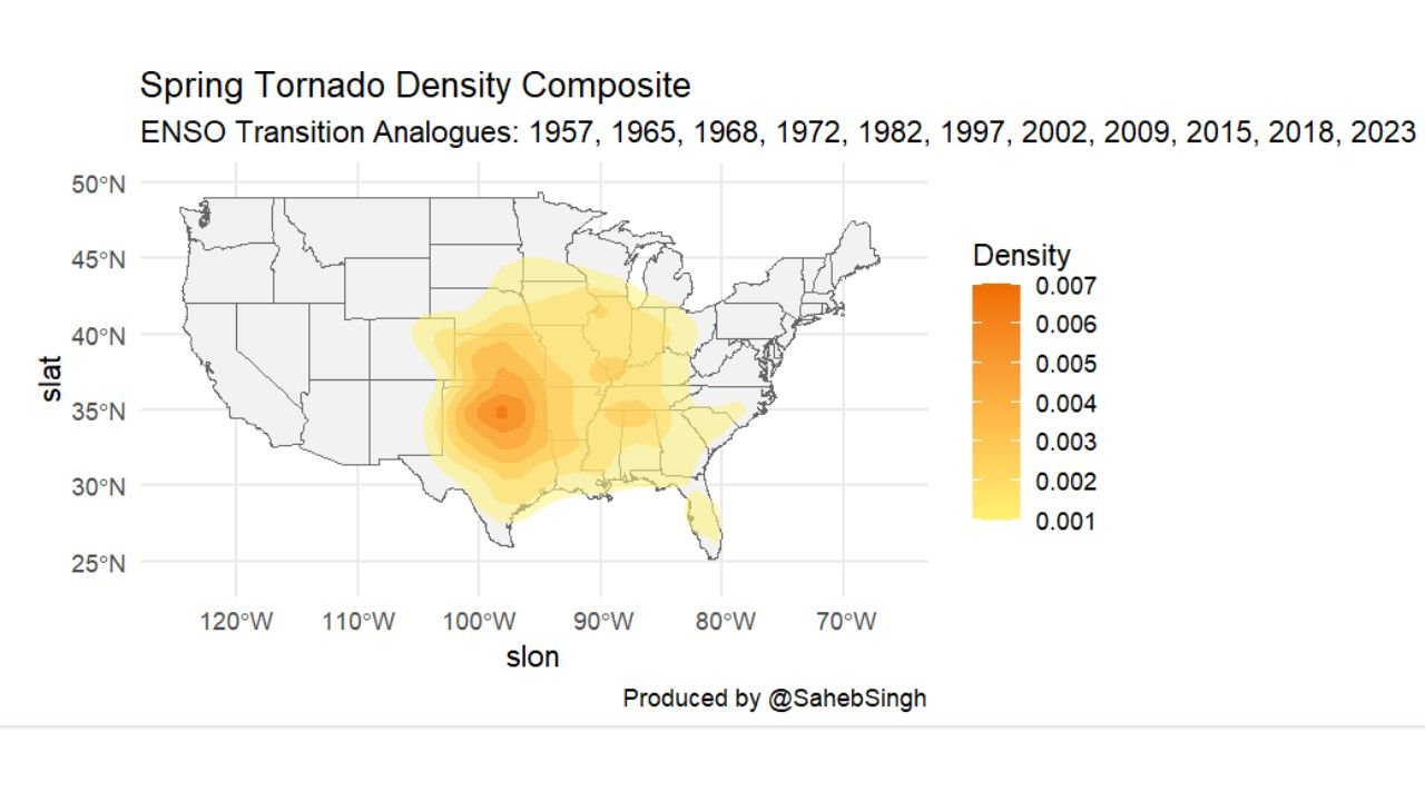
KANSAS — A new spring tornado density composite built from multiple ENSO transition years is placing Kansas and Oklahoma directly in the center of the highest tornado concentration zone, with density signals extending east into Missouri, Arkansas, and Alabama. The data, which analyzes historical analog years including 1957, 1965, 1968, 1972, 1982, 1997, 2002, 2009, 2015, 2018, and 2023, shows a persistent Plains-focused pattern during similar climate transitions.
The strongest density core is centered across central and southern Kansas into northern Oklahoma, highlighting the traditional heart of “Tornado Alley” as the most consistent spring hotspot in these transition setups.
Plains Core Shows Strongest Tornado Density Signal
The composite density map reveals the highest concentration shading across:
- Central Kansas
- Southern Kansas
- Northern and Central Oklahoma
This corridor aligns closely with historical severe weather outbreaks during past ENSO transition springs. The density gradient gradually weakens but remains elevated into:
- Missouri
- Arkansas
- North Texas
- Western Tennessee
- Northern Alabama
The clustering near the Kansas-Oklahoma border suggests that during these transition years, the atmospheric setup frequently favors classic dryline and frontal boundary interactions across the central Plains.
Missouri and Alabama Also Show Sustained Density
Beyond the Plains core, the data highlights a secondary density axis stretching from Missouri through Arkansas and into northern Alabama. This alignment closely matches historical Storm Prediction Center (SPC) outbreak corridors during active spring seasons.
Missouri sits along the eastern edge of the primary Plains focus, often acting as a transition zone where Plains supercells track northeast into the Midwest. Meanwhile, northern Alabama appears within a zone of consistent secondary density — reflecting the vulnerability of the Deep South during early and mid-spring severe weather seasons.
While March activity can vary depending on the specific year, the Plains core remains persistent in the analog set.
ENSO Transition Years and Big Outbreak Patterns
The analog list includes several years known for significant tornado activity. ENSO transition springs — particularly shifts between El Niño and La Niña phases — often enhance:
- Stronger jet stream dynamics
- Increased wind shear across the Plains
- Frequent Gulf moisture return
- Repeated severe weather setups
Although March variability exists, the composite indicates that when major outbreak seasons occur in these analog years, they frequently center over Kansas and Oklahoma first, before expanding eastward.
This reinforces the idea that early spring severe weather tends to initiate in the Plains before gradually shifting into the Mississippi Valley and Southeast as the season progresses.
What This Means for the Central and Southern U.S.
The strongest takeaway from the density composite is the consistency of the Plains focus. Even when seasonal averages fluctuate, the central corridor from Kansas through Oklahoma into north Texas remains the most reliable region for concentrated tornado activity during ENSO transition years.
For residents in:
- Wichita, Kansas
- Topeka, Kansas
- Oklahoma City, Oklahoma
- Tulsa, Oklahoma
- Joplin, Missouri
- Little Rock, Arkansas
- Huntsville, Alabama
Spring preparedness becomes especially critical when large-scale climate transitions align with seasonal warming.
Pattern Suggests Plains Still Central to Spring Risk
While March activity may vary from year to year, the broader composite reinforces a longstanding meteorological truth: the central Plains remain the backbone of U.S. spring tornado activity.
As temperatures rise and Gulf moisture surges northward in coming weeks, the historical analog data suggests that Kansas and Oklahoma should remain under close watch. The extension of density into Missouri and Alabama also highlights the importance of vigilance across the broader central and southeastern United States.
Spring transition periods often bring rapid shifts in severe weather potential, and composite data like this provides valuable context for understanding where the most persistent risk zones historically reside.
As the 2026 spring season approaches, residents across the Plains and Deep South should remain attentive to updated outlooks and preparedness messaging. For continued updates on severe weather patterns, spring storm trends, and regional weather developments, visit ChicagoMusicGuide.com.