
Kansas City to Tulsa in Enhanced Risk as Severe Storms Friday Could Bring Tornadoes, Golf Ball Hail and Damaging Winds — Chicago and Springfield Also in Broader Threat Zone
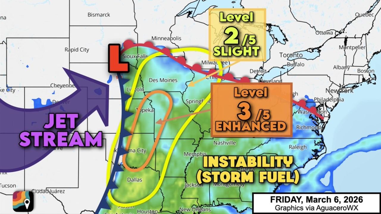
UNITED STATES — Friday, March 6 is trending toward a potentially impactful severe weather day across the Plains and Mississippi Valley, with the Storm Prediction Center outlining an Enhanced Risk (Level 3 out of 5) from Kansas City and St. Joseph, Missouri south through Tulsa, Oklahoma City and Ardmore, Oklahoma.
The developing setup also places Chicago, Springfield, Illinois, La Crosse, Wisconsin and parts of western Illinois inside a broader Slight Risk (Level 2 out of 5) area that stretches all the way southwest to Dallas, Waco and Abilene, Texas.
Enhanced Risk: Kansas City to Tulsa Corridor
The most concerning zone includes:
- Kansas City, Missouri
- St. Joseph, Missouri
- Tulsa, Oklahoma
- Oklahoma City, Oklahoma
- Ardmore, Oklahoma
Within this corridor, forecasters indicate:
- A few supercells capable of tornadoes
- Damaging straight-line wind gusts
- Large hail, possibly up to golf ball size
Early in the event, storms may remain discrete — meaning individual rotating supercells are possible before any larger storm lines form.
Slight Risk Extends to Chicago and Western Illinois
The broader Level 2 risk zone spans a wide swath of the central U.S., including:
- Chicago, Illinois
- Springfield, Illinois
- La Crosse, Wisconsin
- Springfield, Missouri
- Wichita, Kansas
- Omaha and Lincoln, Nebraska
- Dallas, Waco and Abilene, Texas
While the highest tornado potential sits southwest of Illinois, parts of the Midwest — including western and central Illinois — remain in the zone where scattered severe storms could track northeast later Friday into the evening.
For Chicago-area readers, this means monitoring storms developing to the southwest that could organize and move toward the region as the system evolves.
The Setup: Jet Stream Over a Moist “Warm Sector”
A powerful jet stream is forecast to sweep over an expansive warm sector that will be dragged northward by low pressure near Sioux Falls, South Dakota.
Key ingredients in play include:
- Warm, humid Gulf air surging north
- Increasing atmospheric instability (“storm fuel”)
- Strong wind shear — changing winds with height
As a cold front presses eastward into that unstable air mass, thunderstorms are expected to blossom across the Plains and then track northeast into the Mississippi Valley.
Why Tornadoes Are Possible
The combination of:
- Strong upper-level winds
- A strengthening low-level jet stream after sunset
- Increasing instability through the afternoon
creates an environment supportive of rotating storms. Any supercell that remains isolated could produce:
- A tornado
- Large hail
- Intense localized wind damage
However, forecasters note that one potential limiting factor is storm interaction — if storms merge too quickly into messy clusters, tornado potential could become more localized.
Evening and Overnight Concerns
Scattered strong to severe thunderstorms are likely to carry into the night as a strengthening low-level jet acts like a conveyor belt of warm, humid air about a mile above the ground.
This nighttime component increases concern for:
- After-dark warnings
- Rapid storm intensification
- Expanding wind damage potential
Communities from Oklahoma and Kansas into Missouri and Illinois should have multiple ways to receive weather alerts Friday evening.
Bottom Line
Friday’s setup supports an Enhanced Risk of severe weather from Kansas City to Tulsa, with tornadoes, damaging winds and golf ball-size hail possible.
Meanwhile, a broader Slight Risk extends north and east into Chicago, Springfield, Wisconsin and western Illinois, meaning storms developing in the Plains could influence parts of the Midwest later in the day.
ChicagoMusicGuide.com will continue to monitor forecast updates as this potentially significant early-season severe weather event approaches.