
Late March Forecast Raises Concern as Supercell Storm Signals Surge Across Texas, Louisiana, Mississippi, Alabama, Arkansas and the Gulf Coast
DALLAS, TEXAS — Long-range weather models are beginning to highlight a notable signal for increased supercell thunderstorm potential across the southern United States during late March, raising concerns among meteorologists as the spring severe weather season approaches.
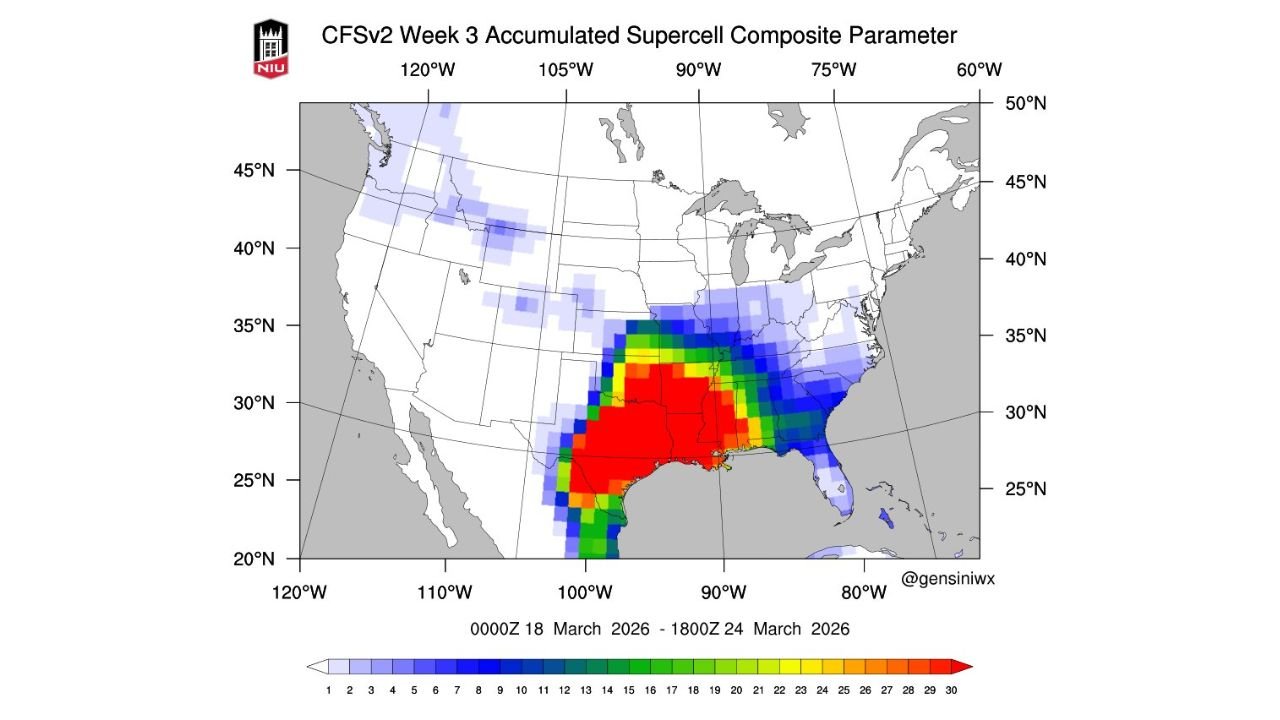
The CFSv2 Week 3 Accumulated Supercell Composite Parameter forecast, covering the period from March 18 through March 24, 2026, shows a strong concentration of severe weather potential stretching from Texas across Louisiana, Arkansas, Mississippi and Alabama, with elevated signals also extending toward Georgia and parts of the Southeast.
Forecasters emphasize that this outlook is still several weeks away, but the strong signal appearing across multiple southern states suggests conditions may favor frequent severe thunderstorms capable of producing supercells.
Highest Supercell Signal Centered Over Texas and Louisiana
According to the model projection, the strongest signal for supercell-supportive conditions appears across Texas, Louisiana and southern Arkansas, where the forecast map shows the most intense values on the supercell composite parameter scale.
This region includes major cities such as:
- Dallas and Fort Worth, Texas
- Houston, Texas
- Austin and San Antonio, Texas
- Shreveport, Louisiana
- Little Rock, Arkansas
Meteorologists say areas highlighted in deep red and orange on the forecast map represent locations where atmospheric ingredients favorable for supercells may occur more frequently during the forecast period.
Supercell thunderstorms are among the most dangerous storm types, often producing large hail, damaging winds and tornadoes.
Severe Weather Corridor Extends Across the Gulf States
Beyond Texas and Louisiana, the model also shows a broad area of increased severe weather potential extending across:
- Mississippi
- Alabama
- Georgia
- Parts of the Florida Panhandle
These regions appear in moderate to elevated supercell parameter values, indicating conditions that could support organized thunderstorms capable of producing severe weather.
Meteorologists say this pattern is consistent with typical early spring severe weather corridors, which often form across the Gulf Coast states and Deep South as warm Gulf moisture interacts with strong upper-level systems moving across the country.
Secondary Signal Extends Into the Lower Mississippi Valley
A secondary region of elevated supercell potential appears across the lower Mississippi Valley, including portions of Arkansas, Tennessee and western Mississippi.
While the signal is somewhat weaker compared with the Gulf Coast region, the model still indicates periodic opportunities for strong thunderstorms during the late-March timeframe.
Cities within this zone include:
- Memphis, Tennessee
- Jackson, Mississippi
- Little Rock, Arkansas
Meteorologists note that this corridor often acts as a transition zone where severe weather systems move from the Plains toward the Southeast.
Midwest and Northern Plains Show Lower Supercell Potential
Farther north, including areas across the Midwest and Great Lakes, the model signal is much weaker.
States such as:
- Illinois
- Indiana
- Wisconsin
- Michigan
show only low levels of supercell parameter values, suggesting fewer opportunities for organized severe thunderstorms during this specific forecast window.
However, meteorologists caution that long-range models should not be interpreted as exact forecasts, but rather as indicators of where the atmospheric pattern may favor severe weather development.
Forecast Highlights Possible Start to Active Spring Storm Season
The emergence of a strong signal in long-range guidance is attracting attention among meteorologists because late March often marks the beginning of the most active part of the U.S. severe weather season.
During this period, increasing warmth and moisture from the Gulf of Mexico interact with powerful jet stream systems moving across the country, creating the conditions needed for supercell thunderstorms and tornado outbreaks.
While it remains far too early to determine whether specific storms will develop, the current model guidance suggests the southern Plains and Gulf Coast states could experience a period of heightened severe weather potential later in the month.
Forecasters will continue monitoring temperature trends, moisture levels, and atmospheric instability patterns over the coming weeks to determine whether the severe weather signal strengthens or weakens.
As the spring season approaches, residents across Texas, Louisiana, Mississippi, Alabama and surrounding states are encouraged to stay informed about evolving weather patterns.
For continued updates on severe weather forecasts, major storm systems, and regional weather developments across the United States, visit ChicagoMusicGuide.com.