
Louisiana, Mississippi, Alabama, and Georgia Face Ongoing Flash Flood Threat as WPC Flags Highest Short-Term Risk
LOUISIANA — A continued flash flood threat is unfolding across parts of the Deep South, with the Weather Prediction Center (WPC) highlighting southeastern Louisiana, southern Mississippi, southern and central Alabama, and western to northern Georgia as areas of growing concern. New guidance shows repeated rounds of heavy rainfall capable of overwhelming drainage systems and triggering rapid flooding, especially in low-lying and urban areas.
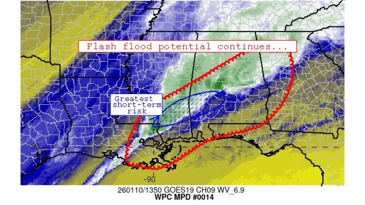
Why Flash Flood Risk Remains Elevated
Meteorologists point to a slow-moving storm system interacting with deep Gulf moisture, creating an environment favorable for persistent, heavy rain. The WPC’s Mesoscale Precipitation Discussion identifies the greatest short-term risk stretching from coastal Louisiana into southern Mississippi and Alabama, where rainfall rates may exceed what soils and waterways can handle.
This setup raises the risk of flash flooding, particularly where storms repeatedly track over the same locations. Areas that have already received rain are more vulnerable, as saturated ground reduces absorption and accelerates runoff into creeks, bayous, and city streets.
States and Regions Most at Risk
The current outlook focuses on a multi-state corridor:
- Louisiana: Southeastern parishes, including coastal zones and metro areas, face heightened risk due to poor drainage and proximity to tidal influences.
- Mississippi: Southern counties could see rapid water rises as bands of rain push eastward.
- Alabama: Southern and central sections are flagged for localized flash flooding, especially near rivers and urban centers.
- Georgia: Western and northern regions may experience runoff issues as rainfall spreads inland.
While not every community will see flooding, isolated to scattered flash flood incidents are possible anywhere storms stall or intensify.
Short-Term Impacts and What to Watch
Residents should be alert for water-covered roads, rapid creek rises, and temporary closures. Nighttime rainfall can be particularly dangerous, as flooding is harder to detect after dark. Emergency managers emphasize avoiding travel during heavy downpours and never driving through flooded roadways.
Forecast confidence is highest for short-term impacts, with the WPC stressing that conditions can change quickly if storm bands shift. Local advisories or Flash Flood Warnings may be issued on short notice.
How This System Could Evolve
Although the flash flood potential continues, forecasters note that the threat will gradually shift as the storm system progresses east. Communities outside the current risk zone should still monitor updates, as rainfall corridors can adjust with subtle changes in wind flow or storm speed.
Staying informed through official weather alerts and local emergency guidance is critical over the next 24–48 hours.
For ongoing weather updates, impact-focused forecasts, and regional coverage beyond the headlines, keep checking ChicagoMusicGuide.com for the latest developments and safety information.