
Major Early March Pattern Flip Brings Warm Surge to East, Heavy Rain for Texas to Tennessee, But Late-Month Cold Shots Still Loom
UNITED STATES — A significant atmospheric pattern change is taking shape for the first two weeks of March, signaling a transition away from deep winter cold across much of the country — at least temporarily.
However, forecasters caution against declaring winter completely over. While a thaw builds across the East next week, there are emerging hints that colder air could reappear later in March.
Jet Stream Realignment: Ridge East, Trough West
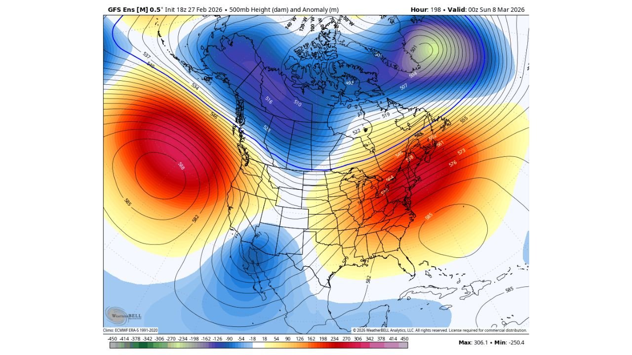
The latest ensemble mean pattern for around March 7–8 shows a dramatic realignment of the jet stream.
Key features include:
- A strong ridge building over the Eastern United States
- Persistent high pressure near the Florida coastline
- A trough positioned over the Desert Southwest
- Cold air bottled up across central and northern Canada
The ridge across the East supports:
- Above-normal temperatures from the Mid-Atlantic to New England
- A developing thaw in Boston, New York, Philadelphia, and Washington, D.C.
- Warmer conditions extending into parts of the Ohio Valley
Meanwhile, systems ejecting out of the Southwest will ride along the edge of the ridge, tracking into the Plains and Mississippi Valley.
Heavy Rain Targets Drought-Stricken States
The pattern strongly favors repeated storm systems developing from the Southwest and moving northeast across:
- Texas
- Arkansas
- Missouri
- Kentucky
- Tennessee
These are areas that have dealt with recent drought stress, and this setup could deliver much-needed rainfall.
Multiple waves tracking through this corridor increase the likelihood of:
- Widespread soaking rains
- Thunderstorms
- Potential flooding in localized areas
The combination of Gulf moisture and repeated disturbances makes this a rain-heavy pattern for the southern Plains and lower Mississippi Valley.
Chicago and the Midwest: Transition Zone
For Chicago and the Midwest, the pattern places the region near a battleground zone.
With a ridge dominating the East and troughing in the Southwest:
- Temperatures are likely to trend milder overall
- Precipitation chances increase
- Storm tracks will determine rain vs. late-season snow potential
While this setup leans warmer in the East, the Midwest could occasionally sit near the thermal gradient, meaning small track shifts could still allow for colder air intrusions.
New England Thaw Begins — For Now
The strengthening ridge supports a noticeable thaw in New England, where temperatures are expected to moderate as we move deeper into early March.
But forecasters emphasize this does not necessarily mean winter cold is finished.
Long-range hints suggest that:
- The jet stream may buckle again later in March
- Cold shots could return to the East
- Pattern volatility remains high
Desert Southwest Energy Keeps Pattern Active
The trough over the Desert Southwest plays a crucial role in keeping this pattern dynamic.
Each time energy ejects from:
- Arizona
- New Mexico
- Southern California
It can trigger storm development downstream across the Plains and Mississippi Valley.
This supports an active stretch rather than a single isolated storm.
Bottom Line: Warm Surge Now, But Winter Not Gone
Early March is bringing a major pattern flip:
- Warmer-than-average temperatures across the East
- A thaw in New England
- Repeated rain events from Texas through Tennessee and Kentucky
- Increased storm activity along the Plains-to-Ohio Valley corridor
However, signals still suggest winter may not be completely finished later in the month.
For now, the focus turns to an active, storm-driven pattern that delivers beneficial rain to drought-stricken states and milder air to the eastern U.S.
Stay with ChicagoMusicGuide.com for continued updates as this evolving March pattern unfolds.