
Major Warm-Up to Send Oklahoma and Central U.S. Soaring 25 to 35 Degrees Above Normal by Midweek
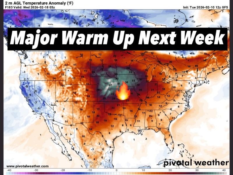
OKLAHOMA CITY, OKLAHOMA — After January’s Arctic punch, a dramatic pattern reversal is setting up across the middle of the country. Forecast temperature anomaly data valid Wednesday, February 18, 2026, shows a major warm-up expanding across the central United States, with temperatures projected to run 25 to 35 degrees above normal in some areas.
The most intense warmth appears centered over Oklahoma, placing the state squarely in the bullseye of this mid-February surge.
Oklahoma Sits in the Core of the Warmth
The anomaly map highlights deep red and purple shading across Oklahoma, Kansas, Nebraska, and portions of Missouri and Arkansas, indicating departures as high as 30 to 37 degrees above seasonal averages.
Cities throughout central Oklahoma could experience temperatures more typical of late March or early April, rather than mid-February. This level of warmth is not subtle — it represents a significant shift from recent cold conditions that dominated earlier in the season.
Surrounding states including Texas, Colorado, Iowa, and Illinois also show widespread positive anomalies, though the most extreme readings remain concentrated in the central Plains.
Midwest and Great Lakes Feel Spring-Like Conditions
The warming trend extends northeast into the Midwest and Great Lakes, including Illinois, Indiana, Michigan, Wisconsin, and Ohio. While anomaly values here appear slightly lower than in Oklahoma, many locations are still projected to run 15 to 25 degrees above normal.
For cities such as Chicago, Indianapolis, Detroit, and Milwaukee, this means a noticeable break from winter conditions. Snowpack could melt quickly where present, and daily highs may feel unusually mild for late February.
Even parts of the Mid-Atlantic and Northeast, including Pennsylvania and New York, show elevated temperatures compared to seasonal norms.
West Coast and Northern Tier Contrast
While much of the central and eastern United States warms significantly, portions of the West Coast, especially parts of California, show more neutral or slightly cooler readings in comparison. The most dramatic contrast, however, is between the central U.S. warmth and the colder anomalies lingering across far northern regions near the Canadian border.
The overall pattern suggests a strong upper-level ridge dominating the central U.S., allowing warm air to surge northward.
A Late-February Pattern Shift
This warming event is notable not just for its intensity but for its timing. Late February typically carries the risk of renewed Arctic outbreaks, yet current projections indicate that winter is unlikely to make a strong return in the immediate aftermath of this warm spell.
Forecast guidance suggests the warmth will build steadily through the early part of the week, peaking by midweek across the Plains and Midwest. The anomaly values underscore how unusual this shift is, particularly given the recent cold regime.
For residents across Oklahoma, Kansas, Missouri, Illinois, and surrounding states, next week may feel like someone flipped the seasonal switch overnight.
As the central United States prepares for a remarkable February warm-up, shifting weather patterns could impact travel, outdoor events, and early spring activities. For continued national weather updates and how changing conditions may affect concerts, festivals, and live events, visit ChicagoMusicGuide.com.