
Major Winter Storm to Bring Over a Foot of Snow, High Winds, and Widespread Travel Impacts Across the Plains, Midwest, and Great Lakes Into Sunday
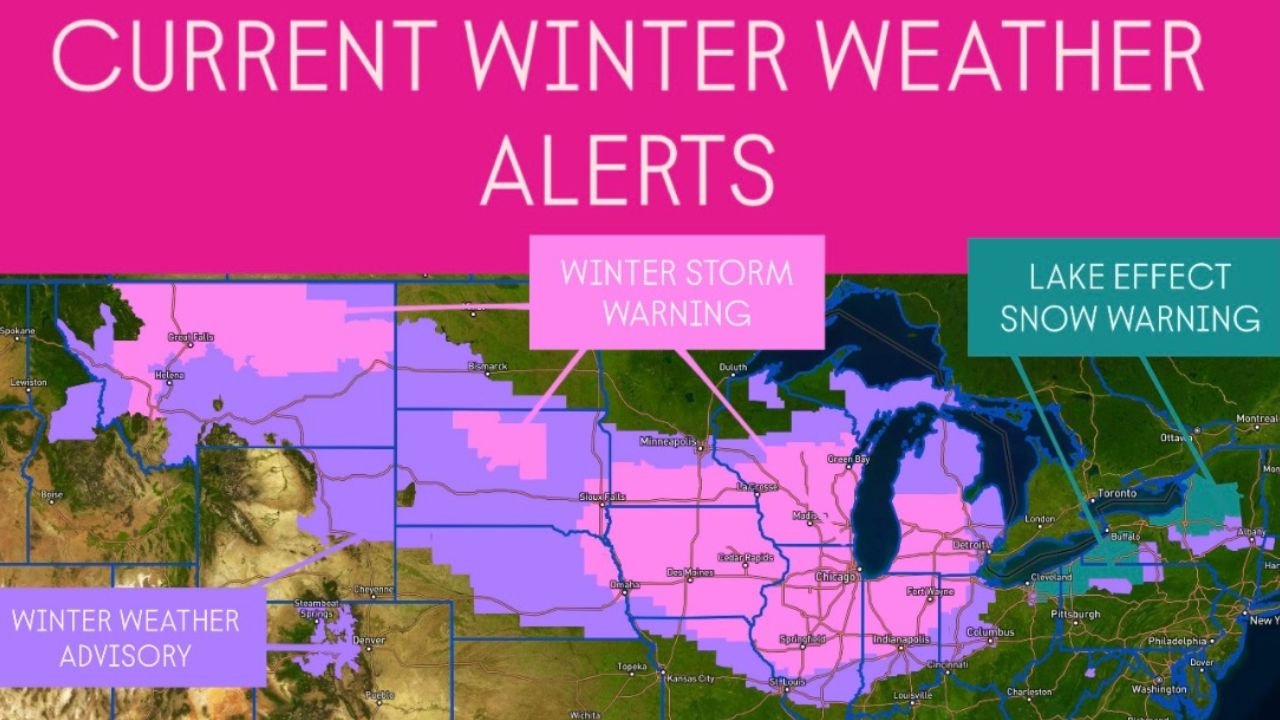
CHICAGO – Expanding Winter Storm Warnings as Powerful System Moves In From the Rockies, A major winter storm is rapidly developing across the northern U.S. Rockies and is expected to spread into the Plains and Midwest overnight into Saturday. Updated weather alerts now show a broad swath of Winter Storm Warnings, Winter Weather Advisories, and Lake Effect Snow Warnings stretching from Montana through the Dakotas, Nebraska, Iowa, Wisconsin, Illinois, Michigan, Indiana, and Ohio.
This system will intensify through the weekend, producing heavy snow, strong winds, and hazardous travel across many major metro areas.
Widespread Alerts Cover the Central U.S.
The latest alert map shows three major categories of winter hazards:
Winter Storm Warnings (Pink Areas)
These cover a significant portion of the central United States, including:
- Montana
- Wyoming
- North Dakota
- South Dakota
- Nebraska
- Minnesota
- Iowa
- Wisconsin
- Northern Illinois
- Michigan
- Northern Indiana
- Northern Ohio
This zone represents the highest confidence in heavy snow and strong winds, with widespread accumulation expected.
Lake Effect Snow Warnings (Teal Areas)
These primarily impact the Great Lakes snow belts, including:
- Western and northern Michigan
- Northwestern Pennsylvania
- Western New York
Localized lake-effect bands could push snow totals past a foot with visibility near zero at times.
Winter Weather Advisories (Light Purple Areas)
These regions will see lighter but still disruptive snow, along with blowing and drifting caused by ramping winds.
Over a Foot of Snow Possible in Heaviest Bands
Forecast models indicate that the storm will organize into long-lasting snow bands capable of producing more than 12 inches of accumulation in certain locations, especially across the Upper Midwest and Great Lakes.
Strong winds will accompany the snowfall, leading to:
- Sudden visibility drops
- Blowing and drifting snow
- Difficult road conditions
- Increased likelihood of travel delays for both air and ground transportation
For Chicago, accumulating snow and gusty winds are expected to contribute to a challenging Saturday into Sunday morning.
Important Considerations for Musicians, Performers, and Weekend Events
With the storm arriving during a busy weekend for concerts, rehearsals, holiday events, and late-night shows, performers across the Midwest should expect:
- Slower travel times between cities
- Potential delays affecting load-ins and sound checks
- Reduced attendance due to hazardous road conditions
- Possible venue schedule adjustments
- Safety concerns for early-morning or late-night travel
Artists traveling from Iowa, Wisconsin, Indiana, or Michigan into Chicago may encounter especially dangerous driving conditions overnight and into early Sunday.
A High-Impact Winter Weekend That Requires Caution
As the system crosses the region, its combination of heavy snowfall, strong winds, and lake-effect enhancement will create a challenging 48-hour period for transportation and regional movement. Staying updated with local forecasts will be essential for anyone on the road, especially performers and crews navigating tight schedules.
Are you changing your weekend music or travel plans because of this winter storm? Share your experience with us at ChicagoMusicGuide.com — we’re following this system closely and want to hear how it’s affecting you.