
Maryland Braces for Early-Morning Thunderstorms Friday as Strong Cold Front Approaches Baltimore Metro
MARYLAND — After a stretch of winter weather that included accumulating snow on Sunday and bitter cold on Monday and Tuesday, Maryland is now preparing for yet another rapid shift in conditions. Forecast models show that early-morning thunderstorms are likely on Friday, with some stronger “boomers” possible as a powerful cold front sweeps through the Baltimore Metro area.
This unusual December setup follows a week of dramatic weather swings across the state — and Friday’s event could bring heavy rain, lightning, gusty winds, and fast-moving storm lines before sunrise.
Strong Front Will Trigger Thunderstorms Across Central Maryland
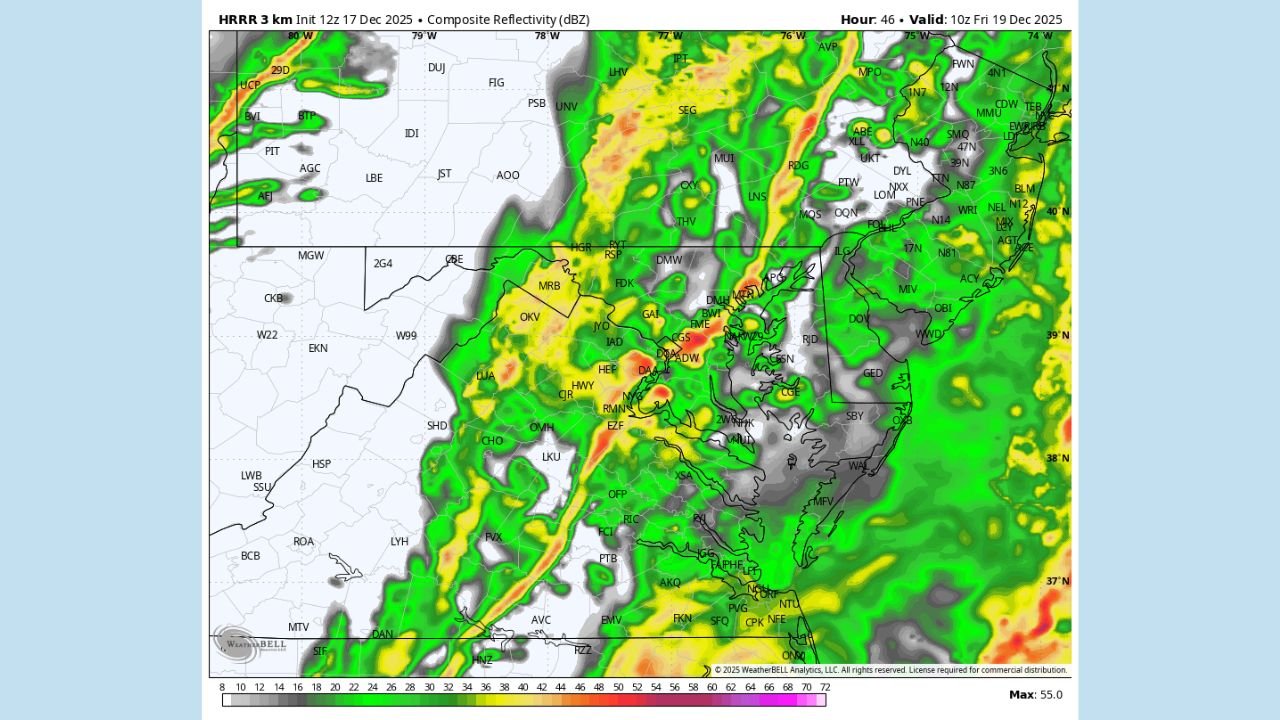
High-resolution model guidance indicates a well-defined line of storms forming to Maryland’s west overnight and sweeping eastward through the region after sunrise Friday.
- HRRR composite reflectivity maps show intense narrow bands of convection, especially across Washington, Frederick, Baltimore, Anne Arundel, Prince George’s, and Harford counties.
- Embedded heavier cells may produce brief downpours and isolated lightning.
The early timing — around 5–8 AM Friday — means much of the activity will occur during the morning commute, potentially reducing visibility and creating slick road conditions.
Lightning Possible as Instability Surges Ahead of the Front
Despite cold ground conditions left behind from earlier snowfall, the incoming air mass contains enough low-level moisture and dynamic lift to generate convective activity.
Model lightning density plots show:
- Bands of elevated lightning potential from southern Maryland through Baltimore and into northeastern Maryland
- Best chances between 7 AM and 10 AM, coinciding with the strongest frontal passage
- Signals for isolated thunder and brief electrical activity, uncommon for mid-December
These types of winter thunderstorms often occur when strong temperature contrasts collide with an advancing jet-powered front — exactly what Friday’s setup shows.
Heavy Rainfall and Rapid Temperature Swings
Before temperatures crash again behind the front Friday afternoon, the storm line may deliver:
- 0.25–0.75 inches of rain, locally heavier
- Wind gusts 30–40 mph along the line, especially in exposed areas
- Quick melt of leftover snow, contributing to slushy roads and poor drainage
Once the front clears, cold air will rush back in, setting up another stretch of frigid temperatures into the weekend.
An Unusual Weather Week for Maryland
This week has featured:
- Snow accumulation Sunday
- Deep freeze Monday & Tuesday
- Spring-like thunderstorms Friday
- More cold air returning behind the front
Meteorologists describe this as a classic winter-transition pattern where the jet stream repeatedly drags strong systems across the Mid-Atlantic.
Forecasters say the active trend may continue next week, with additional disturbances possible as the holiday period approaches.
Stay Weather-Aware Friday Morning
Residents in Baltimore, Annapolis, Columbia, Towson, Bel Air, and surrounding communities should prepare for:
- Early morning rain and low visibility
- Possible lightning and rumbles of thunder
- Gusty winds along the cold front
- Delays during the morning commute
More updates will be provided as new model data arrives.
For ongoing weather updates and more regional coverage, stay with ChicagoMusicGuide.com.