
Maryland, Pennsylvania and New Jersey Face Sunday Night Snowstorm Potential as Models Clash Over East Coast Upper Low
BALTIMORE, MARYLAND — A new Sunday night snow potential is emerging across parts of the Mid-Atlantic and Northeast, but forecast models remain sharply divided on how the storm will evolve. After last week’s guidance trended toward weaker outcomes, this latest system presents a slightly different setup — one that hinges on how an approaching upper low and powerful jet stream energy interact over the eastern United States.
Forecasters caution that snowfall projections beyond three days remain highly uncertain, but the broader atmospheric pattern is worth watching closely.
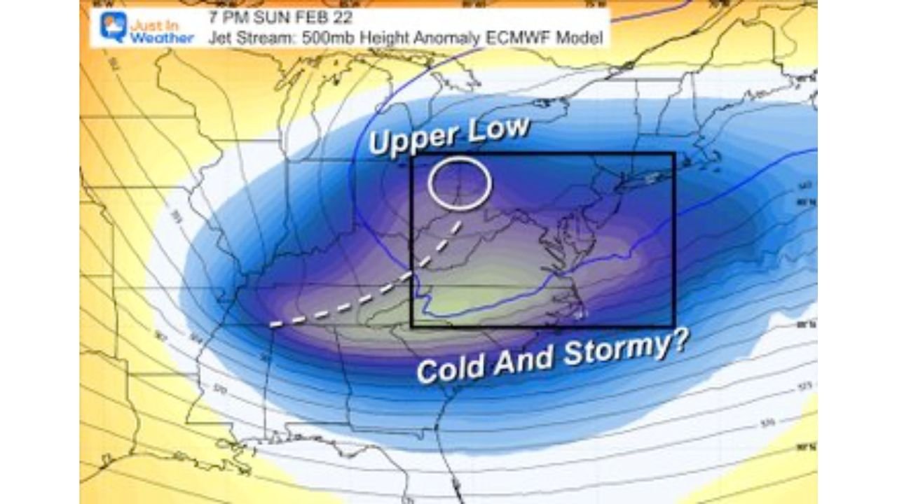
Upper Low and Cold Core Create ‘Cold and Stormy’ Setup
Forecast maps show a pronounced upper-level low pressure system dipping into the eastern half of the country Sunday evening. This feature is associated with colder air aloft and enhanced lift — two ingredients often linked to wintry precipitation.
The core of this upper low is positioned across the central Appalachians into the Mid-Atlantic region, with colder air filtering southward into Maryland, Pennsylvania, Virginia, and New Jersey. If moisture overlaps with this cold core at the right time, snowfall could develop.
However, the key phrase in this setup is timing. A mismatch between cold air and moisture could dramatically reduce snow potential.
Canadian vs. European Model Show Wide Contrast
One of the biggest challenges with this system is the stark contrast between major forecast models.
The Canadian model suggests stronger phasing of the jet stream overhead, allowing energy streams to align and amplify the system. In this scenario, storm organization improves and snow chances increase across the Mid-Atlantic into the Northeast.
Meanwhile, the European (ECMWF) model shows split energy that does not fully align in time. Without proper phasing, the storm remains weaker and less organized, limiting snowfall potential.
This disagreement explains why forecasters emphasize that confidence remains low. When global models diverge significantly at this range, outcomes can vary dramatically.
Jet Stream Phasing Will Decide Snow Outcome
The term “phasing jet stream overhead” refers to northern and southern branches of the jet stream merging at the right moment. When this occurs, storms can strengthen rapidly.
If phasing occurs over the Ohio Valley and Mid-Atlantic, snowfall probabilities increase for cities including Baltimore, Washington, D.C., Philadelphia, and possibly New York City.
If the jet energy remains split or misaligned, the system may pass offshore with minimal impact.
This delicate balance makes Sunday night’s potential highly conditional.
Ensemble and AI Guidance Show Measured Odds
Ensemble model data provides probability-based guidance rather than a single deterministic outcome. Current ensemble projections show measurable — but not overwhelming — chances for at least 1 inch of snow across parts of Maryland and southern Pennsylvania.
For Baltimore, probabilities hover near the 50 percent range for 1 inch or more, based on AI-assisted ensemble output. Areas farther north show somewhat higher probabilities, while southern regions trend lower.
Forecasters stress that snowfall maps displayed at this range are academic tools meant to illustrate possible outcomes. With more than three days before the event, all numbers are subject to change.
What to Watch Before Sunday Night
Key forecast factors include:
- Whether jet stream energy phases in time
- Strength and placement of the upper low
- Timing of moisture arrival
- Exact placement of the rain–snow line
Even minor shifts in track or timing could alter snow totals significantly.
At this stage, the developing storm represents a monitoring situation rather than a confirmed snow event. Confidence will improve as newer data narrows model differences.
Residents across Maryland, Pennsylvania, Virginia, and the broader Northeast should stay informed through the weekend as updates refine the outlook.
As winter weather patterns continue to evolve along the East Coast, ChicagoMusicGuide.com will provide ongoing coverage of storm setups, model trends, and potential snowfall impacts. For the latest forecast analysis and regional weather updates, visit ChicagoMusicGuide.com.