
Maryland, Pennsylvania, New Jersey, New York: Mid-February Winter Storm Signal Holds as Models Flip Warmer but Snow Risk Persists
BALTIMORE, MARYLAND — A potential mid-February storm system continues to demand attention across the Mid-Atlantic and Northeast, even as forecast models shift back and forth on how cold — and how snowy — the setup ultimately becomes. The latest data shows a notable split between warmer operational runs and steadier ensemble guidance, keeping snow on the table for parts of Maryland, Pennsylvania, New Jersey, and New York around February 15–16.
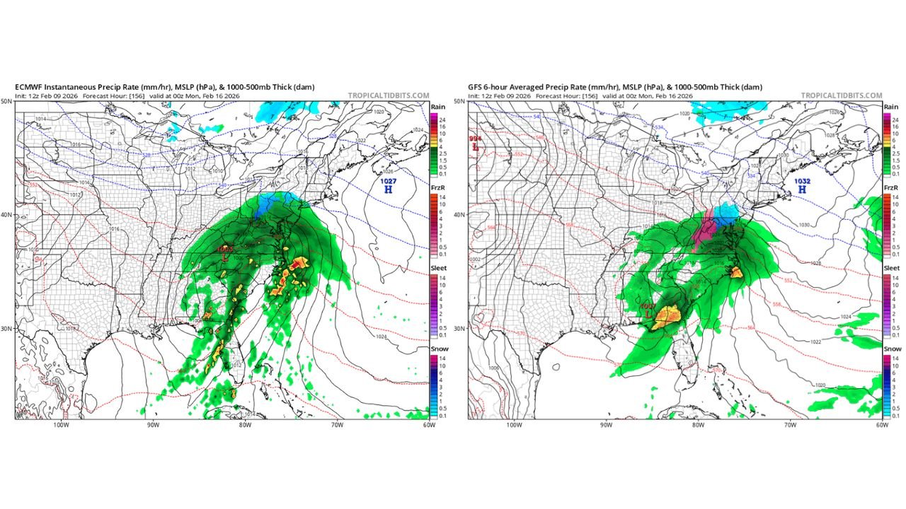
Why This Forecast Is So Tricky Right Now
Overnight model runs trended warmer as the storm appears more delayed, allowing cold air to retreat northward ahead of the system. That shift increases the risk of rain or a rain/sleet mix, especially closer to the coast. However, ensembles — which average dozens of model outcomes and are generally more reliable at this range — continue to show a consistent snow signal, particularly inland and north of the I-95 corridor.
This push-and-pull between timing and temperature is classic long-range winter forecasting, where small changes in storm speed can mean the difference between plowable snow and cold rain.
Snow Probabilities: What the Ensembles Are Saying
The latest ECMWF ensemble guidance shows a 30–40% chance of at least 3 inches of snow for the Baltimore metro area, with higher probabilities stretching northward into:
- Central and northern Pennsylvania
- Interior New Jersey
- Southern and eastern New York
These probabilities do not guarantee snow totals — but they are significant this far out and suggest the system cannot be dismissed as a non-event.
Operational Models vs Ensembles
- Operational runs (single model solutions): Trending warmer, implying more mixing or rain near the coast.
- Ensemble guidance: Holding firm on snow potential, especially inland and at higher elevations.
Historically, ensembles often outperform single runs when storms are 6–8 days out, particularly in complex winter setups like this one.
A Reminder From the Past
Forecasters are also pointing to past events — such as February 1, 2021, when parts of eastern Massachusetts saw an astonishing 17-inch snowfall gradient over just 7 miles. That storm was driven by coastal fronts and subtle thermal boundaries, highlighting just how extreme snowfall differences can be in marginal setups.
This upcoming system shows some of those same red flags: sharp temperature gradients, coastal influence, and timing-sensitive cold air.
What Happens Next
- If the storm speeds up, colder air is more likely to hold, boosting snow chances.
- If it slows down, warmer air could dominate early, leading to rain or mixed precipitation before any snow.
- The storm does not end at Day 7, meaning forecasters must lean into probabilities rather than exact totals.
Bottom Line
For now, the signal for a mid-February winter storm affecting Maryland, Pennsylvania, New Jersey, and New York remains alive, despite warmer short-term model trends. Snow is not locked in, but it is far from off the table, especially away from the immediate coast.
This is a classic case where patience — and ensemble guidance — matters most.
Stay with ChicagoMusicGuide.com for continued winter weather updates, model trends, and clear explanations as this forecast sharpens in the days ahead.