
Maryland, Pennsylvania, Virginia, and New Jersey Face Uncertain Mid-Week Snow Odds as ECMWF Data Shows Wide Forecast Spread
UNITED STATES — A potential mid-week winter weather setup is drawing cautious attention across Maryland, Pennsylvania, Virginia, New Jersey, and parts of the Northeast, but current forecast data strongly suggests that snow expectations remain highly uncertain and far from guaranteed. Ensemble guidance from the ECMWF model highlights why early snow maps can be misleading, showing a wide range of possible outcomes rather than a single reliable scenario.
While snow is possible in some locations between Wednesday and Friday, probabilities for meaningful accumulation remain modest, particularly in major metro areas.
What the ECMWF Snow Probability Data Actually Shows
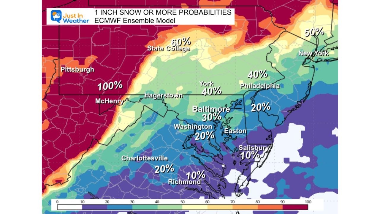
ECMWF ensemble probability maps focusing on 1 inch of snow or more show limited confidence across most populated areas. For example, Baltimore’s metro area sits in roughly the 30–40 percent range, a level that historically does not support strong confidence in impactful snowfall.
Farther north and west into western Pennsylvania and interior elevations, probabilities increase sharply, with some higher-terrain locations nearing near-certainty thresholds. However, these higher odds drop off quickly when moving toward the I-95 corridor, including Washington, Baltimore, Philadelphia, and southern New Jersey.
This sharp gradient is a key signal that small shifts in storm track or temperature profiles could dramatically change outcomes.
Why Early Snow Maps Can Be Misleading
The ECMWF ensemble consists of 50 different model simulations, each designed to test how small changes in the atmosphere could alter the final outcome. What many people see online, however, is often only a single deterministic run, which represents just one possible solution.
The ensemble images clearly show:
- Large variation in snow placement
- Inconsistent intensity from run to run
- Significant disagreement on how far south snow reaches
This spread confirms that forecast skill decreases farther out in time, especially beyond the three-day window.
What Confidence Is Higher On Right Now
While snowfall totals remain uncertain, several points are becoming clearer:
- Mountain and higher-elevation areas have a much better chance of seeing snow.
- Lower elevations and urban corridors face a higher risk of rain or minimal accumulation.
- Ground temperatures remain relatively warm, which may limit early accumulation even if snow falls.
- Timing remains unresolved, with overlaps between cold air and precipitation still uncertain.
As a result, this setup should be monitored, not hyped.
When a Clearer Snow Call Can Be Made
Meteorologists generally gain better clarity within three days of an event, when ensemble spread narrows and thermal profiles sharpen. That window is when first-call snowfall forecasts become more reliable and actionable.
Until then, any precise snowfall totals or dramatic snow maps should be viewed with caution.
Another system later in the week is also on the radar, but it remains too early to evaluate its potential impacts.
As winter patterns continue to evolve across the Mid-Atlantic and Northeast, staying grounded in probability — not hype — is key. For continued weather updates, clearer breakdowns, and responsible forecast context as confidence improves, keep following ChicagoMusicGuide.com for ongoing coverage and updates.