
Maryland, Virginia and Washington, D.C. See Drought Stabilize but Multi-Year Rainfall Deficits Linger in Baltimore and National Airport Data
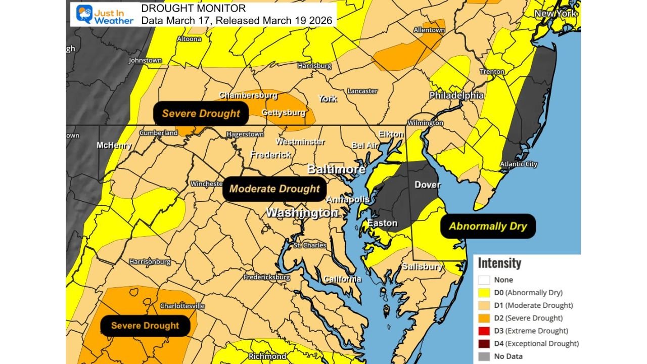
WASHINGTON, D.C. — The latest Drought Monitor update released March 19 shows conditions across Maryland, Northern Virginia and Washington, D.C. have improved compared to peak winter severity — but significant rainfall deficits remain, particularly around Baltimore.
Data completed March 17 highlights a region that is stabilizing, yet still carrying the weight of long-term dryness.
Moderate Drought Still Dominates the DC–Baltimore Corridor
The newest map shows:
- Moderate Drought (D1) covering much of central Maryland, Washington, D.C., and Northern Virginia
- Severe Drought (D2) lingering in portions of south-central Pennsylvania and parts of central Virginia
- Abnormally Dry (D0) conditions across portions of eastern Maryland and southern New Jersey
While the most extreme drought classifications have retreated compared to earlier winter conditions, widespread moderate drought remains entrenched across the I-95 corridor.
Baltimore (BWI): Multi-Year Deficit Still Deep
At Baltimore/Washington International Airport (BWI), rainfall totals show ongoing short-term and long-term dryness.
March to Date
- Observed: 1.87 inches
- Normal: 2.34 inches
- Departure: -0.47 inches
Year to Date
- Observed: 6.47 inches
- Normal: 8.32 inches
- Departure: -1.85 inches
More concerning is the longer-term trend. Combined rainfall deficits from 2024 and 2025 total -16.91 inches, underscoring how deeply rooted the regional drought has been.
Even with some recent improvement, Baltimore remains below normal entering late March.
Washington National (DCA): Near Normal but Trending Dry
At Ronald Reagan Washington National Airport (DCA), conditions are closer to average but still slightly dry.
March to Date
- Observed: 1.49 inches
- Normal: 2.00 inches
- Departure: -0.51 inches
Year to Date
- Observed: 7.22 inches
- Normal: 7.48 inches
- Departure: -0.26 inches
While overall precipitation for 2026 is near normal, a drier March has nudged the yearly total slightly below average.
Washington Dulles (IAD): A Relative Bright Spot
In contrast, Washington Dulles International Airport (IAD) shows modest surpluses.
March to Date
- Observed: 2.21 inches
- Normal: 1.99 inches
- Departure: +0.22 inches
Year to Date
- Observed: 8.01 inches
- Normal: 7.54 inches
- Departure: +0.47 inches
Dulles stands as the wettest of the three major airports in 2026 so far, reflecting localized variability across the region.
The Big Picture: Improved, But Not Recovered
Despite measurable rainfall in early March, the broader Mid-Atlantic still faces:
- Lingering moderate drought
- Multi-year rainfall deficits
- Uneven recovery between subregions
The data highlights how small geographic differences — even between major airports within 30 to 40 miles — can produce contrasting rainfall trends.
Baltimore remains the most concerning location from a deficit standpoint, while Dulles shows gradual stabilization.
What Happens Next
With March trending slightly below normal overall, additional rainfall will be necessary to meaningfully reduce drought classifications across:
- Maryland
- Northern Virginia
- Washington, D.C.
- Parts of central Virginia and southern Pennsylvania
The coming weeks will determine whether improvement continues — or if drying conditions return and stall progress.
Stay with ChicagoMusicGuide.com for ongoing coverage of drought conditions and regional climate trends across the Mid-Atlantic and beyond.