
Massachusetts, New York, New Jersey, Connecticut Brace for Potential Weekend Nor’easter as Models Hint at Heavy Snow, Wind, and Coastal Flooding
UNITED STATES — A developing storm system emerging from the northern Gulf of Mexico later this week is drawing close attention from forecasters as multiple weather models signal the potential for a significant nor’easter impacting Massachusetts, New York, New Jersey, and Connecticut this weekend, though uncertainty remains over the exact track and strength.
Meteorologists say this system would be very different from the recent inland winter storms, instead behaving like a classic coastal nor’easter — strengthening rapidly over the Atlantic before tracking northward along the Eastern Seaboard.
Storm Setup: Gulf Disturbance to Atlantic Coastal System
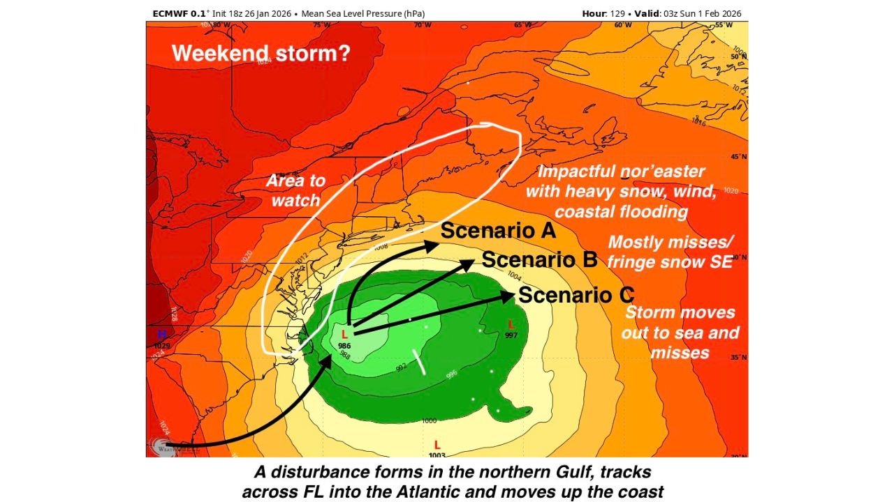
Current guidance shows a disturbance forming over the Gulf Coast, moving east across Florida, then emerging into the western Atlantic late Friday. Once offshore, the system may begin to intensify quickly as it encounters strong temperature contrasts and favorable upper-level support.
Forecasters note that rapid pressure drops of 24 millibars or more within 24 hours — known as bombogenesis — are on the table, which would significantly increase impacts if the storm tracks close enough to the coast.
Three Possible Tracks Now on the Table
Based on the latest ECMWF, GFS, and Canadian model guidance, meteorologists are outlining three primary scenarios:
Scenario A: High-Impact Coastal Track (40% chance)
The storm strengthens rapidly and moves north near the 40°N / 70°W benchmark, delivering heavy snow, strong winds, and coastal flooding to eastern New Jersey, Long Island, coastal Connecticut, Rhode Island, and Massachusetts. This would be the most disruptive outcome, with blizzard-like conditions possible in parts of New England.
Scenario B: Offshore but Close Enough (40% chance)
The system tracks farther northeast but still close enough to bring fringe snowfall, gusty winds, and above-normal tides to southeastern New England. Impacts would be more limited but still noticeable, especially along the coast.
Scenario C: Miss to the South and East (20% chance)
The storm turns out to sea early, missing the Northeast almost entirely with minimal impacts.
At this stage, Scenario C is considered the least likely, though forecasters stress that confidence remains limited this far out.
Snow, Wind, and Coastal Flooding Concerns
If the storm follows the stronger coastal track, cold air already in place across the Northeast would support heavy snow, potentially producing plowable accumulations inland and difficult travel conditions.
Strong northeasterly winds could lead to blowing snow and reduced visibility, while the combination of a strengthening storm, full moon, and high astronomical tides raises concern for coastal flooding and beach erosion, particularly along exposed shorelines.
Another issue officials are monitoring closely: snow storage capacity. Many cities across the Northeast are already running low on places to put additional snowfall, which could complicate cleanup efforts if heavy snow materializes.
Timing: Saturday Night into Sunday
Current projections place the highest impact window from Saturday night through Sunday, though exact timing will depend on how quickly the storm organizes and where it tracks offshore.
Forecasters emphasize that model trends over the next 24–48 hours will be critical in determining whether this system becomes a major winter storm or a near-miss.
What to Watch Going Forward
Residents across the Northeast and Mid-Atlantic are urged to stay weather-aware as forecast confidence improves later this week. Even small shifts in storm track could mean the difference between significant snowfall and minimal impact, especially near the coast.
Updates are expected daily as new data comes in and models converge on a clearer solution.
Stay tuned to ChicagoMusicGuide.com for continued coverage, model updates, and impact breakdowns as this potential nor’easter evolves.