
Massachusetts Snow Forecast Narrows to Cape Cod and Islands as Sunday System Skirts South Shore
BOSTON, MASSACHUSETTS — The latest forecast update for Sunday’s snow potential in Massachusetts shows a much more limited impact area, with accumulating snow now expected primarily across Cape Cod, the Islands, and parts of the South Shore, while the rest of the state sees little to no accumulation. Forecasters say a subtle shift in the storm track keeps most inland locations out of the snow zone.
Snow Timing Focused on Early Sunday Morning
According to the National Weather Service Boston/Norton, snow is expected to arrive very early Sunday morning, shortly after midnight Saturday night. The steadiest snowfall is forecast to occur during the daytime hours on Sunday, especially across Cape Cod and the Islands.
Snow should begin to taper off Sunday evening, with lingering snow showers ending late Sunday night for Cape Cod and Nantucket. Forecasters rate timing confidence as high, meaning the general arrival and departure window is unlikely to change.
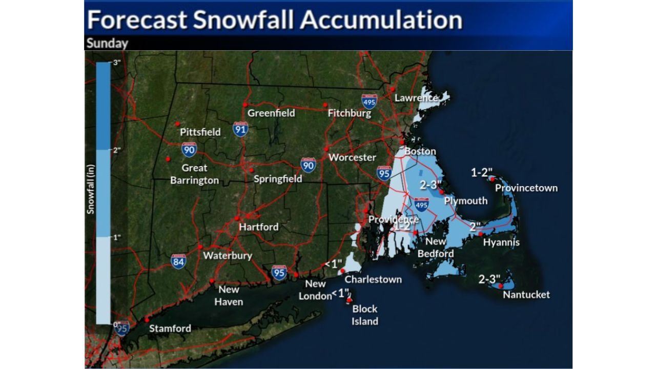
Accumulation Limited to Coastal Massachusetts
Updated snowfall projections indicate most inland Massachusetts will see little to no snow, including Boston, Worcester, Springfield, and much of central and western Massachusetts.
Expected snowfall totals include:
- Cape Cod: 2 to 3 inches
- Nantucket: 2 to 3 inches
- Plymouth and outer South Shore: 1 to 2 inches
- Boston and inland areas: little to no accumulation
Forecasters emphasize that snow amount confidence remains medium, as even a small shift north or south in the system’s track could slightly alter totals along the immediate coast.
Travel Impacts Mainly Along the Southeast Coast
While this will not be a major statewide snow event, travel impacts are still possible in southeastern coastal Massachusetts, particularly where gusty winds combine with periods of steady snow.
Drivers in Cape Cod, the Islands, and the South Shore may encounter reduced visibility at times, especially during heavier bursts of snow. Road conditions could become slick, particularly on untreated surfaces and bridges.
Elsewhere across the state, travel impacts are expected to be minimal.
Why Most of Massachusetts Misses This Snow
Meteorologists explain that the storm system remains just far enough offshore to prevent widespread snow from reaching inland Massachusetts. The best lift and moisture stay focused near the outer coastline, limiting snowfall to areas closest to the Atlantic.
This type of setup is common in marginal coastal systems, where Cape Cod and the Islands often receive snow while the rest of the state remains largely unaffected.
What to Expect Going Forward
While Sunday’s snow will be highly localized, residents in coastal communities should still plan for brief winter travel conditions and monitor updates in case of any last-minute track adjustments.
As February begins, forecasters note that winter weather opportunities remain ahead, even if this particular system delivers only a narrow coastal impact.
For continued updates on New England weather forecasts, winter outlooks, and travel conditions, visit ChicagoMusicGuide.com.