
Massive Arctic Blast to Slam the Midwest and Eastern U.S. as Temperatures Plunge Into Dangerous Territory
ILLINOIS — A Major Arctic Blast Is Set to Sweep Into the Midwest and Eastern U.S. Beginning Sunday, A powerful surge of Arctic air is barreling southward from Alaska and northwest Canada, and new forecast graphics warn that it may become the strongest cold wave of December for millions across the United States.
Temperatures in parts of interior Alaska are currently between –40°F and –50°F, and that brutally cold air mass is expected to spill south this weekend — reaching the Midwest on Sunday and sweeping into the Eastern United States by Monday.
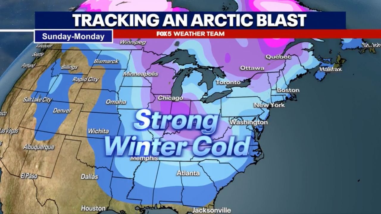
Early forecasting maps show a wide stretch of frigid temperatures settling over major hubs including Chicago, Minneapolis, Detroit, Indianapolis, Pittsburgh, New York, and Washington, D.C. The FOX5 Weather Team graphics highlight a deep plunge of cold stretching from the Upper Midwest through the Ohio Valley and into the Mid-Atlantic.
A Direct Shot of Arctic Air: What the Forecast Maps Show
The weather model data and broadcast forecasts all tell a consistent story:
This will be a sharp, fast-moving intrusion of dangerous winter air.
Key points shown in the images:
- A large dome of blue and purple temperature anomalies covers the central and eastern U.S.
- Chicago and the Great Lakes sit directly in the core of the coldest air.
- Rapid southward movement from Alaska/Northwest Canada brings sub-freezing temperatures into the Plains by late Saturday.
- By Sunday into Monday, the cold expands across the East Coast.
- Wind chills in parts of the Midwest may reach dangerously low levels, especially overnight.
The phrase shown on the map — “Strong Winter Cold” — is not an exaggeration. This pattern resembles classic early-season Arctic outbreaks that can trigger single-digit lows, icy roads, and sharply increased heating demand.
Why This Blast Is Notable
Forecast discussions emphasize that this wave stands out for several reasons:
1. It may be the strongest cold wave of December so far.
Forecasters called it “shockingly strong” given how consistently cold the month has already been for many regions.
2. It’s powered by extreme cold already present in the far north.
Air currently recorded at –40°F to –50°F in Alaska and Northwest Canada is “primed” to surge southward.
3. Millions will feel the effects, from the Plains to the East Coast.
This is not a localized event — it’s a broad, continental-scale cold outbreak.
Expected Impacts Across the Midwest and Eastern U.S.
Residents across multiple states should prepare for:
- Rapid temperature drops beginning late Saturday
- Wind chills below zero in portions of the Midwest
- Hazardous travel as refreezing and icy conditions develop
- Possible school delays or closures Monday morning in affected areas
- Increased heating demands and higher short-term energy usage
- Potential for lake-effect snow downwind of the Great Lakes
Cities at highest risk for severe cold include:
Chicago, Milwaukee, Minneapolis, Detroit, Cleveland, Indianapolis, Columbus, Pittsburgh, Philadelphia, Washington D.C., and New York City.
How Long Will the Cold Last?
Based on the pattern shown, forecasters expect:
- The coldest period: Sunday night through Tuesday morning
- Gradual moderation mid-week
- Another possible reinforcing shot of cold behind the initial wave — still under review
At this stage, the cold wave does not appear to be accompanied by a major snowstorm, but light to moderate snow showers are possible in many areas.
Prepare Now: Safety Tips Before the Arctic Air Arrives
- Check furnaces and space heaters to ensure proper operation
- Insulate pipes to prevent freezing
- Stock winter car kits, including blankets and emergency supplies
- Limit outdoor exposure during the coldest hours
- Bring pets indoors
Extreme cold remains one of the most dangerous weather hazards in the U.S., causing more fatalities each year than heat, storms, or flooding.
Stay Informed
This Arctic blast is developing quickly, and forecast refinements are expected over the next 48 hours. Readers should follow updates from the National Weather Service, local meteorologists, and verified weather outlets as the system approaches.
What do you think — is this the coldest wave we’ll see this month, or could January bring something even stronger? Share your thoughts and stay connected with ChicagoMusicGuide.com for ongoing weather updates.