
Michigan and Indiana Face Repeated Lake-Effect Snow Bands as Lake Michigan Fuels Days of Accumulating Snow
GRAND RAPIDS, MICHIGAN — A prolonged stretch of lake-effect snow is shaping up across Michigan and Indiana over the next seven days, as cold air repeatedly crosses Lake Michigan, allowing intense snow bands to redevelop tomorrow, Thursday, and again over the weekend. Forecast models consistently show accumulating snow returning in waves, with some locations seeing multiple rounds while others just miles away experience lighter impacts.
Why Lake Michigan Is Driving This Snow Pattern
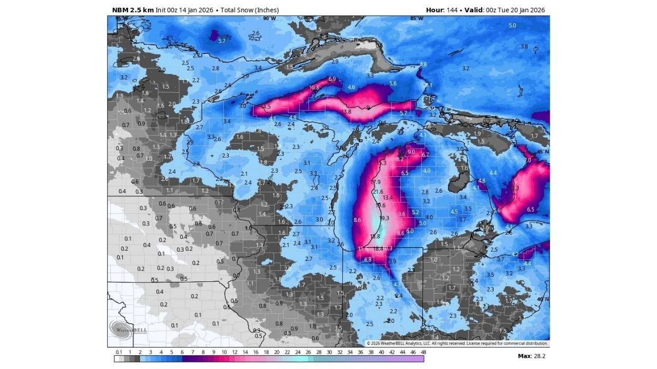
The latest NBM snowfall guidance highlights a textbook Lake Michigan lake-effect setup, where cold northwest flow interacts with comparatively warmer lake waters. This contrast fuels narrow but powerful snow bands that can rapidly intensify once they organize. Western Michigan, especially areas downwind of the lake, and parts of northwest Indiana are positioned to see the greatest impacts when bands lock into place.
Unlike widespread synoptic snowstorms, lake-effect snow produces sharp cutoffs. One community may see several inches in a few hours, while nearby towns receive far less. The snow maps reflect this risk clearly, showing elongated, high-accumulation streaks hugging the eastern shoreline of Lake Michigan and extending inland depending on wind direction.
Timing: Multiple Rounds Through The Week And Weekend
Forecast data suggests this will not be a one-day event. The most active period begins tomorrow into Thursday, when the first organized bands set up and begin producing steady accumulation. A brief lull is possible before conditions reload again over the weekend, bringing another chance for heavier bursts of snow.
This stop-and-start nature increases real-world impacts. Roads may improve temporarily, only to deteriorate again when bands shift back overhead. Gusty winds accompanying the snow can also lead to blowing snow and sudden drops in visibility, especially during overnight and early-morning hours.
Where Accumulations Could Add Up Fast
The snow maps indicate the highest totals are most likely in western Michigan, including areas from the lakeshore inland, where persistent bands could remain anchored for hours. Portions of northwest Indiana may also see meaningful accumulation if bands drift southward or temporarily stall.
Even outside the core lake-effect corridor, lighter snow showers are expected across much of Michigan and Indiana, adding up gradually over several days. This widespread light accumulation can still create slick roads, especially on untreated surfaces and secondary highways.
How This Pattern Could Expand Beyond Lake Effect
While the near-term forecast focuses on lake-effect snow, longer-range model guidance hints that the broader atmospheric pattern could remain active. Some simulations suggest the potential for a more organized system later in January, which could enhance snowfall across the Great Lakes and possibly beyond.
That said, confidence decreases with time. Small shifts in upper-level energy or wind direction can dramatically change snowfall placement, particularly in lake-effect scenarios. For now, the strongest signal is clear: Michigan and Indiana are entering a snowy stretch where accumulations will build incrementally rather than all at once.
Travel And Event Impacts To Watch Closely
For residents, commuters, and music fans traveling to shows across Michigan and Indiana, timing will be critical. Evening travel may begin under manageable conditions and quickly worsen if a snow band redevelops. Highways running east-west across the lake-effect zone are especially vulnerable to sudden whiteouts.
Touring crews and concertgoers heading toward cities like Grand Rapids, Kalamazoo, Detroit, South Bend, and Fort Wayne should plan extra buffer time and monitor local forecasts close to departure. Lake-effect snow is notoriously difficult to pin down more than a few hours in advance, making flexibility essential.
As winter weather continues to influence travel and live events across the Midwest, stay connected with ChicagoMusicGuide.com for timely updates that break down how evolving snow patterns could affect upcoming shows, road conditions, and regional travel plans.